Orleans (/ɔːrˈliːnz/ or-LEENZ) is a town in Barnstable County, Massachusetts situated along Cape Cod. The population was 6,307 at the 2020 census.[1]
Orleans, Massachusetts | |
|---|---|
 Orleans Town Hall | |
 Flag  Seal | |
 Location in Barnstable County and the state of Massachusetts. | |
| Coordinates: 41°47′23″N 69°59′25″W / 41.78972°N 69.99028°W | |
| Country | United States |
| State | Massachusetts |
| County | Barnstable |
| Settled | 1693 |
| Incorporated | 1797 |
| Government | |
| • Type | Open town meeting |
| Area | |
| • Total | 22.7 sq mi (58.7 km2) |
| • Land | 14.1 sq mi (36.6 km2) |
| • Water | 8.5 sq mi (22.0 km2) |
| Elevation | 60 ft (18 m) |
| Population (2020) | |
| • Total | 6,307 |
| • Density | 446/sq mi (172.3/km2) |
| Time zone | UTC−5 (Eastern) |
| • Summer (DST) | UTC−4 (Eastern) |
| ZIP Code | 02653 |
| Area code | 508 |
| FIPS code | 25-51440 |
| GNIS feature ID | 0618257 |
| Website | www |
For geographic and demographic information on the census-designated place Orleans, please see the article Orleans (CDP), Massachusetts.
History edit
Orleans was settled in 1693 by Pilgrims from the Plymouth Colony who were dissatisfied with the poor soil and small tracts of land granted to them. The town was officially separated from Eastham and incorporated in 1797. It was named in honor of Louis Philippe II, Duke of Orléans in recognition of France's support for the Thirteen Colonies during the American Revolution and because the town did not want an English name, as they had been captured twice by the British during the war.
The town's early history revolved around fishing, whaling, and agriculture. As the fishing industry grew, salt works sprang up to help preserve the catches. However, the town's growth depleted it of lumber, a situation that did not begin to be remedied until the railroad came and brought lumber from the mainland in the 19th century. The railroad also brought tourism to the town. In 1898, the French Cable Company built a 3,200-mile-long (5,100 km) transatlantic telegraph cable to Orleans, which operated from the French Cable Station.[2]
Orleans was shelled by a German submarine in July 1918, during World War I. The town's tourism industry was helped in 1961 with the creation of the Cape Cod National Seashore by President John F. Kennedy.[3]
-
 The Orleans Inn, between Town Cove and Route 28
 -
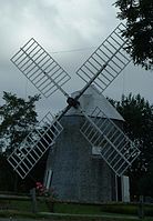 The Jonathan Young Windmill, a restored, working eighteenth-century windmill next to Town Cove


Geography edit
According to the United States Census Bureau, the town has a total area of 22.7 square miles (58.7 km2), of which 14.1 square miles (36.6 km2) is land and 8.5 square miles (22.0 km2), or 37.59%, is water.[4] Orleans is bordered by Eastham to the north, the Atlantic Ocean to the east, Pleasant Bay and the town of Chatham to the south, Harwich to the southwest, Brewster to the west, and Cape Cod Bay to the northwest.
Orleans is 27 miles (43 km) south of Provincetown, 22 miles (35 km) east of Barnstable, 36 miles (58 km) east of the Sagamore Bridge, and 90 miles (140 km) southeast of Boston. Orleans is located on the inner "elbow" section of Cape Cod. Bogs and ponds dot the western part of town, while there are many inlets, islands and harbors along the eastern coast of the town, including Town Cove, Nauset Harbor, Pleasant Bay, and Little Pleasant Bay. Rock Harbor, bounded by and shared with the town of Eastham, is located in the "crease" of the inner elbow and provides boating access to Cape Cod Bay. Cape Cod National Seashore lies along the coast as well.
Transportation edit
The town line between Eastham and Orleans is the site of the termini of Massachusetts Routes 6A and 28. The two routes join in the Orleans town center and end at a rotary with Route 6 at the Eastham town line. Massachusetts Route 39, which traces a portion of the Brewster town line, ends in the southern part of Orleans at Route 28. Other than two small non-outleted lanes, only Route 6 and Bridge Road pass northward into Eastham. Orleans has no rail or air service in town. The nearest regional air service can be reached in nearby Chatham, and the nearest national and international airport is Logan International Airport in Boston.
Climate edit
The town of Orleans has a mild summer Humid continental climate (Dfb). The plant hardiness zone is 7a with an average annual extreme minimum air temperature of 4.0 °F (−15.6 °C).[5] The average seasonal (Nov.–Apr.) snowfall total is around 30 in (76 cm). The average snowiest month is February which corresponds to the annual peak in nor'easter activity.
| Climate data for Orleans, Barnstable County, Massachusetts (1981–2010 averages). | |||||||||||||
|---|---|---|---|---|---|---|---|---|---|---|---|---|---|
| Month | Jan | Feb | Mar | Apr | May | Jun | Jul | Aug | Sep | Oct | Nov | Dec | Year |
| Mean daily maximum °F (°C) | 37.9 (3.3) |
39.1 (3.9) |
44.1 (6.7) |
52.1 (11.2) |
61.3 (16.3) |
70.0 (21.1) |
76.6 (24.8) |
76.3 (24.6) |
70.1 (21.2) |
60.3 (15.7) |
52.3 (11.3) |
43.7 (6.5) |
57.1 (13.9) |
| Daily mean °F (°C) | 31.3 (−0.4) |
32.5 (0.3) |
37.5 (3.1) |
45.6 (7.6) |
54.4 (12.4) |
63.5 (17.5) |
70.0 (21.1) |
69.8 (21.0) |
63.7 (17.6) |
53.9 (12.2) |
46.0 (7.8) |
37.0 (2.8) |
50.5 (10.3) |
| Mean daily minimum °F (°C) | 24.8 (−4.0) |
25.9 (−3.4) |
30.8 (−0.7) |
39.0 (3.9) |
47.6 (8.7) |
57.0 (13.9) |
63.5 (17.5) |
63.3 (17.4) |
57.2 (14.0) |
47.5 (8.6) |
39.7 (4.3) |
30.4 (−0.9) |
44.0 (6.7) |
| Average precipitation inches (mm) | 3.78 (96) |
3.52 (89) |
4.46 (113) |
4.36 (111) |
3.48 (88) |
3.58 (91) |
2.95 (75) |
3.64 (92) |
3.65 (93) |
3.89 (99) |
4.10 (104) |
3.95 (100) |
45.36 (1,152) |
| Average relative humidity (%) | 72.2 | 70.9 | 68.6 | 70.9 | 73.5 | 77.4 | 79.9 | 79.6 | 78.5 | 76.0 | 72.3 | 71.1 | 74.3 |
| Source: PRISM Climate Group[6] | |||||||||||||
| Month | Jan | Feb | Mar | Apr | May | Jun | Jul | Aug | Sep | Oct | Nov | Dec | Year |
|---|---|---|---|---|---|---|---|---|---|---|---|---|---|
| Average Dew Point °F | 23.4 | 24.1 | 28.1 | 36.7 | 46.1 | 56.3 | 63.5 | 63.2 | 56.9 | 46.5 | 37.6 | 28.5 | 42.7 |
| Average Dew Point °C | −4.8 | −4.4 | −2.2 | 2.6 | 7.8 | 13.5 | 17.5 | 17.3 | 13.8 | 8.1 | 3.1 | −1.9 | 5.9 |
Source: PRISM Climate Group[7]
| |||||||||||||
Demographics edit
| Year | Pop. | ±% |
|---|---|---|
| 1850 | 1,848 | — |
| 1860 | 1,678 | −9.2% |
| 1870 | 1,323 | −21.2% |
| 1880 | 1,294 | −2.2% |
| 1890 | 1,219 | −5.8% |
| 1900 | 1,123 | −7.9% |
| 1910 | 1,077 | −4.1% |
| 1920 | 1,012 | −6.0% |
| 1930 | 1,181 | +16.7% |
| 1940 | 1,451 | +22.9% |
| 1950 | 1,759 | +21.2% |
| 1960 | 2,342 | +33.1% |
| 1970 | 3,055 | +30.4% |
| 1980 | 5,306 | +73.7% |
| 1990 | 5,838 | +10.0% |
| 2000 | 6,341 | +8.6% |
| 2010 | 5,890 | −7.1% |
| 2020 | 6,307 | +7.1% |
| 2022 | 6,422 | +1.8% |
| *=population estimates only Source: United States census records and Population Estimates Program data.[8][9][10][11][12][13][14][15][16][17][18] | ||
As of the census[19] of 2000, there were 6,341 people, 3,087 households, and 1,771 families residing in the town. The population density was 447.3 inhabitants per square mile (172.7/km2). There were 5,073 housing units at an average density of 357.9 per square mile (138.2/km2). The racial makeup of the town was 97.57% White, 0.58% Black or African American, 0.17% Native American, 0.54% Asian, 0.14% from other races, and 0.99% from two or more races. Hispanic or Latino of any race were 0.77% of the population.
There were 3,087 households, out of which 14.8% had children under the age of 18 living with them, 49.4% were married couples living together, 6.0% had a female householder with no husband present, and 42.6% were non-families. Of all households, 37.2% were made up of individuals, and 21.9% had someone living alone who was 65 years of age or older. The average household size was 2.00 and the average family size was 2.55.
In the town, the population was spread out, with 13.8% under the age of 18, 3.5% from 18 to 24, 17.3% from 25 to 44, 29.4% from 45 to 64, and 36.0% who were 65 years of age or older. The median age was 56 years. For every 100 females, there were 87.4 males. For every 100 females age 18 and over, there were 84.2 males.
The median income for a household in the town was $42,594, and the median income for a family was $62,909. Males had a median income of $44,246 versus $30,017 for females. The per capita income for the town was $29,553. About 2.7% of families and 6.5% of the population were below the poverty line, including 5.6% of those under age 18 and 5.6% of those age 65 or over.
Government edit
Orleans is represented in the Massachusetts House of Representatives as a part of the Fourth Barnstable district, which includes (with the exception of Brewster) all the towns east and north of Harwich on the Cape. The town is represented in the Massachusetts Senate as a part of the Cape and Islands District, which includes all of Cape Cod, Martha's Vineyard and Nantucket except the towns of Bourne, Falmouth, Sandwich and Mashpee.[20] The town is patrolled by the Second (Yarmouth) Barracks of Troop D of the Massachusetts State Police.[21]
On the national level, Orleans is a part of Massachusetts's 9th congressional district, and is currently represented by William R. Keating. The state's senior (Class I) member of the United States Senate, elected in 2012, is Elizabeth Warren. The junior (Class II) member, elected in 2013, is Ed Markey.
Orleans is governed by the open town meeting form of government, and is led by a town manager and a board of selectmen. The town has its own police and fire departments, both headquartered south of the Route 6A – Route 28 intersection. There are three post offices, in East Orleans, Orleans Center and South Orleans. The Snow Library, named for the original benefactor of the library, is located in Orleans Center, and is supported by the Cape Libraries Automated Materials Sharing (CLAMS) library network. The town also operates several beaches, boat landings, and small parks, and has a historical society and museum called the Centers for Culture and History in Orleans[22] which meets in the town's original meeting house (across the street from the current Town Hall). Orleans is the site of a county courthouse, which serves much of the lower Cape.
Education edit
Orleans, along with Brewster, Eastham and Wellfleet, belongs to the Nauset Regional School District. Each town provides schooling for their own elementary students, and collectively send their middle and high school students to regional schools. Orleans operates the Orleans Elementary School for students from kindergarten through fifth grade. The town is home to Nauset Regional Middle School, which serves students from sixth through eighth grade for the district. High school students attend Nauset Regional High School in North Eastham, but also have the option of attending Cape Cod Regional Technical High School in Harwich free of charge.
Sports and recreation edit
.jpg)
Orleans is home to the Orleans Firebirds, an amateur collegiate summer baseball team in the Cape Cod Baseball League. The team plays at Eldredge Park, and has featured dozens of players who went on to careers in Major League Baseball such as Frank Thomas, Nomar Garciaparra, and Marcus Stroman.
Attacks in wartime edit
Orleans is on an exposed portion of the coast and has been a target in wartime. In 1814, its residents repelled an invasion of British marines from HMS Newcastle during the War of 1812. Nauset Beach was the only United States site hit by foreign munitions during World War I; the shells were apparently aimed at barges close off shore. This was the first time that a foreign nation had fired artillery on United States soil since the Siege of Fort Texas in 1848.
Orleans Arena Theater edit
The Orleans Arena Theater was founded by Betsy (born 1922) and Gordon Argo (born 1924) in 1950 for performing summer stock theater in the round. The couple's three children, Allison, Elizabeth and Walter, grew up around the theater and helped their parents run it. The children also acted in some of the theater's productions. Kurt Vonnegut, Jr. wrote a play, Penelope, that was performed at the theater. Penelope later became Happy Birthday, Wanda June, a feature film released in 1971. By 1976 the Argos had long since divorced and for various reasons the theater was sold by Mrs. Argo. It is now known as the Academy of Performing Arts.[23]
See also edit
References edit
- ^ "Census - Geography Profile: Orleans town, Barnstable County, Massachusetts". U.S. Census Bureau. Retrieved October 6, 2021.
- ^ Museum History (French Cable Station Museum)
- ^ Cape Cod, Martha's Vineyard and Nantucket Street Atlas. South Easton, MA: Arrow Maps Inc., 2004, p. 70.
- ^ "Geographic Identifiers: 2010 Demographic Profile Data (G001): Orleans town, Barnstable County, Massachusetts". U.S. Census Bureau, American Factfinder. Archived from the original on February 12, 2020. Retrieved December 6, 2013.
- ^ "USDA Interactive Plant Hardiness Map". United States Department of Agriculture. Archived from the original on July 4, 2019. Retrieved June 28, 2019.
- ^ "PRISM Climate Group, Oregon State U". www.prism.oregonstate.edu. Retrieved June 26, 2019.
- ^ "PRISM Climate Group, Oregon State U". www.prism.oregonstate.edu. Retrieved June 27, 2019.
- ^ "Total Population (P1), 2010 Census Summary File 1". American FactFinder, All County Subdivisions within Massachusetts. United States Census Bureau. 2010.
- ^ "Massachusetts by Place and County Subdivision - GCT-T1. Population Estimates". United States Census Bureau. Retrieved July 12, 2011.
- ^ "1990 Census of Population, General Population Characteristics: Massachusetts" (PDF). US Census Bureau. December 1990. Table 76: General Characteristics of Persons, Households, and Families: 1990. 1990 CP-1-23. Retrieved July 12, 2011.
- ^ "1980 Census of the Population, Number of Inhabitants: Massachusetts" (PDF). US Census Bureau. December 1981. Table 4. Populations of County Subdivisions: 1960 to 1980. PC80-1-A23. Retrieved July 12, 2011.
- ^ "1950 Census of Population" (PDF). Bureau of the Census. 1952. Section 6, Pages 21-10 and 21-11, Massachusetts Table 6. Population of Counties by Minor Civil Divisions: 1930 to 1950. Retrieved July 12, 2011.
- ^ "1920 Census of Population" (PDF). Bureau of the Census. Number of Inhabitants, by Counties and Minor Civil Divisions. Pages 21-5 through 21-7. Massachusetts Table 2. Population of Counties by Minor Civil Divisions: 1920, 1910, and 1920. Retrieved July 12, 2011.
- ^ "1890 Census of the Population" (PDF). Department of the Interior, Census Office. Pages 179 through 182. Massachusetts Table 5. Population of States and Territories by Minor Civil Divisions: 1880 and 1890. Retrieved July 12, 2011.
- ^ "1870 Census of the Population" (PDF). Department of the Interior, Census Office. 1872. Pages 217 through 220. Table IX. Population of Minor Civil Divisions, &c. Massachusetts. Retrieved July 12, 2011.
- ^ "1860 Census" (PDF). Department of the Interior, Census Office. 1864. Pages 220 through 226. State of Massachusetts Table No. 3. Populations of Cities, Towns, &c. Retrieved July 12, 2011.
- ^ "1850 Census" (PDF). Department of the Interior, Census Office. 1854. Pages 338 through 393. Populations of Cities, Towns, &c. Retrieved July 12, 2011.
- ^ "City and Town Population Totals: 2020-2022". United States Census Bureau. Retrieved October 21, 2023.
- ^ "U.S. Census website". United States Census Bureau. Retrieved January 31, 2008.
- ^ Index of Legislative Representation by City and Town, from Mass.gov Archived September 29, 2007, at the Wayback Machine
- ^ Station D-2, SP Yarmouth Archived March 16, 2007, at the Wayback Machine
- ^ "Orleans Historical Society | Newsletters".
- ^ Orleans Arena Theater documentary profile