The Titiwangsa Mountains (Malay: Banjaran Titiwangsa; Jawi: بنجرن تيتيوڠسا, pronounced [ˈband͡ʒaˈran titiwaŋˈsa]), also known as Banjaran Besar (lit. 'main range') by locals, is the chain of mountains that forms the backbone of the Malay Peninsula. The northern section of the range is in southern Thailand, where it is known as Sankalakhiri Range (Thai: ทิวเขาสันกาลาคีรี; RTGS: Thio Khao Sankalakhiri; pronounced [tʰīw kʰǎw sǎn.kāːlāːkʰīːrīː]).
| Titiwangsa Mountains | |
|---|---|
| Banjaran Titiwangsa/Besar (Malay) ทิวเขาสันกาลาคีรี (Thai) | |
_near_Gunung_Suku.jpg) The view of the Titiwangsa Mountains near Mount Suku. | |
| Highest point | |
| Peak | Gunung Korbu |
| Elevation | 2,183 m (7,162 ft) |
| Dimensions | |
| Length | 480 km (300 mi) NW/SE |
| Width | 120 km (75 mi) NE/SW |
| Geography | |
| Countries | Thailand and Malaysia |
| Provinces/States | Songkhla, Yala, Narathiwat, Perak, Kelantan, Pahang, Selangor and Negeri Sembilan |
| Range coordinates | 5°58′12″N 101°19′37″E / 5.9699°N 101.3269°E |
| Parent range | Tenasserim Hills |
| Geology | |
| Age of rock | Permian and Triassic |
| Type of rock | Granite and limestone |

The mountain range acts as a natural divider, dividing Peninsular Malaysia, as well as southernmost Thailand, into east and west coast regions. It also serves as a drainage divide of some major rivers of Peninsular Malaysia such as the Pahang, Perak, Kelantan, Klang and Muar. The length of mountain range is about 480 km from north to south.
Geology edit

.jpg)
The Titiwangsa Mountains is part of a suture zone that runs north–south, starting in Thailand at the Nan-Uttaradit suture zone (partly coincident with the Dien Bien Phu fault), and extending south towards Peninsular Malaysia (Bentong-Raub suture zone).[1] The eastern half of the Titiwangsa Mountains in Peninsular Malaysia is an amalgamation of continental terranes known as Cimmeria or Indochina, whereas the western half is an amalgamation of continental terranes Sinoburmalaya or Sibumasu. These two halves of terranes were separated by the Paleo-Tethys Ocean.[2][3]
The Cimmeria was separated from Gondwana around 400 mya during the Devonian and rifted towards Laurasia, the northeastern arm of Pangea. It attached to Laurasia completely around 280 mya during the Late Permian.
Sibumasu terranes on the other hand, only started to separate from Gondwana during the Early Permian and rifted towards Indochina. The collision of Sibumasu terranes and Indochina terranes during 200mya Late Triassic resulted in the closure of the Paleo-Tethys Ocean and formation of the modern Titiwangsa Mountain belts.
Seismic hazards edit
Peninsular Malaysia, while being tectonically stable, has a history of intraplate earthquakes,[4] with most of them are of low magnitude. As the Bentong-Raub suture runs parallel to the Titiwangsa Mountains, a large network of fault lines also crisscross the mountain range.[5] The known major fault lines in the mountains are the Bukit Tinggi, Kuala Lumpur and Seremban fault lines, with the first two being the most active.
Between 1984 and 2013, there had been tremors ranging from 1.6 to 4.6 on the Richter scale with local epicentres in Kenyir Lake, Manjung, Temenggor, Bukit Tinggi and Kuala Pilah, the latter three being situated along the Titiwangsa Mountains. As a precautionary move, the Department of Minerals and Geosciences pitched 23 Earthquake Benchmark (PAG, Malay: Penanda Aras Gempa) stations around earthquake-prone areas in Peninsular Malaysia, with 13 in Pahang, six in Selangor, and two each in Perak and Negeri Sembilan to monitor possible movements within the fault network.[6] The Ministry of Natural Resources, Environment and Climate Change (NRECC) also pointed out that strong earthquakes centred in neighbouring Sumatra, Indonesia could potentially activate ancient faults in Peninsular Malaysia and the effects of tremors could be felt around areas along the west coast of Peninsular Malaysia.
Geography edit

This mountain range is a part of the wider Tenasserim Hills system. It forms the southernmost section of the Indo-Malayan cordillera which runs from Tibet through the Kra Isthmus into the Malay Peninsula.[7]
The Titiwangsa Mountains proper begins in the north as the Sankalakhiri Range, a prolongation of the Nakhon Si Thammarat Range which includes the smaller Pattani, Taluban, and Songkhla sub-ranges. The Sankalakhiri marks the border between the Southern Thailand provinces of Yala in west and Narathiwat in the east. Across the border into Malaysia, the main stretch of the range runs in a northwest–southeast orientation, straddling the borders between the west coast states of Perak and Selangor with Kelantan and Pahang on the eastern side of the peninsula. From the tripoint of Pahang, Selangor and Negeri Sembilan near Mount Nuang, it then transverses through the middle of the state of Negeri Sembilan, also a west coast state, thus dividing the state into two regions - western Negeri Sembilan, which consists of Seremban, Port Dickson and Rembau Districts, and eastern Negeri Sembilan, composed of the districts of Jelebu, Kuala Pilah, Jempol and Tampin - and terminates in the south near the town of Tampin, in the southern part of the state. [8][9] Outcrops of Titiwangsa granite, mainly consisting of inselbergs, project further south into Malacca, where it abuts in the waters of the Strait of Malacca in Pulau Besar.[10]
In general, the greatest elevations occur along the northern and central sections of the range, with its highest point measuring 2,183 m (7,162 ft) on Gunung Korbu, Perak. On the Thai side, the highest point is 1,533 m (5,026 ft) Ulu Titi Basah (ยูลูติติ บาซาห์), at the Thai/Malaysian border between Yala Province and Perak.[11] On the other hand, the height gradually diminishes towards the southern reaches of the range, which mainly runs through Negeri Sembilan, with elevations ranging from 1,462 m (4,797 ft) at its highest on Mount Besar Hantu, on the border between the state and Pahang, as well as 1,193 m (3,914 ft) on Mount Telapak Buruk on the boundary between the districts of Seremban and Jelebu to 500–700 metres (1,600–2,300 ft).
Features edit


 FT 51 in the Negri Titiwangsa near Bukit Putus
The rainforests of the Titiwangsa Mountains form part of the Titiwangsa Forest Complex, which is itself part of the larger Central Forest Spine conservation area. A number of roads and highways cut through the mountain range, effectively acting as mountain passes linking both settlements on both sides of the range.
.jpg)

Several popular tourist destinations such as Royal Belum, hill resorts such as Cameron Highlands, Genting Highlands and Fraser's Hill are located on the range.
Two of Malaysia's largest metropolitan areas are located along the western fringes of the mountain range, namely Greater Kuala Lumpur (ranked #1) and Kinta Valley (ranked #4). The Kinta Valley Geopark encompasses the entirety of Kinta Valley, where kegelkarst topography is prevalent.
Protected areas edit
Thailand edit
- San Kala Khiri National Park
- Budo - Su-ngai Padi National Park
- Bang Lang National Park
- Namtok Sai Khao National Park
- Hala Bala Wildlife Sanctuary
Malaysia edit
In popular culture edit
The mountain range was the subject of the patriotic song "Titiwangsa", which was first sung by Saloma. Its lyrics glorifies the magnificence and beauty of the Titiwangsa Mountains, and its significance to Malaya as a whole.
Gallery edit
-
-

-

-
 The peak of Mount Korbu, the tallest mountain of the range.
 -
 View of Mts.Yong Yap (left), Bubu (middle) and Tok Nenek (right, with a characteristic col) from the northern side of Mount Yong Belar
 -
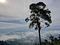
 As viewed from Cameron Highlands
 -

-
 View from Fraser's Hill
 -
 The eastern flank of the Titiwangsa Mountains, as seen from the East Coast Expressway near Karak, Pahang.
 -

-
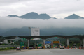
 The Titiwangsa Mountains near Kuala Kubu Baru, Selangor.
 -
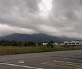
 The Titiwangsa Mountains near Batang Kali, Selangor.
 -
 As seen from a residential skyscraper in Kuala Lumpur
 -
 The Titiwangsa Mountains seen from the North-South Expressway near Seremban, Negeri Sembilan. Visible are Mts. Angsi (the mountain with the darker hue), Berembun and Telapak Buruk (background).
 -
 The Titiwangsa Mountains near Kuala Pilah, Negeri Sembilan.
 -
 The southern section of the Titiwangsa Mountains in Kota, Negeri Sembilan. Mount Datuk rises to the east, which is on the right side of the picture.
 -
 Mount Tampin, Negeri Sembilan, the southern terminus of contiguous Titiwangsa Mountains. Taken at Pulau Sebang, Malacca


.jpg)


References edit
- ^ Racey, Andrew (2009). "Mesozoic red bed sequences in SE Asia and the significance of the Khorat Group of NE Thailand". In Buffetaut, Eric (ed.). Late Palaeozoic and Mesozoic Ecosystems in SE Asia. Geological Society of London. p. 46. ISBN 9781862392755. Retrieved 20 June 2019.
- ^ Metcalfe, I., 2000, "The Bentong-Raub Suture Zone", Journal of Asian Earth Sciences, v. 18, p. 691-712
- ^ Metcalfe, I., 2002, "Permian tectonic framework and palaeogeography of SE Asia", Journal of Asian Earth Sciences, v. 20, p. 551-566
- ^ Ada kebarangkalian gempa bumi berlaku di Malaysia - NRECC astroawani.com 19 April 2023
- ^ "Earthquakes in Malaysia: Should we be worried and how to reduce its impact on our buildings?". 12 January 2022.
- ^ "Gempa bumi: Rujuk peta bahaya seismik sebelum reka bangunan". 2 May 2023.
- ^ Avijit Gupta, The Physical Geography of Southeast 0Asia, Oxford University Press, 2005. ISBN 978-0-19-924802-5
- ^ "Places of Interest | Official Portal of Tampin District Council (MDT)". Mdtampin.gov.my. 1941-01-14. Retrieved 2023-04-04.
- ^ "(PDF) Vegetation of Peninsular Malaysia". Retrieved 3 March 2024.
- ^ "Empat kawasan di Melaka berpotensi diiktiraf Geopark Kebangsaan". Astro Awani. 2023-10-22.
- ^ "Gunong Ulu Titi Basah, Thailand - Geographical Names, map, geographic coordinates". geographic.org. Retrieved 3 March 2024.