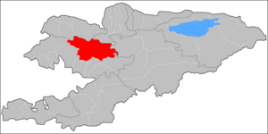
Toktogul (Kyrgyz: Токтогул району) is a district of Jalal-Abad Region in western Kyrgyzstan. The administrative seat lies at Toktogul.[1] Its area is 7,815 square kilometres (3,017 sq mi),[2] and its resident population was 103,310 in 2021.[3]
Toktogul
Токтогул району | |
|---|---|
 | |
 | |
| Country | Kyrgyzstan |
| Region | Jalal-Abad Region |
| Area | |
| • Total | 7,815 km2 (3,017 sq mi) |
| Population (2021) | |
| • Total | 103,310 |
| • Density | 13/km2 (34/sq mi) |
| Time zone | UTC+6 |
The town and district are named after its most famous son - the musician Toktogul Satylganov. The Toktogul reservoir is a geographical feature of the district and the capital lies on the north shore.
Geography edit
The district is located in the southern part of the region within the Naryn river valley. It is bordered by Talas Alatau and Suusamyr Too on the north, At-Oynok Range on the west, and by complex system of mountains: Babash-Ata, Fergana Range and Kekirim-Too on the south. Mountain areas are characterized by highly dissected topography. Absolute elevations of ranges reach 4,165m (Uzun-Akhmat mountains) and 4351 m (Kekirim-Too). The valley is at 650-850 m above sea level. Mountains occupy 93%, and valley - 7% of the district. The hydrology is dominated by Naryn river, Torkent river, Uzun-Akhmat river, and Kara-Suu river. The Toktogul reservoir and partially Kurpsai reservoir are respectively in the center and south-west part of the district. [4]
Climate edit
An average temperature in January is -8°C in valleys, and -12°C in mountains. In July, an average temperature varies from +26°C in valleys, to +8°C in mountains. An absolute recorded temperature minimum was -38° and maximum - +38°. Average yearly precipitation is 400 mm in valleys, and 400-600 mm in mountains. Daily maximum of precipitation can reach 40 mm in valleys and 70 mm in mountains.[4]
Population edit
| Year | Pop. | ±% p.a. |
|---|---|---|
| 1970 | 47,024 | — |
| 1979 | 55,711 | +1.90% |
| 1989 | 69,323 | +2.21% |
| 1999 | 77,202 | +1.08% |
| 2009 | 86,306 | +1.12% |
| 2021 | 103,310 | +1.51% |
| Note: resident population; Sources:[2][3] | ||
Cities, rural communities and villages edit
In total, Toktogul District includes 1 city and 49 settlements in 10 rural communities (ayyl aymagy). Each rural community can consist of one or several villages. The rural communities and settlements in the Toktogul District are:[1][5][6]
- city Toktogul
- Abdy Süyörkulov (seat: Torkent; incl. Kötörmö and Kara-Jygach)
- Aralbaev (seat: Toluk; incl. Almaluu, Noot and Char-Tash)
- Bel-Aldy (seat: Sary-Sögöt; incl. Bel-Aldy and Korgon)
- Cholpon-Ata (seat: Cholpon-Ata; incl. Ak-Tektir, Balykty, Kara-Künggöy, Kushchu-Suu and Mazar-Suu)
- Jangy-Jol (seat: Jangy-Jol; incl. Aral, Kara-Suu, Komsomol, Kuybyshev and Kyzyl-Tuu)
- Ketmen-Döbö (seat: Terek-Suu; incl. Beke-Chal, Chong-Aryk, Eshsay, Jangy-Aryk and Kyrk-Kazyk)
- Kyzyl-Özgörüsh (seat: Kyzyl-Özgörüsh; incl. Ang-Aryk, Bel-Kara-Suu, Buurakan, Jar-Tash, Kamysh-Bashy, Kongur-Ögüz, Kosh-Tash, Orto-Jon, Chech-Döbö, Shayyk and Ak-Jar)
- Nichke-Say (seat: Nichke-Say; incl. Chorgochu)
- Sary-Kamysh (seat: Birlik; incl. Kötörmö)
- Üch-Terek (seat: Üch-Terek; incl. Jetigen, Kyzyl-Uraan, Sargata and Taktalyk)
Note: Kara-Köl is a town of regional significance of Jalal-Abad Region, and is not part of the Toktogul District.
Kongur-
Ögüz
Suu
Kazyk
References edit
- ^ a b "Classification system of territorial units of the Kyrgyz Republic" (in Kyrgyz). National Statistics Committee of the Kyrgyz Republic. Apr 2023. pp. 27–29.
- ^ a b "2009 population and housing census of the Kyrgyz Republic: Jalal-Abad Region" (PDF) (in Russian). National Statistics Committee of the Kyrgyz Republic. 2010. pp. 13, 17.
- ^ a b "Population of regions, districts, towns, urban-type settlements, rural communities and villages of Kyrgyz Republic" (XLS) (in Russian). National Statistics Committee of the Kyrgyz Republic. 2021. Archived from the original on 10 November 2021.
- ^ a b Мониторинг, прогнозирование опасных процессов и явлений на территории Кыргызской Республики [Monitoring and Forecasting of Natural Hazards in Kyrgyz Republic] (PDF) (in Russian) (18th ed.). Ministry of Emergency Situations of Kyrgyz Republic. 2021. pp. 270–271. Retrieved December 21, 2021.
- ^ List of rural communities of Kyrgyzstan Archived 2010-02-09 at the Wayback Machine
- ^ Law 27 September 2012 No. 168 on the transformation of individual urban settlements of the Kyrgyz Republic and relating them to the category of village or city

