Wikipedia:Graphics Lab/Map workshop/Archive/Mar 2011
Stale edit
Bhutan and World Wars edit
-
 Participants of WWI
 -
 Participants of WWII


Article(s): World war
Request: Change Bhutan to the color grey beacuse it was nuetral during the Wars Spongie555 (talk) 06:35, 2 January 2011 (UTC)
Graphist opinion(s):
EuropeArticleLanguages map edit
I would like to request an edit to the map found under Article (grammar), originally submitted by Nikolik. http://en.wikipedia.org/wiki/Article_(grammar) It has been fixed a few times already. I wish I knew how to edit it myself, but I don't. Basically the Arabic speaking world is currently the lighter shade of blue in the legend, which indicates definite articles only. A new category in the legend needs to be named "definite and diacritically marked indefinite articles." This information is already present in the Wikipedia article that the map is being used for.
Please contact me if there is any issue. Thanks. Rsg70007 (talk) 06:01, 5 December 2010 (UTC)
graphist opinion: This should be a simple photoshop job if all you need is a PNG. The thing is... I got confused reading the article (ahh! Grammar!) Can you just tell me/us which countries need to be changed to what shade of color? Jon C (talk) 23:46, 2 January 2011 (UTC)
elk and moose maps edit
-
 map of elk range currently in use on numerous projects
 -
 map of moose range


Request: I don't really know anything about the processes used to create such a map, but I do know that I have seen elk as far north as Whitehorse, Yukon, which does not appear to be included on this map. So I guess I am asking for some clarification on what data was used to create this map and suggesting that it may need to be updated. I will do some digging of my own to see if I can find some verification. Beeblebrox (talk) 02:28, 14 December 2010 (UTC)
- Well, the Yukon government is issuing hunting permits as far north as Carmacks, [1] so either I am misreading the map or it is inaccurate, I doubt they are issuing permits to hunt elk that don't exist. Beeblebrox (talk) 02:39, 14 December 2010 (UTC)
- Oh dear, I'm afraid the map of the range of the moose has the opposite problem, moose do not live in the rugged coastal areas of Southeast Alaska, here is the Alaska Department of Fish and Game map of the moose range in Alaska [2] (scroll down). It even shows them living on islands that are well offshore. Moose are ok swimmers, but not so good that they could swim all the way out the Aleutian Islands. Beeblebrox (talk) 03:32, 14 December 2010 (UTC)
- I know the origin of this map (althought I didn't upload it). It comes from IUCN red list http://www.iucnredlist.org/apps/redlist/details/818/0. It's part of a work who digitized almost all mammals species' distributions. However, as expected in any big work, they are highly inaccurate when we see a single species. Unfortunately, as far as my knowlegde goes, this is the most accurate map avaiable free and online, and is even accepted in the academy. Several papers in biogeography and macroecology use these maps to draw global patterns. Concluding, unless someone find a regional map, we won't have other choice. (First comment in wikipedia sorry if something is wrong, or english is bad) 201.51.80.146 (talk) 00:35, 3 February 2011 (UTC)
Graphist opinion(s):
- I agree these maps are not very good. Neither provides sources. It's not uncommon for Wikipedia/Commons maps to get away with not providing sources, but they should, same as text on Wikipedia. There are many many obviously inaccurate maps on Wikipedia/Commons, and this seems to be another example. I wouldn't trust it. Some kind of reliable source needs to be found for making a good map. The moose map stands out as clearly wrong to me. It seems to claim there are moose in the Oregon High Desert, Vancouver Island, the Olympic Peninsula, etc etc, but not in Yellowstone and the Tetons. I almost walked into a moose in the Tetons! And there definitely aren't any on the Olympic Peninsula. It also shows moose distribution in the Buffalo and Niagara Falls area, which I can assure you is plain wrong. You could bring up these problems on the talk pages of each map, although I've had little luck in getting results that way. You could bring it up on talk pages for articles that use the maps. The best thing would be to find a reliable source with maps showing the proper distribution. (Okay, I just added comments to the talk page on the moose map at The Commons, http://commons.wikimedia.org/wiki/File:Moose_distribution.png -- and a "disputed accuracy" template. Don't hold your breath though--the file has not been edited in a long time. It's possible the author is long gone) Pfly (talk) 12:19, 15 December 2010 (UTC)
UK postcode map edit
Request: Can someone create an svg map out of this [3]. It's a postcode map of the UK in about 2008. I'm not sure if it's up-to-date. I think it may not be, since it is 120 codes [4], and our article states there are 124 (although the ref appears to be a deadlink). If someone could make an svg from the map I linked to, then we could use it as a template for the surname distribution maps that this website shows [5]. Just do a search for a surname on that site, and see how they show the distribution of names. I'd like to be able to do that in some of our articles. Could someone bang up a map we could use as a template?--Brianann MacAmhlaidh (talk) 11:07, 3 January 2011 (UTC)
Graphist opinion:
Clean up on external map edit
Article(s): Zhao Rugua
Request: I have two halves of a map that need to be cleaned up. Unfortunately, they are each too big to be uploaded to a hosting site, so I can't provide a link for other editors to look at. I plan on adding a smaller version of the complete map to the linked article, but I need the larger version cleaned up first. If anyone is interested in looking at the map, you can contact me via my email, which is accessible through Wikipedia. Just go to my talk page and click the button that looks like a mail box. If the interested editor has email set up, I will email you both halves. Basically, a gray haze needs to be removed from the background and the letters and outlines on the countries need to be darkened. Thank you. Ghostexorcist (talk) 13:47, 4 January 2011 (UTC)
Graphist opinion(s):
Article(s): Navi Mumbai, various others
Request: Please create a map of Navi Mumbai (http://www.navimumbaiindia.com/images/navi_mumbai.jpg, http://www.maharashtratourism.gov.in/mtdc/HTML/MaharashtraTourism/images/MapsofMaharashtra/Mumbai/greater-mumbai.jpg) in SVG. I have tried using OpenStreetmap, but since I am not good with vector graphics, I have not been able to produce a good map for this city which requires one.) --92.3.157.210 (talk) 15:31, 4 January 2011 (UTC)
Flag-map of the world edit
-
 Flag-map of the world

Article(s): Quite a few
Request: In the small previews, only Southeast Asia and Australia are visible. I used the same method to make each country so I don't know the cause.
If it helps you to determine the cause, the versions of this file prior to October 2010 only have the US missing (they're outdated though). Transparent 6lue (talk) 22:50, 12 January 2011 (UTC)
Graphist opinion(s):
Veracruz, Mexican State edit
-
 Image A
 -
 Image B
 -
 Image C
 -
 Image D
 -
 Image E
 -
 Image F


Article(s): Veracruz and Municipalities of Veracruz and derivated articles for each city/municipality
Request: Hi I would like to have an image like Image D but for the State of Veracruz (ignoring the infobox in Image D). Actually my main concerns are:
- The size of Image A (2.05MB) when i see images like E (432KB) or F (123KB). If you could give me reduced version of this image I can do all the rest.
- Missing municipality on Image A and B: in Image B, the Municipality in darker blue is Playa Vicente (number 21 of Image C) which wrongly includes Santiago Sochiapan (number 22 Image C) within its borders, if it could be added to a reduced version of Image A, there is no need to create an image similar to Image D, i could take care of it.
Thank you very much. (Sorry to be repetitive, but just a reduced file size would make my day and I could start creating derivative maps after having it) EOZyo (мѕğ) 07:28, 16 January 2011 (UTC)
Graphist opinion(s):
- The size is in the details - image A contains polygons for all municipalities, which takes up much more data than just drawing all states of Mexico. Technically, a less precise version of A (i.e. one with less nooks and corners of all municipalities displayed) would suffice, but that's a lot of work. With a regular image, you could use graphical software to smooth the lines, but since every line is actually two edges of neighbouring municipalities, automatic smoothing gives unsatisfactory results... Sorry. Is the big file size a problem, though? Classical geographer (talk) 10:53, 20 January 2011 (UTC)
Rally Dakar edit
Article(s): 1979 Paris–Dakar Rally and others from Template:Dakar_Rally
Request:Hello, please create maps of all years Dakar Rally in same style like 2010 and 2011 (easy-translate SVG with all route). Sources are here [6] and here [7]. Thanks. Slfi (talk) 16:59, 17 January 2011 (UTC)
Graphist opinion(s): That's a lot of work, Slfi. Makes it worth your while to have a go yourself with Inkscape, maybe, if someone here provides you with a map showing France, Spain and NW-Africa? Classical geographer (talk) 10:49, 20 January 2011 (UTC)
Transilien P edit
Article(s): Transilien Paris – Est, Ligne P du transilien on the french wikipedia and the future article Transilien lijn P on the dutch wikipedia
Request: Could you make a map of line P of the transilien-network? Resources can be found here and here. Aliesperet (talk) 17:25, 19 January 2011 (UTC)
Graphist opinion:
- There is no map at all of any Transilien service. I think that would be a first priority; either a schematic map (as on the official Transilien website here) or one overlaid over a map of Paris - which would have the advantage of showing more clearly that Transilien services reach somewhat further out than the RER network. Aliesperet, what do you say? Classical geographer (talk) 10:45, 20 January 2011 (UTC)
Requester's Answer Than, if possible, an overlaid map which would have the advantage of showing more clearly that Transilien services reach somewhat further out than the RER network. — Preceding unsigned comment added by Aliesperet (talk • contribs) 20:13, 23 January 2011 (UTC)
Resolved edit
Axial Seamount edit
-
 Position of Axial Seamount on the Juan de Fuca ridge.

Article(s): Axial Seamount
Request: Cleanup, wikify, vectorize, crop the title at the top. Prospective GA. Thanks, ResMar 02:55, 11 October 2010 (UTC)
Graphist opinion(s): ![]() Done Jon Chui (talk) 02:55, 28 December 2010 (UTC)
Done Jon Chui (talk) 02:55, 28 December 2010 (UTC)

Iran–Bolivia relations edit

Article(s): Iran–Bolivia relations
Request: Need an introductory map akin to Iran - Ecuador relations. Thanks again for all your hard work.Lihaas (talk) 07:54, 28 October 2010 (UTC)
Graphist opinion(s):
![]() Done Wereldburger758 (talk) 06:29, 31 October 2010 (UTC)
Done Wereldburger758 (talk) 06:29, 31 October 2010 (UTC)
-
 SVG background to use
 -
 Flag protesters
 -
Flag of loyalists
-
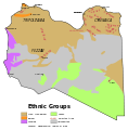 Ethnic, may be useful
 -
 Regions, may be useful to enlighten them by a bold border line


Article(s): 2011 Libyan protests. Source: dailymail.co.uk
Request: Hello. The map about the ongoing Libyan protest will need frequent edit. Thus, the SVG format is really encouraged. I collected all tools, the need is to redo the jpg map into SVG format. As a secondary thing, both the ethnic map and density map are relevant, either to include, either to redo as separate files based on File:Libya location map.svg. Who take it ? 140.120.55.63 (talk) 09:55, 24 February 2011 (UTC)
- File:LibyanCivilWar.jpg isn't based on either any identifiably free maps nor on verifiable references, so it shouldn't be used for anything, least of all should it appear in article space. Somebody should try and compile a map of the current situation in Libya, but it should be based on a free map, and the information shown should be derived from some verifiable source. --dab (𒁳) 15:54, 24 February 2011 (UTC)
- I added a source ! Yug 08:34, 26 February 2011 (UTC)
Graphist opinion(s): Completed elsewhere. Kmusser (talk) 00:21, 28 February 2011 (UTC)
Create Korea (orthographic projection).svg edit
-

-

-
 Upload under this name

.svg)
.svg)
Article(s): Korea
Request: Please create an orthographic map of Korea. Thanks P. S. Burton (talk) 20:38, 26 February 2011 (UTC)
Graphist opinion(s):
 Done sorry, got the name wrong when uploading. A rename request to the correct name should be fulfilled soon by an admin. gringer (talk) 02:47, 27 February 2011 (UTC)
- Thank you. P. S. Burton (talk) 12:03, 27 February 2011 (UTC)
Iraqi Kurdish Civil War edit
-
 Please convert to svg

Article(s): Kurdistan Islamist Conflict, 2008 Turkish incursion into northern Iraq, Iraqi Kurdish Civil War
Request: DPlease convert to svg. P. S. Burton (talk) 15:31, 24 February 2011 (UTC)
Graphist opinion(s):
 Request taken by rossche.: I'll do it. rosschétalké 10:56, 9 March 2011 (UTC)
- Done rosschétalké 01:11, 10 March 2011 (UTC)

Siege of Valencia edit
-
 Please redraw as svg.
 -
 svg
svg


Article(s): Siege of Valencia (1812)
Request: Please redraw as svg P. S. Burton (talk) 22:46, 1 March 2011 (UTC)
Graphist opinion(s):
- Request taken by rossche.: It looks like none working on this map, I'll give it a try. rosschétalké 21:45, 8 March 2011 (UTC)
- Done: svg it is. If there's something I missed, please let me know ;) rosschétalké 02:50, 9 March 2011 (UTC)
- Looks great. Thank you very much. P. S. Burton (talk) 23:11, 21 March 2011 (UTC)
Map of USA with state names.svg needs a more detailed/robust font-family in source SVG edit
-
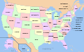 A compass of the United States, with state names.

Article(s): Political_divisions_of_the_United_States
Request: In the source of the file, replace:
font-family:Nimbus Sans L
with:
font-family:'Arial Narrow','Nimbus Sans L',sans-serif;"
This makes the source SVG map more readable where "Nimbus Sans L" is not installed. Tested on a local copy.
Graphist opinion(s): Made the font bold. What do you think about that? Wereldburger758 (talk) 07:18, 22 February 2011 (UTC)
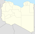
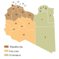
Old regions of Libya edit
-

-
 Et voilà ;)


Article(s): Cyrenaica, Tripolitania, Fezzan
Request: Please create English version of this file. Gryffindor (talk) 07:42, 27 February 2011 (UTC)
Graphist opinion(s):
![]() Done Bourrichon (talk) 13:00, 16 March 2011 (UTC)
Done Bourrichon (talk) 13:00, 16 March 2011 (UTC)
Invasion of Anjouan edit
-
 Please redraw as svg, and ad an insert showing the islands position in relation to Africa.
 -
 french (original)
 -
 topo in english
 -
 the invasion (more accurate than in the raster one).


Article(s): 2008 invasion of Anjouan
Request: Please redraw as svg, and ad an insert showing the islands position in relation to Africa. Thank. P. S. Burton (talk) 15:46, 2 March 2011 (UTC)
Graphist opinion(s): Note : there is the same request at the french atelier graphique. Bourrichon (talk) 16:45, 7 March 2011 (UTC)
![]() Request taken by Bourrichon.
Request taken by Bourrichon.
![]() Done, but could you check my english translation ? ;) Bourrichon (talk) 16:37, 15 March 2011 (UTC)
Done, but could you check my english translation ? ;) Bourrichon (talk) 16:37, 15 March 2011 (UTC)
- Thank you very much. It looks great. The English translations looks fine to me, but unfortunately I don't have the expertise to be sure. P. S. Burton (talk) 23:09, 21 March 2011 (UTC)
Borders of future Principlity of Albania, proposed by the Provisional Government of Albania in 1913 edit

Article(s): Albanian Vilayet, Provisional Government of Albania and Principality of Albania
Request: Please create a map with borders of future Principlity of Albania, proposed by the Provisional Government of Albania in 1913. There is a map on the page number 20 in the book of Kostandin Cerkezi, "Albania, Past and Present"Antidiskriminator (talk) 18:30, 19 March 2011 (UTC)
- I have created this one based on this map [[8]], it sounds much more neutral than Cerkezi [[9]]. Tell me your suggestions about it.Alexikoua (talk) 09:52, 21 March 2011 (UTC)
- First, I would like to thank you for your efforts. I really appreciate it. I also think that Cerkezi is not a neutral source. It is interesting that the map he drawn is much different than map you provided. Please find my suggestions below:
- In the source section of the image you provided, there is only a link to some web site without details of the source (title of the work, author,...). Are there more details about the source you used?
- It would be good to have some legend explaining what is what, i.e. in the left corner of the image
- The line of the northern frontier fixed by Ambassadors Conference and Boudary Commission 1912-1914 is not drawn according to the source you provided. In the source it goes only downwards after leaving Montenegrin border before reaching Greece
- Towns like Peć, Đakovica, Prizren and all other present in the original source's map should be present in the image too. Not only because it is more informative that way, but because it looks much nicer.
The image would look nicer without thick black and grey lines that are not necessary since there are different colors of the areas proposed by different sides, provided that area of Albania proposed by Russia and France is presented in different color.
- First, I would like to thank you for your efforts. I really appreciate it. I also think that Cerkezi is not a neutral source. It is interesting that the map he drawn is much different than map you provided. Please find my suggestions below:
- I have created this one based on this map [[8]], it sounds much more neutral than Cerkezi [[9]]. Tell me your suggestions about it.Alexikoua (talk) 09:52, 21 March 2011 (UTC)
That is all for now. Once again, thank you very much for your assistance.--Antidiskriminator (talk) 16:12, 21 March 2011 (UTC)
- The map is sourced from the United States of America Department of State, National Archives College Park, so I feel it's the best we have. Tell me if something still needs to be fixed.Alexikoua (talk) 21:28, 24 March 2011 (UTC)
- Thank you very much. I am very satisfied. Thank you.--Antidiskriminator (talk) 21:54, 24 March 2011 (UTC)
- The map is sourced from the United States of America Department of State, National Archives College Park, so I feel it's the best we have. Tell me if something still needs to be fixed.Alexikoua (talk) 21:28, 24 March 2011 (UTC)
Translation of the serbian cyrilic inscription on the map edit


Request: Would somebody be so kind to create new image with translated serbian cyrilic inscriptions on this image to English:
- Велика Југославија - Great Yugoslavia
- Балканска Федерација - Balkan Federation
- Проширена варијанта Балканске федерације - Expanded version of Balkan Federation
Thanks.--Antidiskriminator (talk) 20:56, 23 March 2011 (UTC)
Graphist opinion(s): ![]() Request taken by Fallschirmjäger. 14:09, 24 March 2011 (UTC)
Request taken by Fallschirmjäger. 14:09, 24 March 2011 (UTC)
- Done - Map translated to English. Regards, Fallschirmjäger ✉ 16:52, 24 March 2011 (UTC)
- Thank you very much.--Antidiskriminator (talk) 17:11, 24 March 2011 (UTC)
- нема проблема :) Fallschirmjäger ✉ 18:59, 24 March 2011 (UTC)
- Thank you very much.--Antidiskriminator (talk) 17:11, 24 March 2011 (UTC)
2009 Russia–Ukraine gas dispute edit
-
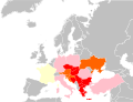 Countries of Europe gas supply to which was disrupted during Russia-Ukraine gas disputes in 2009

Article(s): 2009 Russia–Ukraine gas dispute
Request: The current map is incorrect as it shows incorrect data concerning several countries (e.g. Turkey, Ukraine). The correct map is located at http://ec.europa.eu/commission_2010-2014/president/news/documents/pdf/energy_en.pdf, page 7. I would like to ask to update the existing map accordingly. Beagel (talk) 10:12, 8 March 2011 (UTC)
Graphist opinion(s): ![]() Done: Recoloured Chipmunkdavis (talk) 07:16, 26 March 2011 (UTC)
Done: Recoloured Chipmunkdavis (talk) 07:16, 26 March 2011 (UTC)
"Zooming in" on the Gulf to see members of the Gulf Cooperation Council edit
-
 Map showing which nations are members of the Gulf Cooperation Council

Article(s): Gulf Cooperation Council
Request: Please redo the map so that it shows only the Gulf region. The six member nations need to be clearly recognizable (Bahrain, Kuwait, Qatar, Saudi Arabia, Oman, United Arab Emirates), and including the entire world frustrates this basic function. Wareh (talk) 00:06, 18 March 2011 (UTC)
Graphist opinion(s): There's already a crop available listed on that image page, File:Gulfrugby.png, would that work? Kmusser (talk) 14:39, 18 March 2011 (UTC)
- Thanks for the reply; I had not understood what you've pointed out. I've substituted this cropped image at the article, but it's quite pixelated (the cropped image is just 132x123), so it would still be desirable to replace it with an image with the appropriate resolution to be viewed at this closeness. Surely we have a high enough resolution generic world/region map to provide better than 132x123 of this region? Wareh (talk) 14:48, 18 March 2011 (UTC)
- (Actually, it's been here at English Wikipedia since 2008; but someone found it yesterday, moved it to Commons, and used it at the article. So we're good.) Wareh (talk) 19:15, 26 March 2011 (UTC)– by the creation today of commons:File:Persian Gulf Arab States english.PNG. Wareh (talk) 02:40, 26 March 2011 (UTC)
 Resolved
Ü-Tsang edit


.svg)
![[3]](http://gbnames.publicprofiler.org/help/..%5Cimages%5CUKpostarea.png)
![[8]](http://www.informaworld.com/ampp/image?path=/713634951/771302998/fdps_a_216231_o_f0001g.gif)
Article(s): Ü-Tsang
Request: It's interesting, but can we make it more encyclopedic? and png or svg?... Kintetsubuffalo (talk) 03:26, 28 January 2011 (UTC)
Graphist opinion(s): ![]() Request taken by kmusser. I should have something for this soon.
Request taken by kmusser. I should have something for this soon.
- How does this look? Kmusser (talk) 21:37, 27 March 2011 (UTC)
- Yeah! That's much better! Thank you!--Kintetsubuffalo (talk) 01:25, 28 March 2011 (UTC)