
File:GolanHistoricalBorders.svg

Size of this PNG preview of this SVG file: 374 × 599 pixels. Other resolutions: 150 × 240 pixels | 300 × 480 pixels | 479 × 768 pixels | 639 × 1,024 pixels | 1,279 × 2,048 pixels | 534 × 855 pixels.
Original file (SVG file, nominally 534 × 855 pixels, file size: 54 KB)
| This is a file from the Wikimedia Commons. Information from its description page there is shown below. Commons is a freely licensed media file repository. You can help. |
Summary
| Description |
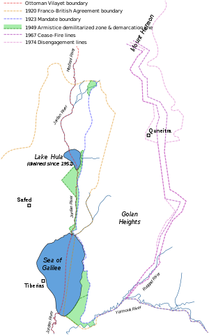
Historical Golan Heights boundaries:
1974 Disengagement lines. |
| Date | |
| Source |
Self-made, based on:
|
| Author | Doron |
Licensing
I, the copyright holder of this work, hereby publish it under the following license:

|
Permission is granted to copy, distribute and/or modify this document under the terms of the GNU Free Documentation License, Version 1.2 or any later version published by the Free Software Foundation; with no Invariant Sections, no Front-Cover Texts, and no Back-Cover Texts. A copy of the license is included in the section entitled GNU Free Documentation License. |
| This file is licensed under the Creative Commons Attribution-Share Alike 3.0 Unported license. | ||
| ||
| This licensing tag was added to this file as part of the GFDL licensing update. |
File history
Click on a date/time to view the file as it appeared at that time.
| Date/Time | Thumbnail | Dimensions | User | Comment | |
|---|---|---|---|---|---|
| current | 09:38, 3 August 2011 | | 534 × 855 (54 KB) | Doron | 1949 Armistice demarcation line |
| 08:49, 14 October 2007 |  | 534 × 855 (52 KB) | Doron | correct 1967/1974 lines | |
| 10:00, 17 September 2007 |  | 534 × 855 (50 KB) | Doron | fix | |
| 09:58, 17 September 2007 |  | 534 × 855 (50 KB) | Doron | background | |
| 08:57, 17 September 2007 |  | 534 × 855 (50 KB) | Doron | ||
| 08:54, 17 September 2007 |  | 534 × 855 (51 KB) | Doron | {{Information |Description= |Source=self-made |Date= |Author= Doron }} |
File usage
The following pages on the English Wikipedia use this file (pages on other projects are not listed):
Global file usage
The following other wikis use this file:
- Usage on ar.wikipedia.org
- Usage on ca.wikipedia.org
- Usage on ckb.wikipedia.org
- Usage on de.wikipedia.org
- Usage on es.wikipedia.org
- Usage on fa.wikipedia.org
- Usage on fr.wikipedia.org
- Usage on he.wikipedia.org
- Usage on id.wikipedia.org
- Usage on it.wikipedia.org
- Usage on ko.wikipedia.org
- Usage on ky.wikipedia.org
- Usage on mzn.wikipedia.org
- Usage on nl.wikipedia.org
- Usage on ru.wikipedia.org
- Usage on sv.wikipedia.org
- Usage on tg.wikipedia.org
- Usage on tr.wikipedia.org
- Usage on uk.wikipedia.org
- Usage on www.wikidata.org