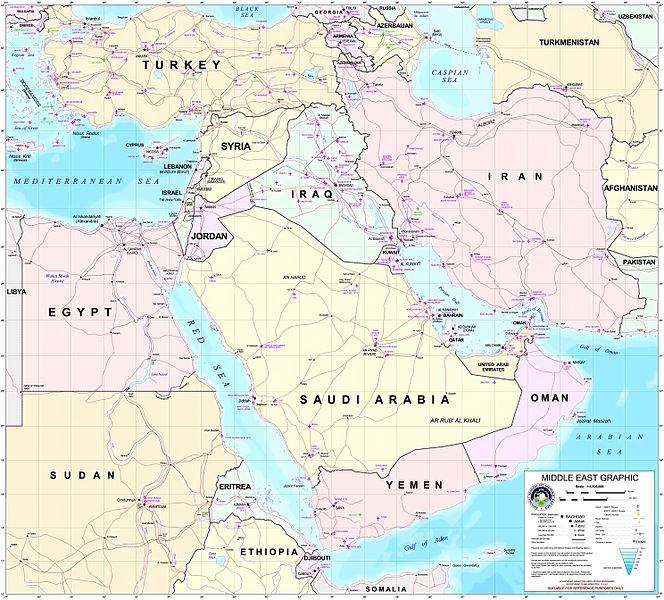
File:Middle east graphic 2003.jpg

Size of this preview: 664 × 600 pixels. Other resolutions: 266 × 240 pixels | 532 × 480 pixels | 850 × 768 pixels | 1,134 × 1,024 pixels | 2,268 × 2,048 pixels | 2,973 × 2,685 pixels.
Original file (2,973 × 2,685 pixels, file size: 3.91 MB, MIME type: image/jpeg)
File history
Click on a date/time to view the file as it appeared at that time.
| Date/Time | Thumbnail | Dimensions | User | Comment | |
|---|---|---|---|---|---|
| current | 22:30, 8 February 2012 |  | 2,973 × 2,685 (3.91 MB) | M0tty | Remove compression artefacts by a bilateral filtering. |
| 21:43, 14 July 2006 |  | 2,973 × 2,685 (1,013 KB) | Unquietwiki | ''Courtesy of the University of Texas Libraries, The University of Texas at Austin'' [http://www.lib.utexas.edu/maps/middle_east.html http://www.lib.utexas.edu/maps/middle_east.html] High-resolution political / railway / roadmap of the Middle East. |
File usage
More than 100 pages use this file. The following list shows the first 100 pages that use this file only. A full list is available.
- Al-Qabisi
- Julianus ben Sabar
- Wasil ibn Ata
- Talk:Akrotiri and Dhekelia
- Talk:Aladdin
- Talk:Ali Hassan al-Majid
- Talk:Anan ben David
- Talk:Ancient Egyptian religion
- Talk:Antiphonitis
- Talk:Arab world
- Talk:Arabian Peninsula
- Talk:Arabic
- Talk:Azerbaijan
- Talk:Bahrain
- Talk:Biryani
- Talk:Black Sea
- Talk:Black Sea deluge hypothesis
- Talk:Caucasian race
- Talk:Crusader states
- Talk:Cypriot Greek
- Talk:Cyprus
- Talk:Daniel Pipes
- Talk:Dhow
- Talk:Dubai
- Talk:Egypt
- Talk:Emirate of Fujairah
- Talk:Epic of Gilgamesh
- Talk:Esau
- Talk:Europe, the Middle East and Africa
- Talk:Flag of Northern Cyprus
- Talk:Gaza City
- Talk:Gaza Strip
- Talk:Geography of Iran
- Talk:Geography of the West Bank
- Talk:George Michael
- Talk:Georgia (country)
- Talk:Gilgamesh
- Talk:Golan Heights
- Talk:Greeks
- Talk:Gulf Air
- Talk:Gulf Arabic
- Talk:Gulf War
- Talk:Gulf War (disambiguation)
- Talk:Highway of Death
- Talk:Historicity of the Bible
- Talk:History of Cyprus
- Talk:History of Iran
- Talk:History of Kuwait
- Talk:History of the Middle East
- Talk:Iram of the Pillars
- Talk:Iran–Iraq War
- Talk:Isaac Komnenos of Cyprus
- Talk:Israel
- Talk:Jews
- Talk:Joseph Stalin
- Talk:Keffiyeh
- Talk:Knights Templar
- Talk:Kurdistan
- Talk:Kuwait
- Talk:Kuwaiti dinar
- Talk:Kuwaiti oil fires
- Talk:Land of Israel
- Talk:Lebanon
- Talk:Madhhab
- Talk:Mesopotamia
- Talk:Middle Eastern cuisine
- Talk:Mount Herzl
- Talk:Muscat
- Talk:Music of Kuwait
- Talk:Music of Oman
- Talk:Northern Cyprus
- Talk:Nostratic languages
- Talk:Oman
- Talk:Palestine (region)
- Talk:Palestinian National Authority
- Talk:Palestinian territories
- Talk:Persian language
- Talk:Persian literature
- Talk:Phoenicia
- Talk:Ramallah
- Talk:Ramzi Yousef
- Talk:Romani people
- Talk:Rub' al Khali
- Talk:SOAS University of London
- Talk:Saudi Arabia
- Talk:Second Gulf War
- Talk:Shawarma
- Talk:State of Palestine
- Talk:Strait of Hormuz
- Talk:Suez Canal
- Talk:Swahili language
- Talk:Syria
- Talk:Syriac language
- Talk:U.S. list of most-wanted Iraqis
- Talk:Unani medicine
- Talk:United Arab Emirates
- Talk:West Asia
- Talk:West Bank
- Talk:Za'atar
- Talk:Zoroastrianism
View more links to this file.
Global file usage
The following other wikis use this file:
- Usage on ar.wikipedia.org
- ويكيبيديا:قوالب/بذور
- ويكيبيديا:قوالب/بذور/جدول بذرة 1
- قالب:بذرة جغرافيا الشرق الأوسط
- بادية الشام
- محافظة العاصمة (البحرين)
- خليج عدن
- دزفول
- زاغروس
- مسجد سليمان
- زاينده
- مسرح أحداث الشرق الأوسط خلال الحرب العالمية الثانية
- الحويزة (مدينة)
- قائمة جزر الخليج العربي
- شرق المتوسط
- قائمة نزاعات الشرق الأوسط الحديثة
- مستخدم:Adnanzoom/مساعدات
- عبد الله بن سعيد
- قرار مجلس الأمن التابع للأمم المتحدة رقم 1381
- مستخدم:ASammour/بذرة-بوابة
- شرف الدين بن الحسن
- فخر الدين بن عدي
- صخر بن صخر بن مسافر
- قالب:بذرة أعلام الشرق الأوسط
- أبجر التاسع
- Usage on arz.wikipedia.org
- Usage on ba.wikipedia.org
- Usage on be.wikipedia.org
- Usage on bn.wikipedia.org
- Usage on ca.wikipedia.org
- Usage on ce.wikipedia.org
- Usage on ckb.wikipedia.org
- Usage on el.wikipedia.org
- Usage on es.wikipedia.org
- Usage on fa.wikipedia.org
- Usage on fiu-vro.wikipedia.org
- Usage on fi.wikivoyage.org
- Usage on fo.wikipedia.org
- Usage on fr.wikipedia.org
- Usage on gag.wikipedia.org
- Usage on gl.wikipedia.org
- Usage on he.wikipedia.org
View more global usage of this file.


