This article is within the scope of WikiProject Israel, a collaborative effort to improve the coverage of Israel on Wikipedia. If you would like to participate, please visit the project page, where you can join the discussion and see a list of open tasks.IsraelWikipedia:WikiProject IsraelTemplate:WikiProject IsraelIsrael-related articles
The contentious topics procedure applies to this article. This article is related to the Arab–Israeli conflict, which is a contentious topic. Furthermore, the following rules apply when editing this article:
You must be logged-in and extended-confirmed to edit or discuss this topic on any page (except for making edit requests, provided they are not disruptive)
You may not make more than 1 revert within 24 hours on any edits related to this topic
The exceptions to the extended confirmed restriction are:
Non-extended-confirmed editors may use the "Talk:" namespace only to make edit requests related to articles within the topic area, provided they are not disruptive.
Non-extended-confirmed editors may not create new articles, but administrators may exercise discretion when deciding how to enforce this remedy on article creations. Deletion of new articles created by non-extended-confirmed editors is permitted but not required.
With respect to the WP:1RR restriction:
Clear vandalism of whatever origin may be reverted without restriction. Also, reverts made solely to enforce the extended confirmed restriction are not considered edit warring.
Editors who violate this restriction may be blocked by any uninvolved administrator, even on a first offence.
I've noticed that you've quoted Ilan Pappe quite a number of times as a source for your article. I'm just wondering if that is considered okay according to Wikipedia, because he is considered a controversial historian and his views are considered to be by many as POV. To quote from his wikipedia page "He is one of the "New Historians" who have re-examined and hold controversial views of the history of Israel and of Zionism." Leppi 08:56, 31 August 2007 (UTC)[reply]
Almost EVERYBODY cited as a reference in this artice is an Israeli. With conflicts involving at least 4 countries, Syria, Egypt, Lebanon, and Jordan, how credible is an article that uses as sources just ONE group's opinions? Surely, there is built in POV there without more. —Preceding unsigned comment added by 69.109.114.161 (talk) 06:09, 19 May 2008 (UTC)[reply]
A recent edit states that "The border segment from Ein Gedi to Beit She'an was not marked, because Jordan said that the Palestinian Authority should be a partner for setting this border." - This is unsourced, and appears to contradict the sourced statement in the next sentence, which says "Upon the official signing of the Israel-Jordan Treaty of Peace, the Jordan and Yarmouk Rivers, the Dead Sea, the Emek Ha'arva/Wadi Araba and the Gulf of Aqaba were officially designated as the borders between Israel and Jordan. " I am therefor removing the unsourced addition. Canadian Monkey (talk) 14:52, 24 June 2008 (UTC)[reply]
I understand the point you're trying to make, but the way you've worded it is incorrect (Beit Shean is more than 10 Km north of the end of that segement, and 5Km to the west) as well as confusing. I'll take a stab, using the language from the treaty itself. Canadian Monkey (talk) 23:18, 24 June 2008 (UTC)[reply]
That works. The En Gedi part has clear support in this more complete version of the document[1] though. The border is left undefined north of 31 29 35 N, and the nearest populated place on the map is in fact En Gedi. I have not been able to track down the actual treaty maps yet (that was harder than I had imagined) but as soon as I find the documentation, I put back Beit She'an as the northern extreme of the undefined prt of the border. MeteorMaker (talk) 06:47, 25 June 2008 (UTC)[reply]
There is another Israel which isn't been mentioned in this article, despite it's immense (and very threatening) importance in the eyes of 100s of millions of people. It's the Zionist dream of "From the Nile to the Euphrates". It's not paranoia by Arafat, it's central to the project. (Actually, it predates Zionism by over 2000 years, God promises Abraham in Genesis 15:18 "To your descendants I give this land from the River of Egypt to the Great River, the river Euphrates.". Moses promises his descendants in Deuteronomy 11:24 that "every place where you set the soles of your feet shall be yours. Your borders shall run from the wilderness to the Lebanon and from the River, the river Euphrates, to the western sea.")
From the Nile to the Euphrates was there right at the beginning of Zionism - in 1898, Theodore Herzl planned to ask the Ottoman sultan for a territory stretching from the Egyptian frontier to the Euphrates.[1] He and Isidore Bodenheimer regularily spoke of Jewish settlement in "Palestine and Syria". So did the Jewish National Fund and the Zionist Congress. In 1902, Herzl spoke of settling Jews in Mesopotamia.
Jabotinsky is quoted in 1935 saying "We want a Jewish Empire".[2] The Stern Gang's 18 principles in 1940 included "from the brook of Egypt to the great river, the river Euphrates" David Ben-Gurion in 1954 "the border of Israel will be where the army takes it", Moshe Dayan spoke of expansion to Babylon and the Euphrates as he stood on the Golan Heights for the first time in 1967.[3][4]
Menachem Begin reminded Israelis that the Bible says the Israeli state will include portions of Iraq, Syria, Turkey, Saudi Arabia, Egypt, Sudan, Lebanon, Jordan and Kuwait.[5]
And some Western sources were open about the same thing - British Ambassador to Istanbul "the domination of Egypt, the land of the Pharaohs, who forced the Jews to build Pyramids, is part of the future heritage of Israel."[6]
^Theodor Herzl, Zionistisches Tagebücher, 1895-1899, edited by Johannes Wachten, Chaya Harel, et al. (Berlin: Ullstein, 1983), vol. 2, p. 650. For a catalogue of Zionist and Israeli statements, real and alleged, see Ass'ad Razzouq, Greater Israel: A Study in Zionist Expansionist Thought (Beirut: Palestine Liberation Organization Research Center, 1970), especially pp. 83, 87-90, 92, 96-97, 99-103, 144-45, 167-69, 178-81, 187, 209, 212-14, 230, 234, 240, 243-45, 249-52, 264, 278-82, 286.
^Robert Gessner, "Brown Shirts in Zion," New Masses, Feb. 19, 1935, p. 11.
^Sa`d al-Bazzaz, Gulf War: The Israeli Connection, transl. Namir Abbas Mudhaffer (Baghdad: Dar al-Ma'mun, 1989).
^Tyler Courier-Times-Telegraph, 5 Feb. 1983; reported in The Los Angeles Times, Feb. 6, 1983.
^Secret letter from Gerard Lowther to Charles Hardinge, 29 May 1910, Foreign Office 800/193A (Lowther Papers). Quoted in Elie Kedourie, Arabic Political Memoirs and Other Studies (London: Frank Cass, 1974), p. 256.
All the above, including the references, comes from the very pro-Israel blogger and self-publisher (?) Daniel Pipes, along with a number of maps. I don't know whether we'd accept what he claims, that it's all there in the RS too. PRtalk 18:04, 6 August 2008 (UTC)[reply]
Is there a change you'd like to propiose to the article, or is this yet another one of your endless soapboxes? Canadian Monkey (talk) 18:17, 6 August 2008 (UTC)[reply]
Image copyright problem with Image:Shebaafarms.png[edit]
The image Image:Shebaafarms.png is used in this article under a claim of fair use, but it does not have an adequate explanation for why it meets the requirements for such images when used here. In particular, for each page the image is used on, it must have an explanation linking to that page which explains why it needs to be used on that page. Please check
That there is a non-free use rationale on the image's description page for the use in this article.
That this article is linked to from the image description page.
The article states that "American President Woodrow Wilson protested British concessions in a cable to the British Cabinet". The only reference for this cable that I could find (except for other Wikipedia articles that use it) was from a political pamphlet [2] by one Meir Abelson, who is not a historian of any standing. Furthermore, he does not provide a source for his quote, which makes it impossible to confirm it and consider its context (which is particularly important given the distinct political slant of his writing). I have been unable to find this quote in the 69 volumes of Arthur S. Link, The Papers of Woodrow Wilson. Unless a more reliable source is provided, I would like to remove this quote. Copies of this message are posted in other Wikipedia articles where this cable is quoted with the hope of finding more information about it.--128.139.104.49 (talk) 13:22, 17 February 2009 (UTC)[reply]
Is there a reason that the consensus state of affairs is not made more clear?
What issues are there perceived with this change? Unomi (talk) 03:05, 9 April 2010 (UTC)[reply]
Even though I agree with what it says, I think it is too strident for the introduction. Also it focuses on just one part of the border whereas the article is supposed to be about all the borders. On the other hand, breen1007's version is entirely useless (what does "The starting-point may be taken" mean and why may it be taken? what secret agreement is being referred to? Picot-Sykes?). Zerotalk 04:15, 9 April 2010 (UTC)[reply]
You are probably right that it sounds too strident. I think though that we should start with what the internationally accepted borders are now, and then deal with the historical evolution of them in the article. Unomi (talk) 04:20, 9 April 2010 (UTC)[reply]
I reverted this part in the lead,[3] since its more accurate and sourced and the previous lead was useless. --Supreme Deliciousness (talk) 09:28, 9 April 2010 (UTC)[reply]
Both versions were fairly bad—one was completely impossible to read (unclear language), while the other was a mess of propaganda combined with more propaganda with the aim of demonizing Israel. I have made some changes to hopefully balance this and give due weight to all the events regarding Israel's borders. Maybe the lead can be expanded, but in that case all of its parts must be expanded (especially how the British Mandate's borders were created, including the cutting off of Transjordan), not the ones about armistice agreements, which had unclear relevance to the Borders of Israel today. —Ynhockey(Talk) 10:58, 9 April 2010 (UTC)[reply]
But don't you think that it would be proper to indicate what is the world consensus regarding the current borders of Israel?Unomi (talk) 11:18, 9 April 2010 (UTC)[reply]
Which ones, the borders with Egypt, Jordan or Lebanon? —Ynhockey(Talk) 11:36, 9 April 2010 (UTC)[reply]
The territory which is internationally recognized to be under Israeli civil law. Unomi (talk) 11:54, 9 April 2010 (UTC)[reply]
I'm not sure what you are referring to. Israel has two borders—with Jordan and with Egypt—and one other border (with Lebanon) that's mostly not subject to dispute (other than the Shebaa Farms dispute). One could also say that there is a border with the Gaza Strip. However, all other borders are subject to final status agreements, i.e. there are no other borders. —Ynhockey(Talk) 11:57, 9 April 2010 (UTC)[reply]
Being subject to final status agreements does not render the previous border null and void, it simply means that after the final status agreements they might be changed. In the interim period between having occupied a territory and negotiated a land transfer the borders remain unchanged though the land is occupied. Unomi (talk) 12:07, 9 April 2010 (UTC)[reply]
The whole world recognizes that Resolution 242 describe what Israels accepted borders are, by way of the green line, and barring any internationally recognized agreements to the contrary that is how they will stay. We see that this notion is upheld by the ICJ, ECJ and indeed the Israeli Supreme court when they refer to the land as occupied. It should not need to be said that occupied land does not fall within your borders. Unomi (talk) 12:15, 9 April 2010 (UTC)[reply]
Ynhockeys edit is unacceptable, he removed the worldview and re inserts unsourced text. --Supreme Deliciousness (talk) 11:30, 9 April 2010 (UTC)[reply]
This sentence is quite unacceptable in the introduction: "The borders had already been agreed in secret by the United Kingdom and France, in preparation for the expected downfall of the Ottoman Empire following World War I." Assuming it refers to the Sykes-Picot agreement, it is misleading because the boundaries indicated in that agreement are nothing like the boundaries of the Mandate for Palestine. For example the Palestine-Lebanon border is much further south than was agreed later, and Negev was part of the "Independent Arab State in the British Sphere of Influence" (a lovely imperial phrase!) which occupied a huge region from the Jordan River to the edge of Kurdistan. Zerotalk 13:10, 9 April 2010 (UTC)[reply]
Regarding official borders, Ynhockey has a point. Boundaries have different degrees of officialness, with the most official type being one specified in a mutual treaty between the states on each side of the boundary. With that strict meaning, only Israel-Egypt and Israel-Jordan (except where the West Bank is between) are official. Israel-Lebanon is close to that status, but I think the most precise statement is that the UN-marked border is accepted by both sides as an interim measure until such time as a mutual treaty makes it official. Regarding the Green Line, the international community (including Israel except for Jerusalem) recognizes current Israeli sovereignty on one side and denies it on the other side, but this is not the same as recognizing the Green Line as a border. Strictly speaking the Green Line is still an armistice line. This interpretation can be argued about and obviously has been; we should cite such argument in the article. Zerotalk 13:28, 9 April 2010 (UTC)[reply]
You are probably right about the text that talks about Sykes–Picot. However, it is also clear that, while the agreement did not demarcate the mandate's final borders, it did create the separation of Palestine from Syria, which had a significant influence on the mandate's borders (and later Israel's). Also, again, I believe it is very important to mention the British separation of Transjordan from Cisjordan. Can you draft a lead section that you believe is acceptable? —Ynhockey(Talk) 13:47, 9 April 2010 (UTC)[reply]
P.S. I would also appreciate it if Unomi stopped making edits that are clearly false. "The internationally-recognized Israeli border is the 1949 armistice line"? Do you mean the border with Jordan? Or is the border with Lebanon called the Green Line? That's what the article currently implies. Let's stick to the facts please. —Ynhockey(Talk) 14:02, 9 April 2010 (UTC)[reply]
P.P.S. The source which Unomi used that supposedly supports her claims does not actually support it. This is a clear violation of policy, and I ask Unomi to self-revert. —Ynhockey(Talk) 14:05, 9 April 2010 (UTC)[reply]
Because it deals with territory rather than borders? Do you accept that until final status agreements have been finalized the borders remain per the last internationally recognized agreement? It is all well and good that Israel have finalized its borders with some countries, but any border which is not covered by such agreement necessarily remain as before, please see Right of conquest. Unomi (talk) 14:33, 9 April 2010 (UTC)[reply]
That is where you are wrong. There are no internationally-recognized Israeli borders in certain areas. Resolution 242, for example, stipulates that Israel should return territory to the Arabs under the condition that the Arabs recognize Israel. However, that's irrelevant to this argument. The Green Line is not a border, and even if it was, it constitutes about a third of Israel's total borders. You however decided to write in the article that the Green Line = all of Israel's borders, and moreover, used a reliable source that does not state this. Therefore, I ask you to please self-revert pending talk page consensus. —Ynhockey(Talk) 14:40, 9 April 2010 (UTC)[reply]
I fucked up, sorry. I have to address some other matters. Unomi (talk) 15:11, 9 April 2010 (UTC)[reply]
Thanks. I have made another change to the lead, according to the valid point that Zero0000 raised. —Ynhockey(Talk) 15:18, 9 April 2010 (UTC)[reply]
The discussion above seems to have reached a conclusion, yet the text of "Borders with Palestinian territories " still states: "The Green Line is today Israel's official boundary with the Palestinian territories". This is not true. Those borders have never been negotiated and the 1949 armistice agreement with Jordan makes it clear that the agreements are temporary. There is no international agreement defining the border with the Occupied Territories, notwithstanding claims to that effect in the "Talk immediately above. For a similar reason this text is therefore also in conflict with the Lead section of the article. I have requested a citation, failing which the text will be deleted. Erictheenquirer (talk) 11:21, 21 December 2014 (UTC)[reply]
Since November 2010, it says "Israel's borders with the West Bank and Gaza Strip are currently the Green Line, except in East Jerusalem...". According to who and since when? East Jerusalem is a part of the West Bank and the Palestinian territories. What is today called "East Jerusalem" is a vastly expanded area that includes what was the Jordanian municipality of Jerusalem plus big areas of other West Bank land as can be read about here, here, here and many other sources --IRISZOOM (talk) 23:04, 5 May 2015 (UTC)[reply]
I just made a map showing the agreements between Great Britain, Russia, Italy and France in 1916 (including Sykes-Picot) based on the original map in the British archives. It shows more detail than the existing map here, but is less pretty. An alternative for this article would be just the Palestine region that I have magnified in the inset. Which is best? Zerotalk 13:58, 10 April 2010 (UTC)[reply]
This article largely ignores the borders which led to Israel's creation. Can we put in a map showing where these borders were in relation to all the other subsequent borders?
Aa42john (talk) 00:35, 12 September 2010 (UTC)[reply]
Are you referring to the borders of the UN partition plan? Zerotalk 00:39, 12 September 2010 (UTC)[reply]
@Zero0000:See latest discussion under "Talk - Green Line". These is false text in the article. Erictheenquirer (talk) 11:23, 21 December 2014 (UTC)[reply]
The extent of Israel's declared sovereignty according to statements by the Israeli Government May 15th 1948, May 22nd 1948, June 15th 1949, Aug 31st 1949.[edit]
"The borders have changed from time to time with developments in Israel's military and diplomatic situation"
This is quite incorrect. Territory can only be legally 'acquired' by legal annexation, which requires a referendum of the citizens of the territory being annexed. This has been Customary International Law since at least 1845. (See the annexation of Texas by the USA)
Israel has never legally annexed any territory to the extent of it's declared sovereignty and it is inadmissible to acquire territory by war.
"The state of the law has been correctly summarized by Elihu Lauterpacht, who points out that: territorial change cannot properly take place as a result of the unlawful use of force. But to omit the word “unlawful” is to change the substantive content of the rule and to turn an important safeguard of legal principle into an aggressor’s charter. For if force can never be used to effect lawful territory change, then, if territory has once changed hands as a result of the unlawful use of force, the illegitimacy of the position thus established is sterilized by the prohibition upon the use of force to restore the lawful sovereign. This cannot be regarded as reasonable or correct"
It contains glaring errors which would not have stood the test of peer review had he been in office. It is a straw man argument which is not even based on the actual wording of the resolutions.
A) The UNSC resolutions say precisely "Emphasizing the inadmissibility of the acquisition of territory by war" 'acquisition'
They are referring to acquiring territory which was not formerly sovereign to the acquiring party. If it is one’s sovereign territory already, one is not ‘acquiring’ it, one is ‘restoring' it. Israel has never had to 'restore' any sovereign territory. It has never had any sovereign territory taken.
B) It is inadmissible to acquire territory by war because it is unlawful according to the UN Charter.
C) The UNSC resolutions do not qualify 'defensive' or 'aggressive'. It is inadmissible to 'acquire' territory by a ANY war. The reason is simple. The inhabitants might not have voted for, or even been able to vote for, the regime in power at the start of the conflict. The UN Charter stipulates ‘self determination’. Not the determination of a conquering power. There must be a referendum of the citizens of the territory being 'acquired' (via annexation).
D) The preemptor starts it's preemptive war. With Jewish forces outside of Israel's declared boundaries as they were being declared, the civil war in Palestine escalated by the preemptive Plan Dalet in the weeks preceding Declaration, became a war waged by a State against what remained of Palestine at "one minute after six o’clock on the evening of 14 May 1948, Washington time." As regional Powers representing the Palestinians, the Arab States had a right, according to the UN Charter Chapt XI, to attempt to expel foreign forces from what remained of Palestine.
Israeli Government statements relating to the declared borders of Israel in relationship to UNGA Res 181
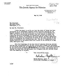
May 15, 1948 Letter From the Agent of the Provisional Government of Israel to the President of the United States,“MY DEAR MR. PRESIDENT: I have the honor to notify you that the state of Israel has been proclaimed as an independent republic within frontiers approved by the General Assembly of the United Nations in its Resolution of November 29, 1947, and that a provisional government has been charged to assume the rights and duties of government for preserving law and order within the boundaries of Israel, for defending the state against external aggression, and for discharging the obligations of Israel to the other nations of the world in accordance with international law. The Act of Independence will become effective at one minute after six o’clock on the evening of 14 May 1948, Washington time.”Also available as PDF from the Truman Library
Question (a): Over which areas of Palestine do you actually exercise control at present over the entire area of the Jewish State as defined in the Resolution of the General Assembly of the 29th November, 1947?
“In addition, the Provisional Government exercises control over the city of Jaffa; Northwestern Galilee, including Acre, Zib, Base, and the Jewish settlements up to the Lebanese frontier; a strip of territory alongside the road from Hilda to Jerusalem; almost all of new Jerusalem; and of the Jewish quarter within the walls of the Old City of Jerusalem. The above areas, outside the territory of the State of Israel, are under the control of the military authorities of the State of Israel, who are strictly adhering to international regulations in this regard. The Southern Negev is uninhabited desert over which no effective authority has ever existed.”Laws and Customs of War on Land (Hague IV); October 18, 1907 Art. 42 SECTION III“Territory is considered occupied when it is actually placed under the authority of the hostile army. The occupation extends only to the territory where such authority has been established and can be exercised. “
On the 31st Aug 1949, Israel made it’s first official claim to territories beyond "the frontiers approved by the General Assembly of the United Nations in its Resolution of November 29, 1947"
AFTER notifying the International Community of Nations/States of the extent of it's Declared Sovereign territories as being "within frontiers approved by the General Assembly of the United Nations in its Resolution of November 29, 1947",
AFTER it had been recognized, according to the notification, by the majority of the International Community of Nations/States (over riding the Arab States legal objections),
AFTER it had confirmed it's military controlled territories outside of the "frontiers approved by the General Assembly of the United Nations in its Resolution of November 29, 1947", i.e., "outside of Israel"
AFTER it had been accepted into the UN, recommended by the UNSC based on the information tendered by the Israeli Government May 22nd 1948 and June 15nd 1949 in respect to the territories it controlled "outside of Israel"
I suggest the lead article be changed to reflect the Israeli Government's statements and the actual legal status of Israel's declared and recognized borders. If it isn’t the “acknowledged” sovereign territory of Lebanon, Syria, Jordan, Egypt or Israel, by default it’s a territory of Palestine…
talknic (talk) 15:14, 1 March 2011 (UTC)[reply]
NMMNG's revert / My restore - The Armistice Agreements and UNSC res 425 are already referenced in the Article[edit]
As it stood before my edit, the Armistice Agreements and UNSC res 425 were already referenced in the Article
Under UNSC Res 425 they were only tasked with defining Lebanese sovereignty, not Israeli borders. The previous edit, which I corrected, was inaccurately portraying the resolution it cited.
The main points of the Armistice Agreements, also already referenced before my edit, surely included the terms of the agreement. Which were "dictated exclusively by military considerations"
Armistice Lines are "Armistice Demarcation Lines", not borders, though they do at some points follow borders which might have existed before the armistice.
This line - "In effect that line was recognised by both Lebanon and by Israel as the international border, and not just as the armistice line of 1949" needs a citation because that ain't what the Armistice Agreement AGREED to and I can not find any WP:RS accurately reflecting the aforementioned claim, so I've contested it.
This line - "On May 25, 2000, Israel notified the Secretary-General that it had redeployed its forces in compliance with Council Resolution 425, that is to the international border" The only mention of an 'international boundary' is the international boundary between Lebanon and Palestine[4]
This Line - "The Blue Line identified by the United Nations in 2000.." was the extent of the sovereignty of Lebanon, according to (the already referenced) UNSC Res 425. Nowhere in the document does it say 'between Lebanon and Israel'[5]
This line - "The armistice line (i.e. Green Line) was the international border, which corresponds to the 1923 Mandate border between the Lebanon and Palestine according to the Armistice Agreement" Article V 1. The Armistice Demarcation Line should follow the international boundary between Lebanon and Palestine.[6]
Same Line - "The armistice line (i.e. Green Line) was the international border, which corresponds to the 1923 Mandate border between the French Mandate of Lebanon and the British Mandate of Palestine (see: Treaty of Sèvres)." A mandate is a set of conditions for administration. Territory has borders, a set of conditions does not. The two territories were Lebanon and Palestine, which were administered by mandates.
You could have challenged the various points in Talk instead of reverting wholesale. If you had reverted every other edit mentioning UNSC Res 425 and the Armistice Agreements you might have had a point. If you reverted other obvious vandalism at the same frequency you revert almost every edit I make, or take other editors to task for introducing Primary Sources into Talk or address edits point by point by other means, it wouldn't appear as though you're on some sort of a weird personal mission ... talknic (talk) 15:04, 24 November 2011 (UTC)[reply]
I don't think this is notable for this article. It doesn't really try to cover the polemical "map war". For example, it doesn't even mention that the Israeli's government's own tourist site has maps not showing the green line [7]. Zerotalk 13:52, 12 April 2012 (UTC)[reply]
Multiple issues with the lede and NOTHING is sourced. The map is very misleading[edit]
NOTHING in the Lede is sourced and there are numerous misleading statements
Israel's borders are the borders of the State of Israel. The borders have changed from time to time with developments in Israel's military and diplomatic situation.
Armistice Demarcation Lines did not change any borders
Israel has never legally annexed any territories it captured in 1948/49 or 1967 Armistice Demarcation Lines and Peace Agreements did not change any borders. The two Peace Agreements "acknowledged" the "recognized" boundaries of Jordan and Egypt, per UNSC res 242. There was no Armistice with Palestine or Peace Agreement with Palestine
The border with Egypt is the international border demarcated in 1906 between Britain and the Ottoman Empire.
Egypt was an Independent Sovereign State before Israel came into existence. Giving Egypt's border is far less confusing. Why cloud the issue?
The borders with Lebanon, Syria and Jordan are based on those drawn up by the United Kingdom and France in anticipation of the defeat of the Ottoman Empire in the First World War and the carve up of the Ottoman Empire between them
Lebanon, Syria and Jordan were Independent Sovereign State before Israel came into existence. Giving their borders is far less confusing. Why cloud the issue?
They are referred to as the 1923 borders, being those of Mandate Palestine, which were settled in 1923
They might be "referred to", but Israel didn't exist in the time of the LoN Mandate for Palestine. There was NEVER a border between Israel and Palestine in the Mandate period
Israel's borders with Egypt and Jordan have now been formally recognised as part of the peace treaties with those countries..
Egypt and Jordanian borders were recognized before Israel came into existence. Under UNSC Res 242 "acknowledgement" of recognized boundaries was required. Both Peace Treaties were executed per UNSC Res 242, which effect only "states"
Lebanon's borders were recognized before Israel came into existence. No borders changed under the Armistice agreement. The Lebanon/Israeli Armistice Line was drawn along the international boundary between Lebanon and "Palestine", not Israel.
Syria's borders were recognized before Israel came into existence. Israel occupies the Golan. Israeli is required, under UNSC res 242 to "acknowledge" "recognized" boundaries and the right to live in peace etc
Israel's borders with the West Bank and Gaza Strip are currently the Green Line, except in East Jerusalem, and the ceasefire line with Syria runs along the UN-monitored boundary between the Golan Heights and Syrian controlled territory.
The Green Line is an Armistice Demarcation Line, Armistice Demarcation Lines specifically did not alter borders. Furthermore the Armistice Agreement was not with Palestine. UNSC res 476 tells us Jerusalem is A) occupied and B) Arab territory
Armistice Agreement Demarcation Lines 1949 Recognized as Israel beginning with the US, May 15th 1948 Allotted to Arab state, occupied by Egypt Feb 1949/Jordan Apr 1949 Allotted to Arab state, occupied by Israel Feb/Apr 1949
The map:
The map should have a 3rd colour showing territories Israel has never legally annexed. There are Armistice Demarcation Lines and lines for the Boundary of the former Palestine Mandate within the colour for Israel. The Armistice Demarcation lines did not delineate or change any borders. The former Mandate lines are largely irrelevant and only serve to cloud the issue (see example right) talknic (talk) 19:19, 27 June 2012 (UTC)[reply]
I see you're picking up right where you dropped off before your "vacation". As you are probably aware at this point, your interpretation of primary sources is not valid material for articles. Find a secondary reliable source that makes the point you have. I see you have also tag bombed the lead with ridiculous reasons. FYI, that is generally frowned upon. No More Mr Nice Guy (talk) 03:02, 28 June 2012 (UTC)[reply]
No More Mr Nice Guy -- A) Please stick to the topic B) I've not suggested any primary sources for inclusion in the article C) Un-sourced material is at odds with editorial policies D) I've tagged far less than the numerous contestable points and brought the matter to talk, per editorial policy E) Personal comments and failing to discuss any of the contested points is in contravention of policy. Please contribute to the article's improvement. Thx
I see. Please provide secondary sources per WP:V that support the changes you'd like to make.
Also, you tagged sentences in the lead that have sources in the body, which is permissible according to WP:LEAD. So perhaps you should start by removing those. No More Mr Nice Guy (talk) 06:42, 28 June 2012 (UTC)[reply]
No More Mr Nice Guy -- A) I've not yet suggested changes, simply pointed to issues. The same issues will arise if they're in the body. B) Quote verbatim which part of "according to WP:LEAD" C) WP:LEADCITE clearly contradicts your claim
I am well aware that Israel has not formally annexed the West Bank (apart from West Jerusalem). I have not read Peter Beinart's book - The Crisis of Zionism. (The link to an article is apparently blocked.) If the review of his book is correct, he agrees with me, or rather, I agree wth him. Israel is trying to have it both ways. Making annexation formal would presumably oblige it to give the Palestinians the right to vote. Arguing what are Israel'd legal boundaries is a pointless exercise. At the extreme are those who say that Israel has no legitimacy at all to those who say that it includes all of Eretz Israel. Trahelliven (talk) 20:39, 29 June 2012 (UTC)[reply]
Trahelliven - "apart from West Jerusalem" On what date did Israel legally annex West Jerusalem in accordance with International Law? talknic (talk) 12:08, 1 July 2012 (UTC)[reply]
Israel's borders are the borders of the State of Israel. - Opening sentence in lede[edit]
Israel's borders are the borders of the State of Israel. This is a tautology and should be deleted. Trahelliven (talk) 20:22, 27 June 2012 (UTC)[reply]
Trahelliven -- It needs something ... suggestions other than deleting? talknic (talk) 17:10, 28 June 2012 (UTC)[reply]
How about: The borders of Israel demarcate the territory of the State of Israel.Tiamuttalk 18:29, 28 June 2012 (UTC)[reply]
Tiamut
The word territory should certainly include all the settlements in the West Bank, in reality the remainder of Area C, probably Area B and possibly Area A. I am in fact surprised that none have in the article directed themselves to whether the West Bank (or parts thereof) and Gaza should be included. The New South Wales Jewish Board of Deputies has taken the bull by the horns and included both - http://www.nswjbd.org/Geography/default.aspx.
I have no other suggestions. As Talknic has pointed out, the whole legality of Israel is wrapped up in attempting to define its borders. It is too complicated for me. I have no suggestions other than to leave the attempt until the Arab-Israeli conflice is ended, one way or another. Trahelliven (talk) 20:54, 28 June 2012 (UTC)[reply]
I fully agree with your comment, but this can be addressed in subsequent sentences that explain that Israel's borders were totally undefined until the peace agreements with Egypt and Jordan delineated the borders with those countries and that they remain partially undefined as regards Lebanon and Palestine. Another sentence can explain that occupied territories belonging to Syria and Palestine have been partially annexed by Israel or are under its military control and that Resolution of the Israeli-Palestinian and Arab-Israeli conflicts will determine Israel's definitive final borders, if any. See this source for a good summary that could be useful to a clearer and more correct intro here. Tiamuttalk 09:27, 29 June 2012 (UTC)[reply]
Tiamut - A) If Israel's borders were totally undefined, how did they as the article now says, "change"?
B) Lebanon, Syria, Egypt and Jordan's borders were recognized BEFORE Israel existed. Israel's borders with those pre-existing states existed by default of those pre-existing recognized borders.
C) Your source does not accurately reflect the documents it cites. The two Peace Treaties were based on UNSC res 242 which called for the "acknowledgement" of "recognized" boundaries. In the peace Treaties, Israel was required to acknowledge those already recognized state boundaries, by withdrawing to them. Armistice Agreements only drew Armistice Demarcation Lines, not borders.
D) The UNSC tells us Israel has not legally annexed any territories.
Statements in Wiki articles must accurately reflect the sources and the sources must accurately reflect the documents they cite to be considered RS talknic (talk) 11:32, 29 June 2012 (UTC)[reply]
Although Israel has not formally annexed any of the West Bank, other than West Jerusalem, the settlements have to be included in Israel's borders. The Jewish inhabitants of the settlements do not live under milirary law. I assume that they use ordinary Israeli postage stamps and currency and vote in Israeli elections etc. The heading of the section perhaps should read just - The West Bank. I would like to add somewhere a simple sentence such as - Whether legal or not, for the time being at least, the Israeli settlements in the West bank should be included in the borders of Israel. Eventually a military occupation must become de facto annexation. Perhaps now, certainly further down the track, the remainder of Area C should be included, and eventually Areas A and B.
(Perhaps the Article should read Borders (de facto) of Israel. This also gets around the problem of states that do not recognise Israel.) Trahelliven (talk) 11:54, 29 June 2012 (UTC)[reply]
The settlements are outside Israel's borders according to Israel's own reckoning. This is nonsense. Zerotalk 12:10, 29 June 2012 (UTC)[reply]
Yes, I fear my comment of support for Trahelliven's position was misplaced. I did not mean to imply that Israeli settlements lie within Israel's borders but only that the some mention should be made of occupied territories in a discussion of Israel's borders.
As for talknic's points:
I'm sorry my comment wasn't clearer and the situation is mighty complicated. But I was referring to Israel's position on its borders, which at the time of its establishment were to leave them purposely undefined, as per this source. Israeli recognition of Egypt and Jordan's borders via the peace agreements with those countries marked a change in that position.
I also agree that the borders of neighbouring countries were defined prior to the emergenceof Israel. That should be mentioned as well.
I further agree that armistice lines are distinctfrom borders and this distinction should be explained as well.
I did not mean to imply that Irael's annexations were legal and of course any mention of themshould also mention that the territories in question are not viewed as part of Israel by the rest of the world.
I was giving a very basic sketch and am happy to work with you and others towards drafting somethingmuch more complete. Tiamuttalk 17:51, 29 June 2012 (UTC)[reply]
Trahelliven -- Can you provide a reliable secondary source giving the date Israel legally annex West Jerusalem according to Customary International Law? (or any territory it has had under military occupation since 1948). de facto is not de jure. The Law tells us whether annexation is recognized is legal or not 2. Affirms that the enactment of the "basic law" by Israel constitutes a violation of international law .
Legal annexation requires either: a referendum between the citizens of the territory to be annexed, sans the citizens of the annexing state. The US was instrumental in this concept being adopted into Customary International Law when a referendum was held of the Mexican citizens of Texas, who agreed 'to be annexed' [to the US]. The US held its own referendum 'to annex' Texas.
Or: An agreement where one side represented by the peoples representative, agrees to cede their territory to another, after which it might be annexed
It's called self determination talknic (talk) 14:42, 29 June 2012 (UTC)[reply]
we could call the article The Borders of the State of Israel, according to Israel. There could then be another article reflecting what the rest of the world thinks.Dalai lama ding dong (talk) 15:24, 29 June 2012 (UTC)[reply]
Dalai lama ding dong -- One would be a minority view :-) talknic (talk) 12:23, 1 July 2012 (UTC)[reply]
Largely refused Israeli citizenship. See [8]: Less than 10 percent of the Golan Druze have chosen to take Israeli citizenship.nableezy - 05:01, 9 May 2013 (UTC)[reply]
The material I removed was (a) polemic - juxtaposing an editorial comment ("However") which does not appear in the source to counter a previous claim, and (b) untrue - the source given does not say it was a recommendation to Britain, but rather to " to the United Kingdom, as the mandatory Power for Palestine, and to all other Members of the United Nations". Primary source material such as the text of 181 should not be used, in any case, and neither one of the sources say "it was not an approval" I invented "it's not you, it's me" (talk) 03:50, 30 December 2014 (UTC)[reply]
New section on international borders was removed, with reason "the only recognition that is relevant is that of the countries on each side of a border, not those on the other side of the world".
There are several other articles, including at least one that concerns the same area, that mention international recognition of the status of territory, as opposed to the recognition of states. Some examples:
- Bir_Tawil: "One exception is Jeremiah Heaton, an American citizen who traveled to Bir Tawil in 2014 to claim the region as a new sovereign state, the Kingdom of North Sudan, and subsequently announced the establishment of self-styled "embassies" elsewhere in the world; no governmental entity has recognized this claim."
Some of the individual articles related to Antarctic land claims also mention recognition, including these ones: Australian Antarctic Territory, British Antarctic Territory, British Overseas Territories, French Southern and Antarctic Lands. Most countries do not have a "Borders of..." article, and most other countries that do seem to have a very short article because those borders aren't disputed. None of the countries that claim parts of Antarctica that I checked seem to have a "Borders of..." article, although every country does seem to have a "Category:Borders of...". The relevant article is International recognition of the State of Palestine, which includes for a list this note: "Some states, marked with an asterisk (*) below, expressly recognised the State of Palestine on the borders of 4 June 1967 [...]" which, notably, are different from the 1948 UN borders. If the news article in the edit under question mentioned under what terms South Africa recognized Palestine, I could add it to that article though it would be much better to add all states that recognize the 1948 borders, but the news article only mentions Israel's borders. 50.135.249.113 (talk) 13:47, 25 April 2015 (UTC)[reply]
There are problems with the creation of a new section on the international recognition of Israel's borders. The main one is that the only relevant recognition is that of the two countries on each side of the border. For example, if Egypt and Israel recognise the 1906 border between them, then it is of no relevance whether France, say, does not. Secondly, the Arab position, reflected in international declarations, is that the borders with Israel should be "based on the 1967 borders". What relevance is there in one distant country still talking of the 1948 borders. And thirdly, the source used is far from being a reliable and unbiased source for the proposition asserted here. Enthusiast (talk) 22:16, 25 April 2015 (UTC)[reply]
It does have practical relevance in that the rights of citizens of countries differ if they do things in territory that the country they're citizens of recognize as the territory of another nation. Legal jurisdiction sort of thing. If it was not important, other articles would not mention international recognition.
The source used is a well-known international news organization, and meets all the criteria for reliability based on Wikipedia's guidelines. If you can identify an alternate reliable source that contradicts the current one, we can conclude that the current one is incorrect. 2601:8:9780:1EE:393C:B840:5370:C2C7 (talk) 07:04, 26 April 2015 (UTC)[reply]
With respect, this is not going anywhere. Perhaps you can start an article on the relevance of third party recognition of borders. It may be related to disputed borders. But here, to pick up on a throw away line in a biased article on a now generally rejected 1948 borders is striving to create a new issue in an already difficult and complex arena. As for the source, you cannot possibly regard the article being used here as a balanced article. With respect again, recognition of a state and the recognition of citizenship may effect how a third party state treats a non-national, but I do not know any source that says that which side of a border a person comes from determines how that third party state will treat that person. It's like saying that a country should treat people differently depending on where they were born and not on what nationality they have at that point of time. Enthusiast (talk) 17:47, 26 April 2015 (UTC)[reply]
How is the article biased? If you can't show why, I will have to add the section back in just on general principles as it would indicate you don't have the best interests of Wikipedia in mind. If aljazeera.com is not a reliable source, then please remove the 15 references to it at Al_Jazeera#References alone. Specific quotes from the article would help to show the information it contains is inaccurate. Well, according to the article Jurisdiction, the legal term for "the geographical area or subject-matter to which such authority applies" is 'competence'. Some relevant stories: someone who abducts children for a living; a school found to be abusive that wasn't closed because it was on overseas territory. It's not about where someone was in the past; it's about where they are in the present, and what governments can do to them, or for them, as a result. Like that US Marine who was arrested at the border between Mexico and the US, and held for 7 months in jail. In that case, it was fully within the rights of the Mexican government to do that because he had crossed into Mexican territory.
Also, if you just repeat another variation on "the article is biased" without explaining why, then I will assume you can't explain why and restore the section, and if you revert it I'll have you blocked from editing this article or whatever. 50.135.249.113 (talk) 17:48, 25 May 2015 (UTC)[reply]
I have just modified 3 external links on Borders of Israel. Please take a moment to review my edit. If you have any questions, or need the bot to ignore the links, or the page altogether, please visit this simple FaQ for additional information. I made the following changes:
When you have finished reviewing my changes, please set the checked parameter below to true or failed to let others know (documentation at {{Sourcecheck}}).
This message was posted before February 2018. After February 2018, "External links modified" talk page sections are no longer generated or monitored by InternetArchiveBot. No special action is required regarding these talk page notices, other than regular verification using the archive tool instructions below. Editors have permission to delete these "External links modified" talk page sections if they want to de-clutter talk pages, but see the RfC before doing mass systematic removals. This message is updated dynamically through the template {{source check}} (last update: 18 January 2022).
If you have discovered URLs which were erroneously considered dead by the bot, you can report them with this tool.
If you found an error with any archives or the URLs themselves, you can fix them with this tool.
I have just modified 3 external links on Borders of Israel. Please take a moment to review my edit. If you have any questions, or need the bot to ignore the links, or the page altogether, please visit this simple FaQ for additional information. I made the following changes:
When you have finished reviewing my changes, you may follow the instructions on the template below to fix any issues with the URLs.
This message was posted before February 2018. After February 2018, "External links modified" talk page sections are no longer generated or monitored by InternetArchiveBot. No special action is required regarding these talk page notices, other than regular verification using the archive tool instructions below. Editors have permission to delete these "External links modified" talk page sections if they want to de-clutter talk pages, but see the RfC before doing mass systematic removals. This message is updated dynamically through the template {{source check}} (last update: 18 January 2022).
If you have discovered URLs which were erroneously considered dead by the bot, you can report them with this tool.
If you found an error with any archives or the URLs themselves, you can fix them with this tool.
I have just modified 5 external links on Borders of Israel. Please take a moment to review my edit. If you have any questions, or need the bot to ignore the links, or the page altogether, please visit this simple FaQ for additional information. I made the following changes:
When you have finished reviewing my changes, you may follow the instructions on the template below to fix any issues with the URLs.
This message was posted before February 2018. After February 2018, "External links modified" talk page sections are no longer generated or monitored by InternetArchiveBot. No special action is required regarding these talk page notices, other than regular verification using the archive tool instructions below. Editors have permission to delete these "External links modified" talk page sections if they want to de-clutter talk pages, but see the RfC before doing mass systematic removals. This message is updated dynamically through the template {{source check}} (last update: 18 January 2022).
If you have discovered URLs which were erroneously considered dead by the bot, you can report them with this tool.
If you found an error with any archives or the URLs themselves, you can fix them with this tool.
Extended-confirmed-protected edit request on 1 September 2017[edit]
This edit request has been answered. Set the |answered= or |ans= parameter to no to reactivate your request.
In this section, the caption of Israel's green lines map is wrong. It should say the other way around: demilitarized zones (in border with Syrian Golan and "No man's land" near Latrun) are marked by dark green, while Green Line in general is in light green. Can you see the mistake in description?--181.93.81.159 (talk) 03:53, 1 September 2017 (UTC)[reply]
Note: I will not answer this edit request as this same IP went to my Talk page to look at this edit request. OP, the point about an edit request is to make the request and leave it for an editor to review without reminding them on their Talk page. Please understand that not all editors are available. jd22292(Jalen D. Folf) (talk) 04:05, 1 September 2017 (UTC)[reply]
I clarified this. I believe the line is actually dark green in the image (possibly more than the shaded area) - it just "appears" lighter since it is thin and next to white (particularly when resized and interlopated). Instead of specifying color - I specified "green thin line" and "green thick line/areas).Icewhiz (talk) 06:21, 1 September 2017 (UTC)[reply]
Extended-confirmed-protected edit request on 12 December 2017[edit]
This edit request has been answered. Set the |answered= or |ans= parameter to no to reactivate your request.
Thanks for your reply. The old link works because it is redirected. This old link should be replaced with the new one noted above. Genewiki1 (talk) 23:13, 12 December 2017 (UTC)[reply]
"On 15 May 1948, the Transjordanian Arab Legion, in conjunction with other regular Arab armies, entered what had been Mandate Palestine, seizing control of what come to be called the West Bank, East Jerusalem including the Old City. The tide of battle soon turned against the Arabs, and Israel then launched a series of military offensives, greatly expanding its territorial holdings." --- I don't have time lately, but I recall that much of these expanded territories were already held before May 15. So I challenge the implication that the expansion was a reaction to the Arab armies. Zerotalk 21:56, 9 February 2020 (UTC)[reply]
You are correct - the map above illustrates it (although I cannot vouch for the accuracy/sourcing of the map). Onceinawhile (talk) 00:08, 10 February 2020 (UTC)[reply]
Perhaps it would be better if this already quite long article was split up in such a way?
The current article is also ipso facto Israel-centric (possible neutrality issues) ... splitting it would give the bordering countries equal weight.
WisDom-UK (talk) 21:26, 31 March 2020 (UTC)[reply]
I forgot to add the split tag so have done so now.WisDom-UK (talk) 14:21, 1 September 2020 (UTC)[reply]
OK as far as I am concerned. Onceinawhile (talk) 16:30, 1 September 2020 (UTC)[reply]
Maybe. The scope should be discussed. I think such articles should contain the history of the boundary including the Ottoman and Mandate periods. What concerns me the most is that the articles might degenerate into yet another dreary recitation of border incidents. Zerotalk 04:14, 2 September 2020 (UTC)[reply]
Per Zero. Of course, there is no "Israel" pre 48 to have borders of, only Zionist pretensions to. I would suggest to maybe get this history aspect into the current article before splitting it?Selfstudier (talk) 10:03, 2 September 2020 (UTC)[reply]
Yes, I was thinking just using the template that is on other pages e.g. Jordan–Syria border, Syria–Turkey border, Iraq–Saudi Arabia border etc. Basically covering: Description of the border, History of the border, Border crossings. The History section would over the creation of the boundaries in the Palestine mandate period.WisDom-UK (talk) 11:14, 2 September 2020 (UTC)[reply]
Support - the article is just 54k, but indeed all other borders are "X-Y border" type articles.GreyShark (dibra) 13:48, 4 October 2020 (UTC)[reply]
Coolio, I am going to this soon, I got distracted working on other pages. I'm not sure whether it's worth keeping a 'shell page' for 'Borders of Israel'. IMO they are generally poor quality, and where 'Border x-y' articles exists they are redundant, though when I nominated some of these for deletion (Russia, Azerbaijan, China etc.) the consensus was to keep them.WisDom-UK (talk) 15:37, 4 October 2020 (UTC)[reply]
Edit request: add key on the map for colors?[edit]
It's not clear what exactly yellow and green represent on the title map. Can we clarify in the caption or the actual PNG what green and yellow precisely mean? Quohx (talk) 05:42, 21 March 2022 (UTC)[reply]
Israel has never officially declared its borders, not in its declaration of independance, nor later. I think that is a very important issue to mention. One can read about it here. https://m.jpost.com/israel-news/article-709240Besserwisser32 (talk) 15:01, 13 August 2023 (UTC)[reply]
Interesting, I hadnt seen this letter before. I do know that Israel's application to the UN was rejected by the security council for reasons which include that it hadn't declared its borders[1]DMH43 (talk) 22:30, 9 January 2024 (UTC)[reply]


 Note: I will not answer this edit request as this same IP went to my Talk page to look at this edit request. OP, the point about an edit request is to make the request and leave it for an editor to review without reminding them on their Talk page. Please understand that not all editors are available. jd22292 (Jalen D. Folf) (talk) 04:05, 1 September 2017 (UTC)

 Quohx (talk) 05:42, 21 March 2022 (UTC)
