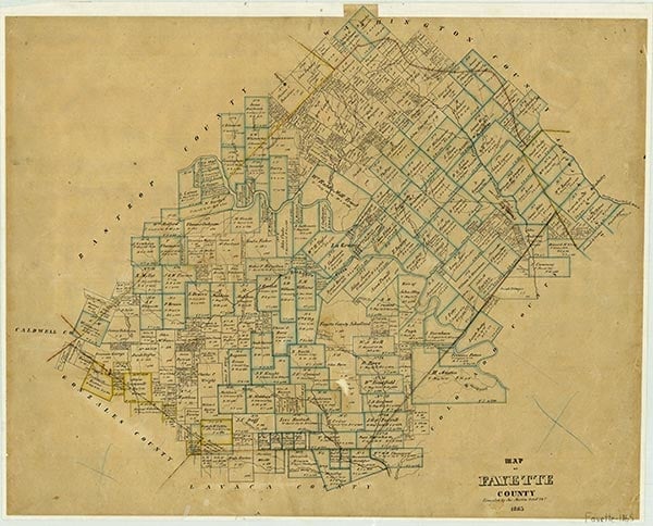
Fayette County is on Interstate Highway 10 sixty miles southeast of Austin in the Blackland Prairies region of south central Texas. The center of the county lies at 29°55' north latitude and 96°55' west longitude. La Grange is the county seat and largest community. In addition to Interstate 10, transportation needs are served by U.S. highways 77, 90, and 290 and State highways 71, 95, 159, and 237. The county's terrain varies from level land to steep slopes, with altitude ranging from 200 to 600 feet. The Colorado River, which bisects the county from northwest to southeast, is fed by several major creeks: Rabb's, Cedar, and Baylor on the east and Buckner's and Williams on the west. Cummins Creek flows through the eastern part of the county and the East and West Navidad rivers through the southern part. Potable groundwater is readily available from the Carrizo-Wilcox and Catahoula-Oakville aquifers at relatively shallow depths. The county covers 950 square miles and is composed of three land resource areas—Blackland Prairies (63 percent), the Post Oak Belt (30 percent), and the Colorado river bottom (7 percent). Within the Blackland Prairie on the uplands are the clayey blacklands and loamy claypen areas. The bottomlands contain dark loamy and clayey soils. The Post Oak Belt contains the Texas Claypan Area with uplands of gray, slightly acid sandy loam and sandy to clayey bottomland soils. Scattered outcrops of the Willis Formation form gravelly ridges along the Colorado River and large areas of gravelly soils in the northern half of the county. The vegetation is a mixture of the post oak savannah and Blackland Prairie region, with tall grasses, oak, and elms predominating. Also commonly found are eastern red cedars, pecans, cottonwoods, and sycamores. Some hickory, walnut, mesquite, and yaupon grow in diverse areas. The north central section is forested by loblolly pine, a continuation of the Lost Pines Forest of neighboring Bastrop County. Whitetail deer are native to the area, especially in the timbered areas, and raccoon, beaver, and possum live along the many creeks. Coyotes are so numerous that a control program has been instigated. Game species found in this district include squirrel, quail, dove, and water fowl. Southern bald eagles traverse the county, particularly along the Colorado River. Natural resources include timber, lignite, sand, gravel, bleaching clays, volcanic ash, oil, and gas. The climate is subtropical humid, with hot summers and mild winters. The average annual precipitation is thirty-six inches. Temperatures range from an average low of 41° F in January to an average high of 96° in July, and the average growing season is 277 days. Flooding is common along the Colorado River; major floods in 1869, 1870, 1900, 1938, and 1992 caused considerable damage to crops and property.
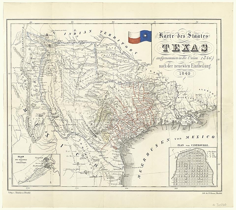
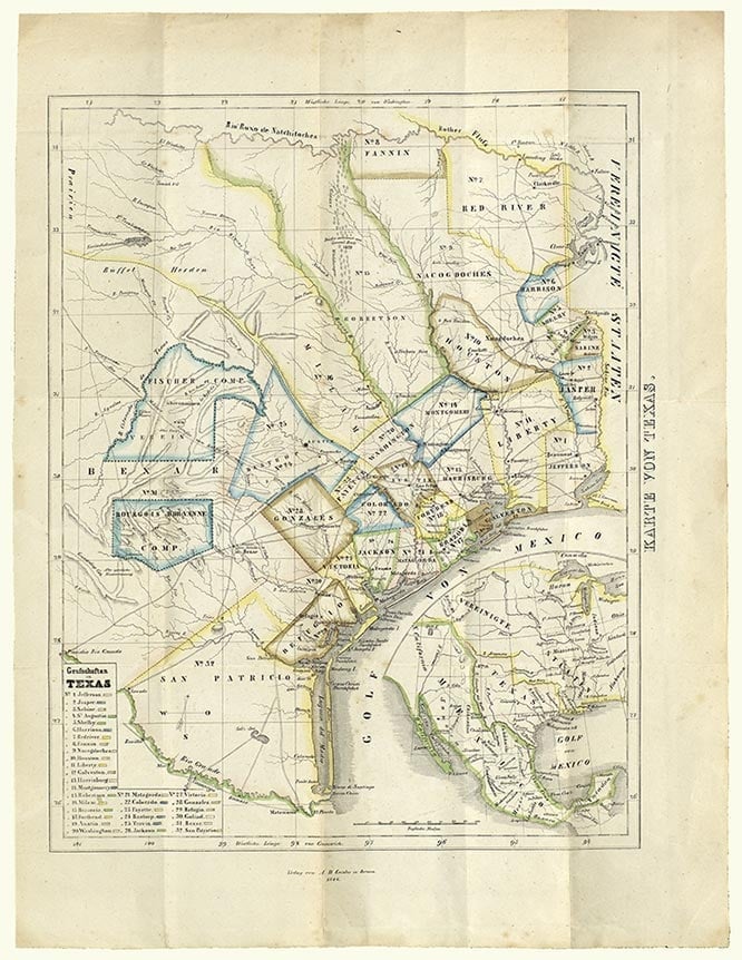
Prior to European settlement Lipan Apaches and Tonkawa Indians inhabited parts of what is now Fayette County. Many Indian artifacts have been found, especially along the Colorado River and near Round Top. A few miles north of the Colorado River, above Little Pin Oak Creek, a stratified multicomponent campsite was found, with Clovis, Plainview, and other later artifacts. In the early eighteenth century Spanish explorers passed through the area. La Bahía Road, which ran southwest to northeast and crossed the river at the site of present La Grange, was the major route for travel during the Mexican period. The area was part of Stephen F. Austin's first colony, but the earliest known White settlers, Aylett C. Buckner and Peter Powell, arrived earlier and lived on La Bahía Road west of La Grange, where they ran a trading post. Formal settlement began in 1822 with the arrival of the Austin colonists. From 1824 to 1828 ten members of the Old Three Hundred received title to their land grants in the fertile Colorado River valley; William Rabb received four leagues in order to build a mill. A total of ninety-two Mexican land grants were granted in the area that is now Fayette County. The earliest settlers gathered at Wood's Fort, Moore's Fort (La Grange), the James Ross home, and Jesse Burnam's blockhouse, twelve miles below La Grange. Burnam's Ferry on the Colorado River provided a cutoff route from La Bahía Road to San Felipe. Prior to Texas independence, the area above La Bahía Road was in the Mina Municipality and the area below in the Municipality of Colorado. Gotier's Trace, the Wilbarger Trace, and the La Grange-San Felipe road intersected La Bahía Road. Ferries were used to cross the Colorado River until the first bridge was built at La Grange by private subscription in 1883. On December 14, 1837, upon petition of the citizens, the Congress of the Republic of Texas established the county of Fayette, named in honor of the Marquis de Lafayette. La Grange, the name of the chateau to which Lafayette retired, was designated the county seat. The citizens organized the county government on January 18, 1838, and the southwestern boundary of the county was extended westward on May 3, 1838. The county lost territory in the south to Lavaca County in 1854 and in the north to Lee County in 1874.
The early settlers' life revolved around their plantations, but problems with Indians occupied much of their time. Sometimes the settlers felt so threatened that they moved down to the lower Colorado River area. At other times they grouped together, sometimes aided by Lipan Apache and Tonkawa Indians who were friendly to the settlers, to resist marauding bands of Comanches, Wacos, and Kichais. Fayette County men were prominent in the Texas Revolution; more than fifty men participated in the battle of San Jacinto, including Joel W. Robison, one of the captors of Antonio López de Santa Anna. The Somervell, Mier, and Dawson expeditions were composed mostly of Fayette County men. In 1848 the remains of the men killed in the Dawson Massacre and in Perote Prison were returned to Fayette County and interred on Monument Hill; in 1933 a granite tomb was dedicated there (seeMONUMENT HILL-KREISCHE BREWERY STATE HISTORIC SITE). The historic Muster Oak, still standing on the square, has been a rallying site since the early settlement. William Menefee, a signer of the Texas Declaration of Independence, was from Fayette County. A proposal to permanently locate the state capital in Fayette County was approved on April 11, 1838, by an overwhelming majority of the Second Congress. Local citizens arranged for the purchase of the Eblin league on the east side of the Colorado River near La Grange, reserving all vacant lands within a nine-mile radius. The measure was vetoed by Sam Houston, however, and the capital was located upriver in what later became Austin.
The first private schools opened in the county as early as 1834. Academies and institutes were operated in La Grange, Fayetteville, and Round Top in the 1840s. The Methodists founded Rutersville College, one of the first colleges in Texas, in 1840; it consolidated with the Texas Military Institute, Galveston, in 1856. The earliest churches organized in the county were Methodist (1838), Baptist (1839), Presbyterian (1841), and Episcopal (1852). Most of the early settlers were from the Old South, but the Austin Colony also included a few German immigrants. In 1832 Joseph Biegel received title to a league in the area and developed the first German community in the county, Biegel Settlement. In the 1840s many more German immigrants settled in Fayette County. The Adelsverein purchased a league in 1843 and established a plantation called Nassau Farm. During the mid-1850s sizable numbers of Bohemian Czechs also began moving into the county. In the 1856 the first Bohemian settlement in Texas, Dubina, was founded in Fayette County. The county's population grew rapidly, especially after Texas joined the Union; already by 1850 it had 3,756 residents. During the early years the economy was based largely on subsistence farming, but during the late 1840s and 1850s a thriving plantation economy emerged. In the early 1850s plantations were producing impressive quantities of corn and shipping tobacco, wool, and cotton to outside markets. To clear land, harvest crops, and perform other forms of labor, planters brought in increasing numbers of African-American slaves. Between 1840 and 1850 the slave population grew from 206 to 820, and by 1855 the number had reached 2,072. On the eve of the Civil War Fayette County was among the most well-developed areas in the state, with nearly 1,000 farms containing 75,463 improved acres. In 1859 farmers produced 12,683 bales of cotton and 320,580 bushels of corn, placing Fayette County among the state's leaders in both categories. The population of 11,604 was more than three times what it had been only a decade before; the number of slaves alone (3,786) in 1860 exceeded the entire population for 1850. Despite the county's large slave population, however, voters narrowly rejected secession by a margin of forty-six votes (626 against, 528 for), primarily due to the area's numerous German and Bohemian residents, who generally opposed slavery. Despite the result, after the war broke out three volunteer companies were immediately organized, and before the war's end a total of about 800 men had served in the Confederate army.
The Civil War and its aftermath brought profound changes to the county. Although it made only a small material contribution to the war effort, the lack of markets and wild fluctuations in Confederate currency caused hardships for many. The end of the war brought wrenching changes in the economy. For many Whites the abolition of slavery meant devastating economic loss. Before the war slaves had constituted more than a third of all taxable property in the county, and their loss coupled with a sharp decline in property values caused a profound disruption for most planters. The county's African Americans fared no better. Although most of the county's Black residents remained, many left the farms owned by their former masters to seek better working conditions. For the vast majority, the change brought only marginal improvement in their living and working conditions; most ended up working on the land on shares, receiving one-third or one-half of the crop for their labors.
During Reconstruction Fayette County received little attention from federal political or military authorities. Federal troops were stationed there only briefly, and there was little of the violence that many other areas experienced. The economy began to recover in the late 1860s, and by 1870 production levels neared or exceeded the 1860 figures. During the next three decades the county experienced a long period of growth, fueled in large measure by a surge of new German and Slavic residents. Many of the early plantation owners, hard-pressed to make ends meet without their slaves, sold their lands to German, Bohemian, or Wendish settlers, who in turn sold portions of it to others. As a result the large plantations that had dominated antebellum Texas were gradually replaced by smaller, more numerous farms. This trend is reflected in the agricultural census of the late nineteenth century, which shows the number of farms increasing from 1,483 in 1870 to 5,189 in 1900. The number of acres under cultivation also grew dramatically during this period, rising from 76,401 to 287,853. Although the new farms were smaller, they tended to be much more productive because of intensive cultivation by the Germans and Bohemians. Most of these small farmers grew cabbages, tomatoes, potatoes, beans, peas, turnips, and peaches, but the leading cash crops remained cotton and corn. In 1880 farmers produced 24,766 bales of cotton and 694,833 bushels of corn; by 1890 cotton output had grown to 37,559 bales, and corn production topped 912,000 bushels.
The influx of Germans, Czechs, and Wends after the Civil War also gradually altered the cultural face of the county. Although some of the new settlers moved in from other counties, including most of the Wends, many of the settlers were new immigrants who brought their own distinct culture with them. The tide of immigration was particularly strong in the 1880s, as numerous additional German and Bohemian settlers arrived. By 1890 nearly one-fourth of the county's residents (7,856 of 31,481) were foreign-born, with the largest contingents from Germany (3,667) and Austria-Hungary (3,224). As a result, by the late nineteenth century many of the leading businesses and civic organizations were dominated by Germans and Czechs. During the late nineteenth and early twentieth centuries La Grange had two foreign-language newspapers, the Svoboda (Czech) and the La Grange Zeitung (German). The Germans and Czechs formed shooting clubs, poetry groups, and fraternal and religious organizations. The KJT (Czech Catholic Union), the SPJST (a Czech benevolent society), and the Round Top Rifle Association, founded in the nineteenth century, still existed in the early 1990s. Public education in the late nineteenth and early twentieth century was supplemented by private and parochial schools, which were often taught in German and Czech. Despite the increasing number of White residents, African Americans continued to form a large segment of the population. In 1870 the Black population was 5,901, and as late as 1900 Blacks still represented about one-third of the population; in spite of these numbers, however, African Americans had little political power. While Fayette County citizens rejected the white primary—largely due to German and populist sentiment against it—African-American voters were often excluded from voting and had little say in the local political structure.
During the early decades of the twentieth century Fayette County continued to grow and prosper. Corn remained an important crop, with cattle and dairy products also providing significant sources of income. But it was cotton which emerged as the single largest cash crop. Cotton production averaged more than 30,000 bales annually between 1900 and 1930, and by 1929 more than half of all of the cropland (118,256 of 196,847 acres) was devoted to cotton. The growth of cotton in turn fueled a steady rise in farm tenancy. By 1920 nearly half of all farmers (2,195 of 4,728) were tenants. During the years of the Great Depression, when nearly all farmers suffered, these tenants found themselves particularly hard pressed. Overproduction, droughts, and boll weevil infestations combined to drive down prices and reduce the crop size. Between 1930 and 1940 the amount of land planted in cotton fell by more than 50 percent (from 118,858 to 50,858 acres), and production was barely a third of what had been during the peak years of the 1920s. After World War II the agricultural emphasis changed. Cotton continued to be grown on a much smaller scale through the early 1950s, but farmers also turned increasingly to cattle raising. By 1987 there were 2,235 milk cows and 110,511 head of cattle in the county, and cotton was no longer being grown. Due to rich soils and abundant surface and ground water, Fayette County remains an important agricultural county. In the late 1980s it ranked among the top three counties in the state in cow and calf production. In 1989 there were 2,476 producers. Leading crops included corn, grain sorghums, peanuts, and pecans. The estimated gross agricultural income for 1988 was $42,427,000—beef cattle 57 percent, grain 10 percent, poultry (eggs) 8 percent, swine 8 percent, hay 8 percent, dairy products 7 percent, pecans 1 percent, and miscellaneous 1 percent. Of the 2,750 farm operators, about half held additional jobs.
During the 1980s and 1990s the economic development of the county was largely dependent on its natural resources. Construction gravel and sand, grinding pebbles, clays, and fuller's earth were mined. Oil, first discovered in 1943, was an important source of income. Due to new horizontal drilling techniques Fayette County experienced a dramatic rise in oil and gas production in the early 1990s. As a highly active part of the Giddings oilfield of the Austin Chalk trend, the county produced 14,044,733 barrels of oil and 72,469,984 million cubic feet of gas in 1992. Timber is selectively cut for commercial purposes from 28,200 acres of privately owned woodlands. Agribusiness plays a major role in the economy. Light industry includes shops, a cabinet factory, plastic recycling, gas processing, and other manufacturing. The Lower Colorado River Authority Fayette Power Project is the largest employer in the county, with around 500 workers. Other sources of employment are banking, services, retail sales, trucking, government, schools, and drilling and pipeline management.
Beginning in 1872, the development of the railroad system caused the decline of many rural communities and the development of the new towns of Schulenburg and Flatonia. In the 1990s three railroad lines crossed the county—the Missouri, Kansas and Texas from east to west and two branches of the Southern Pacific, one from north to south and the other along the southern boundary. By the early twenty-first century, all of these lines were being operated by the Union Pacific Railroad. A public airport for light planes was located in La Grange. Fayette County has published English-language newspapers since 1843. Three were published in the early 1990s—the Fayette County Record, the Flatonia Argus, and the Schulenburg Sticker. In the early 1990s there were five independent school districts, one Catholic high school, and two Catholic schools through eighth grade. Although Father Michael Muldoon visited the county under Mexican rule, followed by other visiting priests and Lutheran pastors, the Catholic and Lutheran churches did not flourish until the second half of the nineteenth century under German, Czech, and Wendish influence. On December 25, 1872, Fr. Josef Chromcik arrived at Fayetteville. He was the first Czech priest to serve the county's Moravian and Czech Catholics. In the 1990s there were sixty churches and one Jewish temple; Lutheran and Catholic churches accounted for half the total.
For much of the county’s history, its voters were Democratic or independent, and Democratic candidates have typically received the majority of the county's votes into the mid-twentieth century. Populist, Greenback, and other third-party candidates fared well during the late nineteenth and early twentieth centuries. In the late 20th century, however, Republicans have been making strong inroads, particularly in presidential and statewide races. Republican presidential candidates won a majority of the county’s voters in every election between 1968 and 2004, with the exception of 1976, when Democrat Jimmy Carter eked out a narrow victory. Democratic officials continued to maintain control of most county offices into the late 20th century, and as late as 1982, 97 percent of voters in the primary voted Democratic. By 2004, however, about half of the county’s voters participated in the Republican primary, and Republican candidates were competitive even at the local level.
The population of Fayette County reached an all-time high of 36,542 in 1900 but has been gradually declining. The population was 29,796 in 1910, 29,965 in 1920, 30,708 in 1930, 29,246 in 1940, 24,176 in 1950, 20,384 in 1960, 17,650 in 1970, and 18,832 in 1980. In 1990 the county recorded a small gain, rising to 20,095. The largest communities were La Grange (3,951), Schulenberg (2,455), Flatonia (1,291), and Fayetteville (283). The largest minority groups were African Americans (8.4 percent) and Hispanics (8.5 percent). Most of the residents (80 percent) live in small communities or rural areas. Tourism and recreation were becoming a growing economic resource for Fayette County. The cooling pond of the Fayette Power Project hadbeen developed into a stocked fishing lake of 2,400 surface acres, averaging a depth of thirty feet. It wasopen to the public and had become especially popular with bass fishermen.
In 2014 the U.S. Census counted 24,833 people living in Fayette County; about 72.7 percent were Anglo, 19.6 percent Hispanic, and 6.8 percent African-American. Of residents twenty-five and older, about 62 percent had graduated from high school, and almost 15 percent had college degrees. In the early twenty-first century agriculture, the production of minerals and electricity, small manufacturing concerns, and tourism are important elements of the local economy. In 2002 the county had 2,973 farms and ranches covering 552,414 acres, 44 percent of which were devoted to pasture and 40 percent to crops. That year farmers and ranchers in the area earned $51,696,000; livestock sales accounted for $46,438,000 of the total. Beef cattle, corn, sorghum, hay, and peanuts were the chief agricultural products. La Grange (population, 4,622) is the county’s seat of government and largest town; other communities include Schulenberg (2,860), Flatonia (1,365), Fayetteville (255), Round Top (88), and Winedale (232). Monument Hill-Kreische Brewery State Historic Site, the historic Henkel Square in Round Top, and Winedale Historical Center draw visitors year round. Antique fairs, the International Festival-Institute at Round Top, ethnic and town festivals, and the County Fair are popular special events. The "painted churches" at Dubina, Praha, Ammansville, and High Hill offer popular historic-preservation tours, and each of the four major towns has a museum actively preserving county history.
Is history important to you?
We need your support because we are a non-profit that relies upon contributions from our community in order to record and preserve the history of our state. Every dollar helps.
Frank Lotto, Fayette County: Her History and Her People (Schulenburg, Texas: Sticker Steam Press, 1902; rpt., Austin: University of Texas Press, 1981). Worth Stickley Ray, Austin Colony Pioneers (Austin: Jenkins, 1949; 2d ed., Austin: Pemberton, 1970). Julia Lee Sinks, Chronicles of Fayette (La Grange, Texas, Bicentennial Commission, 1975). Julia Lee Sinks, "Editors and Newspapers of Fayette County," Quarterly of the Texas State Historical Association 1 (July 1897). Houston Wade, comp., The Dawson Men of Fayette County (Houston, 1932). Leonie Rummel Weyand and Houston Wade, An Early History of Fayette County (La Grange, Texas: La Grange Journal, 1936).
The following, adapted from the Chicago Manual of Style, 15th edition, is the preferred citation for this entry.
Daphne Dalton Garrett,
“Fayette County,”
Handbook of Texas Online,
accessed April 26, 2024,
https://www.tshaonline.org/handbook/entries/fayette-county.
Published by the Texas State Historical Association.
TID:
HCF03
All copyrighted materials included within the Handbook of Texas Online are in accordance with Title 17 U.S.C. Section 107 related to Copyright and “Fair Use” for Non-Profit educational institutions, which permits the Texas State Historical Association (TSHA), to utilize copyrighted materials to further scholarship, education, and inform the public. The TSHA makes every effort to conform to the principles of fair use and to comply with copyright law.
If you wish to use copyrighted material from this site for purposes of your own that go beyond fair use, you must obtain permission from the copyright owner.