Outdated FEMA flood maps leave Broome County residents in limbo

News


C arol Grippen remembers watching the water creep toward her house as she backed away in her year-old black Hyundai Elantra.

She recalls the smell, a combination of mold and rotten fish, that lingered in her nostrils for weeks after floodwaters seeped into her two-story house on Laurel Avenue in Binghamton.

She remembers thumbing through waterlogged mementos from her 34 years as a first-grade teacher ― class pictures, student projects, letters from parents ― and her reluctance to discard them.

When Grippen, 73, saw the devastation caused by recent hurricanes, the memories came rushing back, just like the water had into her home that warm Wednesday in September 2011.

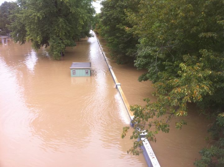
And in 2006. And 2005. The flooding of 2011 was the third time in seven years that water from the Susquehanna River rose above the city’s levees, crawled toward her home and ensured a long recovery.

Time Lapse

Last month marked six years since southern Broome County was inundated by the worst flooding to date. Since the remnants of Tropical Storm Lee caused 24,000 people to evacuate and levied $502.8 million in property damage. Since Gov. Andrew Cuomo helicoptered over the rust-colored floodwaters, declaring a state of emergency that lasted over a week.

It’s been more than 30 years since the Federal Emergency Management Agency (FEMA) flood maps for Broome County have been updated.

Pipe Dream Archives Emergency workers enter MacArthur Elementary School on Vestal Avenue in Binghamton on Wednesday, Sept. 7, 2011.

New Maps = A Safer Public

“New Maps = A Safer Public.” That was the message printed in bold type on flyers distributed to Broome County residents in April 2010. FEMA and the New York State Department of Environmental Conservation held four public open houses outlining the county’s new flood maps, encouraging residents to become familiar with them before their adoption.

“By showing the extent to which areas are at risk for flooding, the new flood maps will help home and business owners understand their current risk and make informed decisions about protecting their property,” the flyer read.

After the flood of 2006, FEMA began to redraw the maps, which determine hazard levels for properties based on location. The primary area of concern is the special flood hazard area, where properties are at a 1 percent annual flood risk and homeowners are required to purchase flood insurance if their mortgages are federally backed.

The new maps identified 12 sections of Broome County’s levee system that failed to meet FEMA flood-protection requirements. The city of Binghamton, villages of Endicott and Johnson City and towns of Vestal and Union were most widely affected by the finding. Broome County’s original maps include 1,955 properties within the special flood hazard area. That figure nearly tripled to 5,606 under the preliminary maps released in 2010.


Scrap the maps

Shortly after the maps first went public, Sen. Chuck Schumer and former Rep. Maurice Hinchey (D-NY) penned a letter to former FEMA Director Craig Fugate, asking for them to be put on hold. They were, and the following year, the remnants of Tropical Storm Lee threw southern Broome County into another state of emergency.

Schumer and Hinchey, along with local officials and their constituents, took issue with the binary way that flood risk and insurance premiums had been determined.

“In the old process, called the no-levee approach, they said, ‘We’re going to imagine there is no levee whatsoever,’” said Frank Evangelisti, Broome County director of planning.

The shelving of the maps was surprising, Evangelisti said, because they’d been so close to effective status.

“It was a very unusual circumstance because we do have a lot of levees and floodwalls in Broome County — it’s a big part of our landscape,” he said.

The pushback was part of a national trend of communities that believed the flood-risk maps were unnecessarily strict and put an unfair burden on homeowners.

“Communities across the country were concerned that the process of drawing the flood maps in those areas was not accurate,” Evangelisti said. “FEMA then took a step back and withdrew flood maps nationwide. Anybody that was in the process of getting new flood maps across the country got put on hold.”

Following Hurricane Sandy in 2012, FEMA redrew the maps for New York City, almost doubling the number of properties in the highest-risk zone. The city disputed these findings, hiring a consulting firm that came up with a narrower zone.

The typical time frame for a map to go from starting point to effective is around five years, according to J. Andrew Martin, chief of FEMA’s Region II risk analysis branch. Broome County’s have been in the works for twice as long.

“I feel like we are not providing a good level of customer service to property owners in Broome County by not providing this information in a way that they can make decisions based on it,” Martin said in a recent interview.

‘I thought it’d never happen again’

The terms often used to describe majors floods ― “100-year flood” and “500-year flood” ― can be misleading. Many homeowners believe 100-year floods will happen just once a century. That’s just not right, according to those well-versed in flood risk, and leads to risk not being taken as seriously as it should.

“In 2006, everyone kept saying, ‘Oh my god, this is a 500-year flood; you’ll never get flooded again,” Grippen said. “I thought it’d never happen again in my lifetime.”

Federal and local officials have stopped using these terms, instead referring to severe flooding events as 1 percent annual-chance floods.

“That means in any given year, there’s a one in 100 chance there will be a flood,” Martin said. “And a 500-year flood means that in any given year, there’s a one in 500 chance there will be a flood.”

Over the course of a 30-year mortgage, there’s a 26 percent chance of a flood occurring, compared to a 5 percent chance of fire. But that fact hasn’t translated to a widespread demand for flood insurance.

“If I told the average New Yorker there’s a one in 100 chance that they’d win the Powerball, they’d be going in droves to buy tickets,” said Jim Rollo, a State Farm insurance agent in the Binghamton area who sells flood insurance.


Orla McCaffrey/News Editor The confluence of the Susquehanna and Chenango rivers in Downtown Binghamton.

Insurance Insecurity

Grippen had purchased flood insurance in the past, but let it lapse when nothing happened. After all, her home wasn’t mapped into the flood zone.

“Four houses from the river and I wasn’t in the flood zone,” she said.

In June 2006, an early summer storm pounded the area, causing heavy rainfall and flash flooding for three days. When the clouds parted, two feet of water stagnated on the first floor of Grippen’s home.

“Everything on the first floor got destroyed — it was a real mess,” she said. “We were out of the house until the fall.”

A $71,000 loan, which took 10 years to pay off, helped finance the remodel.

“[FEMA] gives you a nice loan and says, ‘Here, go fix your house,’ and you’re like, ‘OK,’ because what are you going to do, you know?” she said. “You have to fix the house.”

Under the preliminary FEMA map update, Grippen’s house would have been within the special flood hazard area, so she would’ve been forced to buy insurance.

Insurance rates can range between $1,800 and $2,400 for one year, according to Rollo.

“Everybody should have flood insurance, regardless of whether you’re mapped inside the special flood hazard area or not,” Martin said.

But for some Broome County residents, that extra cost could mean not being able to afford their monthly mortgage payments. The median household income in the county is $46,261, well under the New York state median of $60,850. The poverty rate is 17.7 percent, higher than the national average of 14.7 percent, according to the U.S. Census Bureau.

More than 7,000 properties are at least partially mapped into the special hazard flood area according to the preliminary map, but there were just 1,433 flood insurance policies in effect in the county as of July 2017.

“I could take you to places that were totally underwater, but very few people have flood insurance,” Rollo said. “Even places that flooded are not currently mapped into a flood zone because the maps haven’t changed.

After Grippen fixed her home, descending into the basement daily to spray Clorox on neon-green mold, she knew what she had to do next: get insurance.

She called Servpro, a Southern Tier restoration company and paid less than $1,000 for her policy.

“I could take you to places that were totally underwater, but very few people have flood insurance.”

On that Wednesday five years later, the rain started after dawn. Grippen kept getting up to look out the window.

“Marcia, the river is really coming kind of high,” she kept saying to her daughter.

A few hours later, a neighbor rang their doorbell.

“Carol, they say it’s going to flood again and it’s going to be higher than it was in 2006,” the neighbor told Grippen.

“I’m like, ‘Oh, crap,” Grippen said.

It was worse than 2006. The Susquehanna River crested at 35.25 feet, beating the previous record of 33.5 set five years earlier. This time, three feet of water, all the way up to the countertops, filled the house Grippen had lived in since 1992.

“It was the same thing again ― only this time, I had flood insurance,” Grippen said.

Levee Limbo

One of the main determinants of flood-insurance premiums is the presence or absence of levees and floodwalls and their ability to meet a number of FEMA-set criteria including structural integrity and adequate height.

Broome County has 17.5 miles of levees, or embankments designed to stem a river’s overflow, and 21 flood-control structures like watersheds. But the existing infrastructure can only do so much when it comes to preventing flood damage, and some of it fails to meet basic federal requirements.

Provided by Binghamton National Weather Service Water rises above the flood wall on the south side of the Susquehanna River on Wednesday, Sept. 7, 2011. The Susquehanna River crested at 35.25 feet, beating the previous record of 33.5 set five years earlier.

“Given that we do not have the information necessary to map those levees as providing protection for the one percent annual chance flood, they are mapped as not providing that protection,” Martin said.

Peter Knuepfer, associate professor of geology at Binghamton University, who has conducted extensive research on the impact of local flooding, said that assuming there are no levees is irrational.

“That means all of a sudden places, in some locations, thousands of people in a heightened flood insurance location where it may or may not be relevant,” he said.

If the levees were built today, taking into account weather patterns and past events, they’d be much higher.

“There’s no money to make them higher, though, so they’re not as high as they should be in order to provide the protection that would put those properties into a preferred-risk category,” Knuepfer said. “But they do afford some amount of protection.”

An Uncertain Market

The lack of updated FEMA maps have put homeowners into a no-man’s land where property values are rough estimates and backing out of deals is commonplace.

“You have all of these houses ― total blocks ― that people can’t sell or they have trouble trying to sell because we don’t know if they’ll be required to have flood insurance because it’s a preliminary map,” said Robert Farrell, a real estate broker in the Binghamton area who has several listings in affected areas.

Rollo, who often informs clients of the risks associated with purchasing in areas considered to be high-risk by the revised maps, said the effect extends to those looking to buy homes.

“Uncertainty leads to lack of action by homebuyers,” Rollo said. “If I’m a potential buyer of one of those properties, I don’t want to buy it because I’m going to be forced in the future by my mortgage company to buy flood insurance.”

If and when the maps go into effect, Farrell said, the immediate impact will negatively influence the housing market, lowering demand for property in the high-risk zone.

“But at least people will know,” he said. “They’ll know where their property stands and if it’s worth making an investment there.”

For Grippen, the chance of another flood weighed heavily on her mind and she moved out of her house in 2013.

“Every time it would rain hard, I’d be at the window watching the river,” she said. “It was driving me nuts, so we found a new house.”

She moved north to Lathrop Avenue, just three blocks down the road but a world away in peace of mind.

Orla McCaffrey/News Editor Carol and Marcia Grippen outside their house on Lathrop Avenue, purchased after their home on Laurel Avenue was flooded three times in seven years.

Improved Infastructure

Since 2006, more than 170 small- and large-scale projects that aim to make the county more resistant to floods have been completed, according to a report published by the Broome County Department of Planning and Economic Development in 2016.

Evangelisti said he believes Broome County is considerably more equipped to handle a similar event.

“Broome County is more prepared, but the key is you can’t prevent floods — it’s like trying to prevent a tornado,” he said. “But you can make yourself so that floods are not necessarily disasters.”

Projects include buyouts of properties in flood-prone zones, considered by experts to be one of the most effective ways to prevent repetitive loss. Since 2006, there have been 377 buyouts of county properties at the local, state and federal levels

“You can’t prevent floods — it’s like trying to prevent a tornado.”

Improvements to various flood-control structures including dams, drainage systems and floodwalls have also been part of the county’s effort.

“We’ve done a lot more than people might realize,” he said. “We know where flooding will take place and need to take the flood risk seriously.”

According to Knuepfer, the seemingly back-to-back floods have made communities increasingly proactive.

“What I see very clearly both in government at the local and county levels, is a very strong recognition that we do have a flood problem and that it’s more significant than perhaps we were thinking,” Knuepfer said.

Both Evangelisti and Knuepfer pointed to the innovative reconstruction of MacArthur Elementary School on the South Side of Binghamton as an example of risk-conscious design.

During the 2011 flood, MacArthur was severely damaged, displacing students for more than four years. The school, which lies just a few hundred feet from the Susquehanna, was rebuilt and reopened in 2015.

“They raised it above the level to which floods have occurred and then have that space underneath where water can move in and out if it does flood, and it really makes a huge difference.”

Will LAMP Light the Way?

At the start of this year, the phones of Evangelisti and other local officials rang. It was FEMA, proposing a new initiative that might finally end the map-making logjam.

The Levee Analysis and Mapping Procedure, started in 2012 after successful implementation in Louisiana, reformulates the way FEMA determines flood risk behind levees. It moves away from the binary nature of risk determination and focuses on a more holistic assessment.

“This [Levee Analysis and Mapping Procedure] process allows us to take into account existing flood-protection structures, to some extent, without providing all of the necessary requirements that are in the code of federal regulations,” Martin said.

That means Broome County’s existing structures won’t be treated as invisible.

“It takes four or five different methodologies and applies whichever one seems to make the most sense for a given community,” Evangelisti said.

The 2010 maps are not longer accurate, according to Martin, because they don’t include information from the most recent flood.

“If we’re going to issue those maps, I feel like they’re already out of date because we had a significant flood in 2011,” Martin said. “We’ll need to include that information in the analysis and re-issue the maps with the revised flood hazard, so it’ll be some time. It’ll be some time.”

The floods of 2006 and 2011 hit Broome County hard. Now, officials say it couldn’t happen the same way again. But as images of the destruction caused by natural disasters flood the national consciousness, Broome County residents keep a close watch, willing the Susquehanna and Chenango rivers to continue flowing quietly past their confluence in Downtown Binghamton.