
Editor’s Note: CNN weather is launching a weekly column, publishing Mondays with the weather news you should be aware of and the week’s hurricane outlook. Find updates each week here.
Tropical storm Elsa will be headed to Florida after it dumps up to a foot of rain across Cuba on Monday.
The storm is on track to make landfall on the Gulf Coast of Florida on Wednesday and will be the third named storm to make landfall in the US this season.
Prior to landfall, Elsa will bring torrential rain, gusty winds and storm surge to the western Florida Peninsula starting Monday evening as it churns north.
Elsa should weaken as it crosses over Cuba, but fluctuation in intensity is expected during the next few days. Forecasters at the National Hurricane Center expect the storm to strengthen slightly as it reemerges over the Gulf of Mexico, but unfavorable winds over the Gulf should prevent significant strengthening, they wrote in a Monday morning update.
The NHC said the Hurricane Hunters will be investigating the storm Monday to asses its intensity and size.
Conditions in the Florida Keys will begin to deteriorate Monday evening as Elsa draws closer. A storm surge of 1 to 3 feet is expected in the Keys, but higher levels are anticipated on the Florida Peninsula.
Though Elsa is a fairly compact system – tropical storm-force winds extend about 70 miles from the center – impacts will be felt across a significant portion of Florida.
“It should be noted that given the expected track, much of the west coast of Florida will be on the east side of Elsa, which is where the strongest winds, highest surge, and heaviest rains are expected to be,” the NHC wrote Monday.
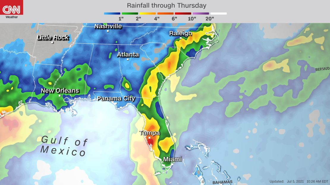
Rain is expected through Wednesday, with 4 to 6 inches possible in some locations. The heaviest rain will be on the southwest coast of Florida from Tampa to Fort Myers.
The east coast of Florida will see occasional rain bands and isolated storms. The threat for isolated tornadoes also exists for central and south Florida through Tuesday.
Storm surge of 1 to 2 feet will be possible in the Florida Keys Monday and Tuesday as the storm passes. Higher storm surge, up to 4 feet, is expected farther up the Florida Gulf coast.
“After Elsa clears Florida, it is expected to move faster north-northeastward across coastal Georgia and the Carolinas Wednesday and Thursday before moving over the western Atlantic,” said the NHC.
Minor impacts – gusty winds and 2 to 4 inches of rain – are expected in parts of Georgia and the Carolinas later this week.
This is the earliest an “E” named storm has ever formed in the Atlantic, outpacing the historic 2020 hurricane season.
Record heat in the west worsens drought, another heatwave on the way
Drought conditions have expanded and worsened in the West, particularly in the Pacific Northwest, after the record-breaking heat wave in late June, according to the latest US Drought Monitor.
Temperatures ranging from 20-30 degrees above average last week increased evaporation, “further drying out soils and vegetation,” the Drought Monitor wrote.
As of Thursday, drought conditions existed across 93% of the West, an all-time high – with nearly 60% in extreme or exceptional drought, the two most severe conditions.
Climate scientists say the historic drought and unprecedented heat are clear signals of manmade climate change, as greenhouse gas emissions push Earth’s temperature higher and higher.
The drought will only worsen as temperatures will once again climb to record numbers this week.

“Excessive and oppressive heat across the Northwest will continue through at least the first half of the week where daytime highs will climb well into the 90s and 100s,” the Weather Prediction Center wrote Monday.
More than 40 heat records are in jeopardy this week as temperatures climb to 15 degrees above normal for this time of year.
Heat waves as intense as the one that scorched the Pacific Northwest last week cause incredible amounts of water to evaporate. Large lakes such as Lake Mead outside of Las Vegas can lose more than 6 feet of water per year due to evaporation.
“That may not seem like much, but it equates to an average of nearly 300 billion gallons of water evaporating from Lake Mead every year,” said CNN meteorologist Pedram Javaheri.
“About 40% of that evaporation goes poof in the sizzling summer months of June through August,” said Javaheri. That’s enough water to supply 75,000 homes for an entire year in the Las Vegas Valley.
Here’s a look at the historic drought in pictures.
Read how insects are battling with cattle over food – and winning.
Seen from space
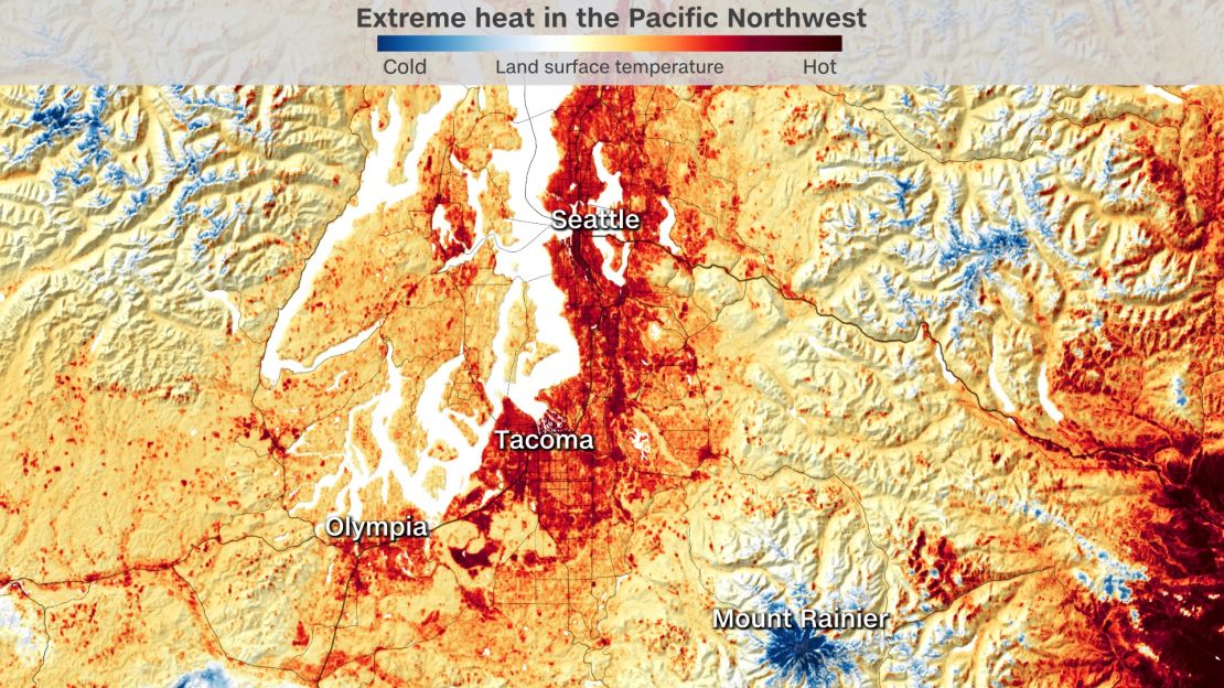
This incredible image of Washington state was captured by a NASA satellite during the heat wave in the Pacific Northwest last week.
NASA’s ECOsystem Spaceborne Thermal Radiometer Experiment on Space Station (ECOSTRESS) uses a scanning radiometer to measure thermal infrared energy emitted from Earth’s surface.
The image shows just how hot the surface of the Earth got during the heat wave. One interesting thing to note is that during a heat wave, the ground temperature can be much hotter than the air temperature.
According to this image, the ground temperature in Seattle got as hot as 120 degrees on June 25, and that was before the excessive heat moved in.
Weather in focus
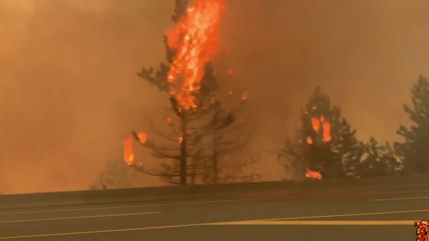
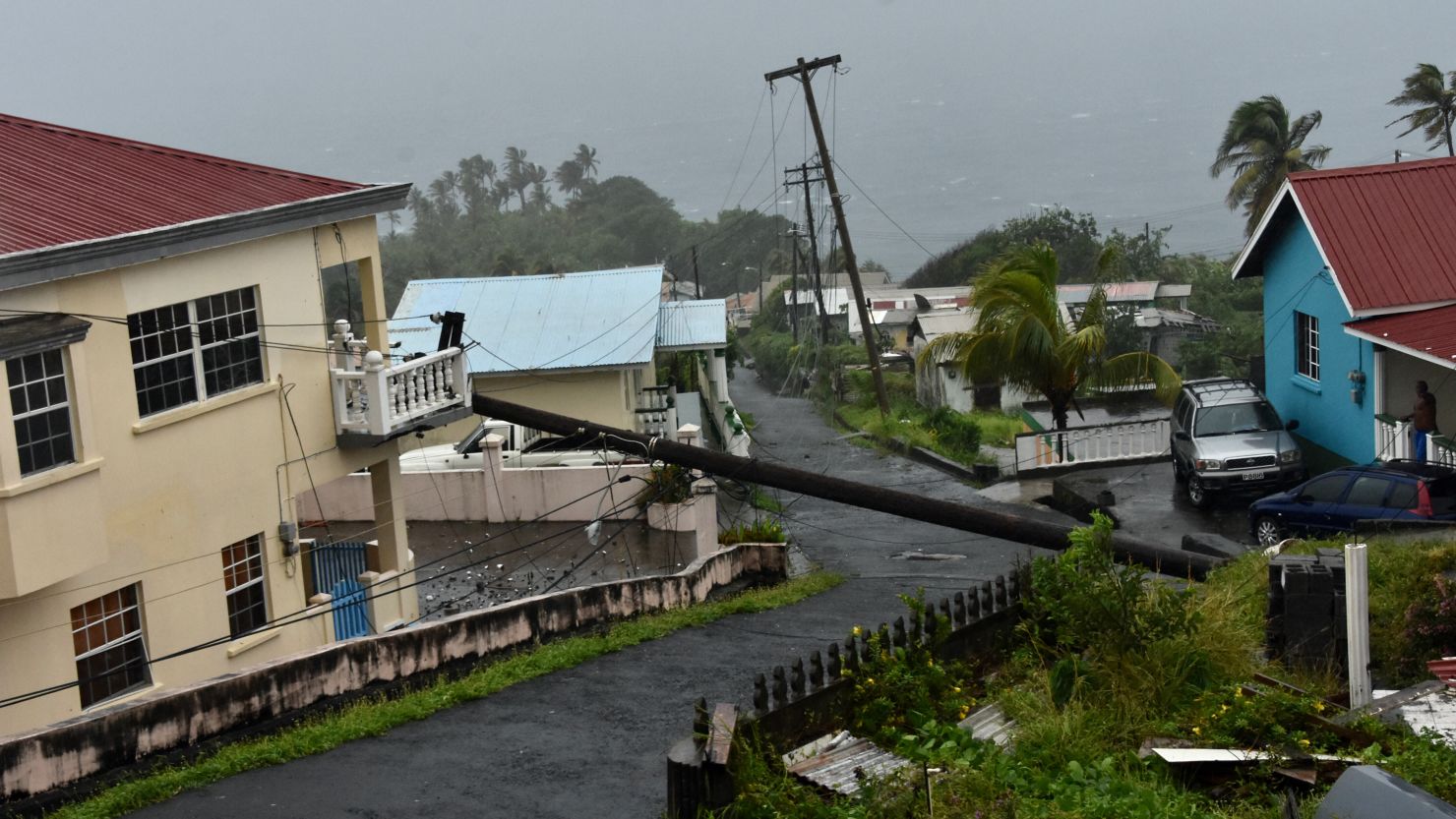
A fast-moving wildfire forced more than 1,000 people to evacuate and devastated the town of Lytton, Canada, one day after it recorded the nation’s all-time heat record.
Lytton Mayor Jan Polderman told CNN affiliate CTV News Friday that within minutes on Wednesday, “there was fire everywhere,” leaving no time to knock on doors and tell people to evacuate.
The fire destroyed “most homes and structures in the village” of Lytton and several residents are unaccounted for.
Read more about the wildfire here.
The weekly weather number
232
The number of all-time high temperature records broken during the peak of the historic heat wave in the Pacific Northwest and Canada.
The records were broken from Saturday, June 26, through Thursday, July 1. During that time, temperatures soared into the triple digits across the Pacific Northwest, running up to 40 degrees above normal. Excessive heat watches and warnings stretched all the way up to the Arctic Circle.
Weather proverb

“March comes in like a lion and goes out like lamb.”
While the saying most likely started as a reference to astronomy – referencing the position of the constellations Leo (a lion) and Aries (a ram, or lamb) in the night sky – it quickly evolved into a succinct summation of March’s changing weather as the seasons change from winter to spring in the Northern Hemisphere.
This proverb means that March is a month in which you can experience a lion’s fierce roar of frigid cold and the long white teeth of biting winds. At the same time, you can experience the warmth of fluffy white fleece and the innocent kiss of sunshine like a docile newborn lamb.
Typically across the US, the month of March is still in the grip of winter, providing more of the same brutal cold, wind and snow, especially in the first days of the month. But as the month moves along, it often leads to glimpses of spring’s beauty and warmth.
Read more about this proverb here.
CNN’s Haley Brink, Tom Sater, Dave Alsup and Brisa Colon contributed to this report.