Geomorphology
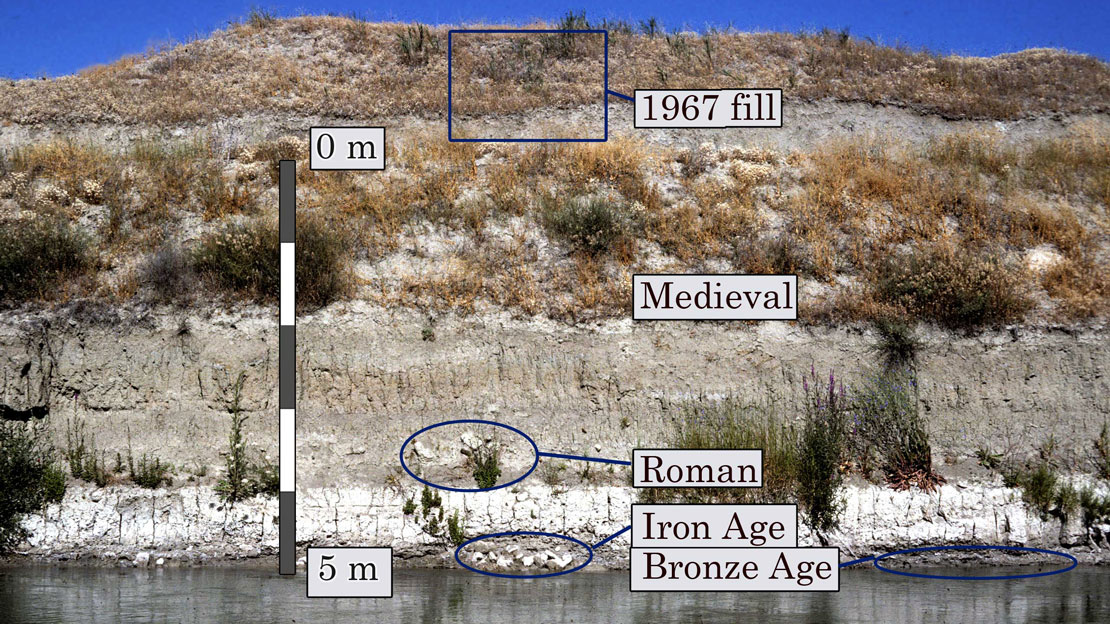
Geographical research at Gordion has shown that the Sakarya River buried much of the Iron Age city in 3–5 m of silt, beginning during its occupation, and then later eroded away major parts of it. The earliest major sedimentation at the city is dated to the late Bronze Age, when a widespread thin silt layer was laid out, upon which the Iron Age city was built. Subsequent river movements eroded away substantial portions of the city—including 2 km of the Lower Town wall. Buried and eroded parts of the site total three times the area now visible on the river plain. A very recent shift moved the river from the middle of the valley, east of the Citadel Mound, to the west side of the mound. Understanding the archaeology of Gordion beyond the raised Citadel Mound would be difficult without taking these changes into account, yet the magnitude of the geomorphic changes are not obvious from the surface, and they were not understood during the first four decades of archaeological research.

Because the river has recently been channelized to several meters below its floodplain, the site of Gordion provides an unusually clear display of the archaeology of a fluvially buried city. The lowest parts of the city were abandoned and decaying by the time most sedimentary burial was occurring. Gordion provides the most precise evidence to date about a widespread episode of sedimentation that affected central Anatolia after human settlement began, apparently caused by tree-cutting and over-grazing. The siltation of the Sakarya River was a basin-wide event. Sedimentary sequences nearly identical to the Sakarya floodplain deposits are seen 10 km downstream and 40 km upstream on the Sakarya, and more than 10 km upstream on the Porsuk River, the nearest major tributary.
The watersheds immediately adjacent to the city show the same sequence of erosion and stream-sedimentation as the river, although the small streams were affected many centuries earlier. All of this sedimentation was probably driven by large scale changes in human land use in central Anatolia beginning in the Bronze Age—specifically, a shift toward more intense grazing which followed the removal of trees for fuel and construction. Naomi Miller observed a decline in juniper, oak, and pine charcoal at Gordion by later Middle Phrygian times, after 700 BCE. Similar decreases in oak and juniper pollen beginning in the Bronze Age can be identified 350 km away in southeastern Anatolia. Grazing on the cleared land removes the low vegetation and increases erosion of soil into streams—as can be seen today on overgrazed lands near the site. Increasing the amount of fine-grain sediment in a river would cause it to deposit more sediment, raise its bed and floodplain, and meander more vigorously. The meandering movement of the aggrading Sakarya removed several segments of the Lower Town wall, probably well after the end of the Achaemenid period, creating the distinctively discontinuous pattern apparent today. Gordion’s Lower Town fortification wall was probably constructed primarily of mud brick—high but weak, and thus prone to stream erosion.
The Sakarya’s shift to its present course on the west side of the Citadel Mound was relatively recent. Although the river appears at the west of the mound in the earliest map of the site, by the Körte brothers in 1900, a 19th century date for the shift is consonant with the steep and uneven bed of that stream course. The river was still adjusting to its new path in 1967, at the time of the excavation of the present channelized stream.
Further reading
- Marsh, B. 2005. “Physical geography, human adaptation, and human impact at Gordion” in The Archaeology of Midas and the Phrygians: Recent Work at Gordion, ed. L. Kealhofer, Philadelphia, pp. 161-171.
- Marsh, B. 1999. “Alluvial Burial of Gordion, An Iron-Age City in Anatolia,” Journal of Field Archaeology 26, pp. 163-176.