Iron Age Gordion
Gordion is best known as the principal center of the Phrygians and their civilization, and as the ruling seat of the most famous Phrygian king, Midas. After a relatively modest Early Iron Age phase that may mark the beginning of Phrygian settlement on the Citadel Mound at Gordion (ca. 1200–950 BCE), the site took on a truly monumental character during the Early Phrygian period (ca. 950-800 BCE), indicating the emergence of a Phrygian state. We can trace the growth of Phrygian political power into the Middle Phrygian Iron Age (ca. 800–550 BCE) as reflected by architecture and the increasingly massive construction works. It was during this period, in the late eighth century under Midas, that Phrygian power reached its zenith.
The territory of Phrygia, as determined from the growing number of find spots of Phrygian inscriptions (eighth to fourth centuries BCE) and from information in Greek writers (fifth and fourth centuries BCE), comprised a very large area of Anatolia. As is now known, the Phrygian language was spoken from Daskyleion in the Marmara region of northwestern Turkey, eastward to Kerkenes in the Yozgat province of Central Anatolia, and as far south as Bayındır in Antalya province in Turkey’s Mediterranean region.
Early Iron Age Gordion (ca. 1200–950 BCE)
Around 1200 BCE many of the Bronze Age sites in central and south Anatolia were destroyed, including the Hittite capital Boğazköy-Hattusha. From the breakup of the Hittite empire a number of Iron Age successor states emerged.
Early Iron Age Gordion is known only from very limited, deep sondages on the eastern part of the Citadel Mound. A coherent picture has begun to emerge, however, suggesting a succession of villages with small, lightly constructed houses containing every-day, domestic kinds of items. Two phases have been identified. The earliest (Voigt’s YHSS 7B) is stratified directly above the Late Bronze Age level with no sign of a stratigraphic break to indicate a significant hiatus after the fall of the Hittites. Nevertheless, there are clear changes in architecture, domestic features, ceramics, and animal remains between the Late Bronze and the Early Iron Age.


Architectural change is represented by a number of “pit-houses,” which take the form of a shallow rectangular pit sometimes faced with flat stones. The walls above them were made from a framework of reeds and branches covered with mud plaster. A building from Voigt’s later Early Iron Age phase (YHSS 7A), the “Burned Reed House,” is larger with walls made of posts and reeds coated with thick mud plaster.
The ceramic finds do not support a gradual transition from the Late Bronze into the Early Iron Age; instead, the evidence strongly suggests a population change at this time, rather than simply a shift in political and economic organization. Few Early Iron Age sites have been excavated in Anatolia, but similarities in pottery (handmade shapes and specific details of incised or impressed decoration) point to a Thracian or more distant southeastern European origin for the immigrant group. This has been taken to mark the beginning of the presence of Phrygians, who reportedly migrated from Europe into Anatolia according to later Greek writers. The evidence also fits well with the current standard linguistic analysis of Phrygian as an Indo-European language with close links to Greek. Indeed, Phrygian appears to have been intrusive into Anatolia, where another, very different class of Indo-European languages—Hittite and Luwian—was dominant during the Bronze Age.
While there are subsequent changes in the succeeding Early Phrygian period at Gordion, including the appearance of additional pottery forms and wares perhaps deriving from the Balkans, there is strong overall cultural continuity down to the 8th century BCE, when writing begins.


Early Phrygian Gordion (ca. 950–800 BCE)
In the course of the tenth and ninth centuries BCE, a major transformation occurred, and through several successive building programs Gordion became a citadel with substantial fortification walls and monumental buildings. This dramatic change in the character of the site can be linked with the formation of a Phrygian political state, under a central authority that could oversee the organization necessary for such major works. The earliest of the excavated elite burial mounds, Tumulus W, was also built during this period, ca. 850 BCE. It is the second largest of all the Gordion tumuli, rising to an imposing height of 22 m. The young adult buried there, who was probably male, was obviously someone very important, and it is tempting to identify him as a member of the ruling family.
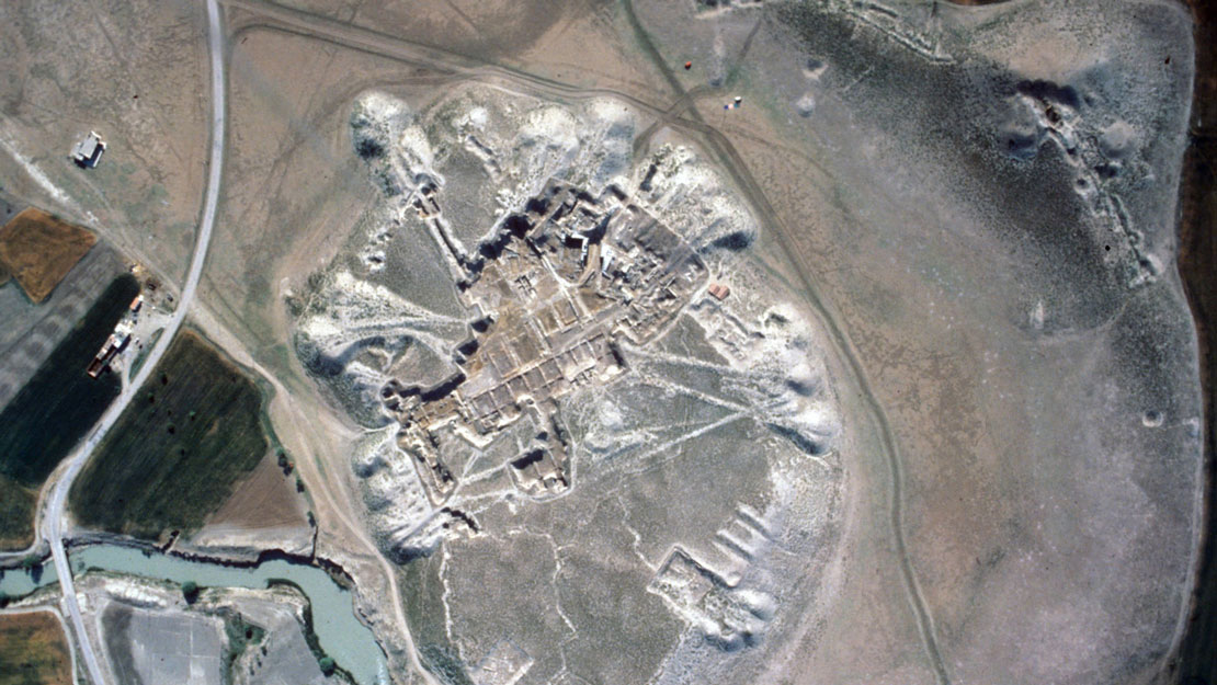
More than two hectares of the citadel complex have been excavated, located in the eastern part of Gordion’s Citadel Mound. The work has documented construction techniques, building plans, and a spatial arrangement of structures that we recognize as distinctively Phrygian. Part of this citadel was destroyed around 800 BCE in a great fire that spared the inhabitants but left numerous material remains in place. This Destruction Level is the only extensively excavated example of an early Iron Age political center in Anatolia, and it is primarily from these remains, and from the contents of wealthy, un-plundered tumuli dating to either side of the Destruction Level, that we gain our best picture of Phrygian material culture and economy. Ironically, although we know a great deal about the material culture of the people who occupied the Destruction Level, there are no historical texts to tell us who they were. They produced sophisticated architecture and technology, but the only possible text from this period is a graffito and its context is suspect. The range of imports, however, suggest ties with Neo-Hittite kingdoms to the east.
On Gordion’s Citadel Mound, the Early Phrygian citadel of the later 10th and 9th centuries BCE is the premiere showcase for monumental Iron Age architecture in Central Anatolia. On the southeast side of the mound is the only known gate complex leading into the citadel. It takes the form of a ramped approach-way, flanked by massive courts and leading to a double-doored gatehouse that had originally belonged to an earlier circuit. The stone walls beside the approach-way are still preserved to a height of about 10 meters, perhaps close to their original height. The northern court was at one stage of its history a roofed storeroom. The southern court has not been excavated. Away from the entry complex, stretches of the citadel’s fortification walls have been uncovered to the northeast, northwest, and southwest.


Within the citadel, two main districts have been unearthed. The Palace Area consists of two large courts open to the sky and divided by a thick partition wall. To the southwest of the courts lies the Terrace Complex, consisting of two long, multi-unit buildings facing each other across a broad street, all elevated on a terrace that is as much as two meters higher than the level of the Palace Area. The buildings along the southwestern side of the Palace Area (Megarons 1–4) and those in the Terrace Complex were all destroyed in the great fire that occurred around 800 BCE.
The building type of choice in the Early Phrygian citadel was the megaron, a rectangular structure with a large, deep hall fronted by a much shallower anteroom or porch. The type has a long history in Anatolia going back to the Early Bronze Age. The megarons of the citadel show a variety of sizes and building features. Among the smallest is Megaron 1, in the outer court of the Palace Area. The building’s walls are of mudbrick on a low stone socle. In the fire that destroyed the citadel around 800 BCE, the mudbrick became baked, leaving clear inserts, ledges, and hollows where wooden beams had originally been placed. This technique of half-timbering also has a long history in Anatolia.
Next to Megaron 1, Megaron 2 is a stone building that incorporates timbers in ways similar to those seen in its neighbor. Several features of this building are remarkable: the wildly-patterned pebble-mosaic floor of its hall; the elevated platform in front, as though to distinguish it from other buildings; figural and abstract designs incised on its external walls; and, from a structural point of view, an enormous span of 9.75 meters for the principal timbers of the roof. Found directly in front of the building, and perhaps belonging to it, is a stone roof-crown or akroterion, similar to those that have been sketchily incised on Megaron 2 itself. If there is to be a candidate for a temple in the Early Phrygian citadel, Megaron 2 is perhaps the strongest contender, and the Phrygian mother goddess Matar is the likeliest choice for the focus of adoration. Reliefs from Ankara, another Phrygian center, depict Matar standing in the doorway of a building bearing a similar akroterion, presumably her temple. In the Phrygian Highlands, to the southwest of Gordion, rock-cut building facades showing a similar kind of akroterion are also associated with the goddess.


Megaron 3, the largest single megaron in the citadel, faces onto the inner court of the Palace Area. Wooden beams set into its floor indicate that the hall had two rows of upright timber supports forming a central nave with side-aisles, and probably also balconies along the sides. Numerous textile remains along the rear wall suggest a low divan. The megaron contained a wealth of luxury items: much fine pottery, bronze vessels, and furniture with ivory and metal fittings and inlaid ivory plaques. Possibly the rulers of ninth century Gordion used Megaron 3 as a reception and audience hall, where in spacious surroundings they could display outward signs of their wealth and rank.
Megaron 4, elevated on a terrace beside Megaron 3 and approached by a monumental cobbled ramp, was the only building of the citadel that suffered major intrusions by later inhabitants of the site. Made largely of mudbrick, the building would have been prominent within the citadel, yet its purpose remains elusive. Like its neighbor, Megaron 3, the main hall has a nave and side-aisle arrangement.
The Terrace Complex to the southwest of the Palace Area consists of two long, multi-unit buildings facing each other across a wide street. The one toward the Palace Area, the Terrace Building, has been excavated for its entire length of over 100 meters, thus making it one of the largest buildings of ancient Anatolia. Its eight, virtually identical units have again the basic megaron plan, in this case sharing party walls. The interior arrangement of each unit recalls Megarons 3–4 in having two rows of pillars forming nave and side aisles. The walls consisted of stone and intermittent wooden coursing in their lower parts, with mudbrick above. Each unit was entered only by a door leading from the street into an antechamber; there were no internal doors connecting the units, nor rear doors giving access to the Palace Area.
Of the structure opposite, the CC (“Clay Cut”) Building, only three units have been excavated, but the basic plan of each is identical to the megaron-type units of the Terrace Building. The contents of these buildings reveal some of the activities that were carried out here. At low, mudbrick platforms, kneeling or squatting workers ground grain into flour using sets of grinding stones. Numerous spindle whorls suggest that others spun wool into thread or yarn. Still others wove fabrics on looms weighted by “doughnuts” made of unbaked clay, or used iron needles to sew fabrics together. The antechambers of the units served as kitchens, as indicated by large, beehive-shaped ovens of mudbrick and clay, and also by other kinds of cooking installations. The same activities were repeated in virtually all units of the Terrace Complex. In the absence of written records, one is left to guess the social and economic realities evinced by the Terrace Complex. Most of the workers may have been slaves or conscripts, and their activities could have formed part of a centralized palace economy wherein raw materials were brought to the citadel for processing and distribution.
Middle Phrygian Gordion (ca. 800–550 BCE)
The cause of the fiery destruction of the Early Phrygian Citadel ca. 800 BCE is unknown; whatever the source, the Phrygians had sufficient resilience to begin construction of a new citadel soon after the disaster. The project was a massive, well-planned undertaking, and one that involved not just the construction of new monumental buildings. The Phrygians decided to erect their new citadel at a considerably higher level than that of the old, as much as four to five meters higher in the area of the former megaron courts, and higher still around the entry gate at the southeast. To achieve the desired level, they brought in enormous amounts of clay and stone rubble. As the clay was being laid, so too were the deep rubble foundations of the intended new buildings. Thus, unlike the Early Phrygian citadel, which developed gradually over several generations, the New Citadel was conceived as a single plan. The effort was so great that it probably consumed several decades of the eighth century. Midas, active as ruler of Phrygia in the later eighth century, may have witnessed the completion of an ambitious project begun under his predecessors.
Comparison of the plans of the New and Old Citadels shows that the former largely duplicated the latter in terms of layout. At the southeast, a monumental gate complex in part overlay its Early Phrygian predecessor yet extended further toward the southeast. The massive rubble underpinning of the new gate was kept in place by a stepped retaining wall of multi-colored worked blocks that may have risen as high as 20 meters above the outside ground level. Creating a dramatic and impressive vista, the retaining wall no doubt also figured prominently in the defense of the New Citadel. Sections of the fortification wall for the New Citadel have been excavated at the northeast and northwest, where they lie just outside the line of the older citadel walls and, again, at a higher level.


Within the fortifications, the principal districts are virtually the same as in the old citadel: at the east, two large courts flanked by megarons, and, at the west, two rows of buildings facing each other across a wide street. The latter structures were now free-standing, whereas in the old citadel the so-called Terrace and CC Buildings had each been a multi-unit, single structure. Such an arrangement was probably intended to hinder the rapid spread of fire. A major addition to the layout of the New Citadel was Building A, a large, multi-unit row structure extending to the southwest of the gate complex. Building A would have risen atop the continuation of the stepped retaining wall in front of the gate complex; the row structure apparently presented a solid wall to the exterior, and thus could have served as part of the fortifications along this stretch of the New Citadel. In the sixth century BCE, and probably before the Persian conquest, a number of buildings must have been retro-fitted to receive terracotta tiled roofs and decorative revetment or frieze courses. Exactly which buildings underwent such remodeling is uncertain, since the terracottas were found scattered across the site, with no concentration large enough to suggest a connection to a particular building.
The large number of finds from the Destruction Level of the Old Citadel provided important information regarding the activities that took place within those earlier structures. For the New Citadel, however, no such destruction level exists to shed light on the use of the buildings. We can only surmise that the careful duplication of the old layout implies also a continuation of function, e.g., that the two rows of buildings at the west were centers for food and textile production, as we know to have been the case for the earlier buildings they overlie.
The New Citadel would have been the last line of defense within an extensive outer fortification system defending the Lower Town zone, spanning about one kilometer north–south and incorporating the mounds known today as Kuştepe (“Bird Mound”) and the Küçük Höyük (“Small Settlement-Mound”), sited respectively northwest and southeast of the Citadel Mound. Excavations at the Küçük Höyük revealed a high mud-brick platform 12 m in height, at least 50 m long and with a width of 10.25 m, on which stood a four-story mud-brick fortress/barracks complex of mud-brick reinforced with timber. A series of rooms was inter-connected by narrow doors and lit by large windows. Wooden stairways or ladders would have provided access to the upper stories, although no traces of such were found during the archaeological investigations.


Excavation of the mudbrick fortification walls on either side of the Küçük Höyük revealed they had a thickness of 3.50 m and an original height of 14 m or more, with square towers projecting from the outer face at intervals of ca. 16 m. Elsewhere on the circuit, whole sections of wall have been removed by erosion or buried by alluvial deposition in the flood plain of the river. However, recent magnetic prospection at key points has demonstrated that these walls reached as far as Kuştepe, which remains unexcavated, and continued past the west side of the Citadel Mound. The total area of the Lower Town protected by Gordion’s Middle Phrygian fortifications would therefore have been 25.44 hectares (254,400 square meters), which is considerably larger than formerly suspected. Magnetometry has also confirmed that the mound of Kuştepe covers a bastion that is probably of the same format and date as the one excavated at Küçük Höyük.
The Lower Town’s residential area was built on fill or an earth terrace adjacent to the massive fortification walls. Here were large stone buildings to the east and small mud-brick houses to the west.
To the northeast of the fortified Lower Town, on the same low ridge as the modern village of Yassıhöyük, and adjacent to the royal/elite tumuli there, excavations have revealed not only a Bronze Age cemetery but also the remains of an extramural Middle Phrygian settlement complex and—of later date but still within the Middle Phrygian period—a cemetery of lower social status than the tumulus burials of the elites.
The perimeter settlement complex was either contiguous with the extramural part of the city or was a discrete settlement zone beyond it. Several phases are indicated by a series of rebuilt structures. The buildings were of megaron design, similar to those on the Citadel Mound but smaller, with stone socles and mud-brick walls strengthened by wooden posts. The rooms were sometimes plastered, with stone pavements both inside and out. Internal installations included horseshoe-shaped hearths, ovens, and benches for grinding foodstuffs, bins of plastered mud brick, flat baking troughs, and small recessed storage areas. These and other finds indicate that food processing and textile production were primary activities, as in the citadel. A number of small cultic idols were also found in this area but had been re-deposited in later tumulus mantles that overlay some of the buildings; they presumably belonged to shrines within the settlement complex. Settlement activity here finally ended in destruction by fire around 700 BCE, in a military attack. Signs of crisis include the large amounts of material equipment hurriedly abandoned—pottery, metalwork and bone tools, spindle whorls and loomweights—and an unburied body in one of the burned buildings, shot with an arrow.


After the destruction of this settlement complex, the area was given over to the so-called “Common Cemetery” and to a number of small but elite tumulus burials, extending down to the sixth century BCE. The poorer burials of the Common Cemetery—furnishing rarely-found information on the more populous lower orders of Phrygian society— included single interments in cists, pits, jars, and earth graves (with or without stone covers), and finally, cremations. Grave gifts were sparse: of 112 cataloged graves, less than a third, 34, had even modest offerings. The full extent of this cemetery is unknown, but several hundred burials probably remain to be discovered. This part of the ridge again saw use as a cemetery in the Roman period.
It is during the life of the Middle Phrygian New Citadel that we have at Gordion our most plentiful evidence for Phrygian writing and religion. Numerous inscriptions, mostly incised on pottery after firing, attest to a degree of literacy in an alphabet closely related to that of the ancient Greeks. Statuettes in stone of a figure usually holding a cup and sometimes a bird no doubt represent the Phrygian mother goddess Matar. A stone relief shows her in a doorway, presumably that of her temple. Numerous statuettes of birds in stone and terracotta are probably connected with her cult.
In the late eighth century BCE, Phrygia was at the the height of its political and military power, under Midas, who challenged the Assyrians’ control over the westernmost parts of their empire. He is to be identified with Mita of the Mushki, who appears in Assyrian records at first as a dangerous adversary who organized anti-Assyrian resistance among the Neo-Hittite states of southeast Anatolia and later as a valuable ally of the Assyrian king, Sargon II.
If later accounts can be trusted, Midas had close personal ties with Greeks and their culture; according to Herodotos, he dedicated a throne to Apollo at Delphi, an object which was still extant in Herodotos’ day; and Aristotle claimed that he married a woman from the East Greek city of Kyme. Contact with the Greeks during the Middle Phrygian period is archaeologically documented by the import of Greek pottery, perfume, and wine to the site, and by the presence of a number of Phrygian bronze objects in both Mainland and East Greece. The Greeks themselves borrowed freely from the Phrygians, adopting both the cult and the iconography of the goddess Matar. Cultural and commercial interchange between the Greeks and Phrygians was no doubt facilitated by Greek colonization, which by the seventh century BCE made the two peoples neighbors along the Propontis (the Sea of Marmara).


Very late Classical chronological sources give dates of 696 or 675–674 BCE for Midas’ death, but those dates are demonstrably untrustworthy. Also dubious is an account by the early Roman-era writer Strabo that there was an invasion of Phrygia by the nomadic Kimmerians during the time of Midas, an invasion that provoked his suicide. The report is contradicted by other Classical accounts, which mention very different circumstances for his death. The latest reliable information concerning Midas is the indication in the Assyrian records that he was still in power in 709. There is no excavated tumulus at Gordion that can be plausibly identified as Midas’ burial place, but particular contexts, including minor tumuli, can be dated to his time, in part through the help of associated Greek pottery.
Textual evidence from the Greek writer Herodotus suggests that Gordion had passed from being the capital of an independent Phrygian state (at least through the reign of Midas) to becoming dominated by the west Anatolian kingdom of Lydia, with its capital at Sardis, in the first half of the sixth century BCE if not earlier. By 585, the smaller Phrygian area east of the Kızılırmak River (the ancient Halys) had passed under Median control.
Excavations at Gordion dramatically revealed that the Lower Town’s defensive installation, now called the Küçük Höyük, was destroyed by fire following a siege, an event that can be linked to the successful Persian conquest of Lydia by king Cyrus II “The Great” in the 540s BCE. The assault ramp built by the Persians to gain access to the city is still preserved on the southeast side of the Küçük Höyük, and numerous traces of the attack were recovered during the excavation: hundreds of arrowheads (predominantly two-flanged), many of which were buried in the faces of the walls. At the time of its destruction, the fortress occupants were using primarily Lydian instead of Phrygian pottery, suggesting that the site was indeed a Lydian garrison.


Tumuli at Gordion
Greek and Roman writers preserved a tradition that Gordion was the seat of the Phrygian kings, and its role as a capital during at least some of Phrygia’s history is borne out by the large number of tumuli—earthen mounds covering the burials of the society’s elite—that are the most visually striking feature of the site today. Nowhere else in Phrygia are there so many tumuli that reach such a large size. In all of Anatolia there is only one comparable group, in a city that was itself a capital: Sardis, the west Anatolian home of the Lydian kings.
There are about 100 tumuli in the Gordion area. They range in size from small, nearly imperceptible humps, to the largest example that still stands some 53 m high after 2700 years of erosion, and is visible from miles away in the valley of the Sakarya River. This tumulus has been designated Tumulus MM, and is more than twice as high as the next tallest, which stands 22 m high (Tumulus W). 39 of these tumuli have been investigated archaeologically: five by the Körte brothers in 1900, 31 by the Americans, and four by The Museum of Anatolian Civilizations, Ankara.
The burials range in date from the Early Phrygian period (ninth century BCE) to Hellenistic times. Inhumation burials are the rule in the earliest tumuli, but cremation burials appear at the end of the seventh century BCE. The occupants of the tombs can be male or female, and range in age from a child of 4–5 years old (Tumulus P) to an older adult in his early 60s (Tumulus MM). All of these tumulus burials are many steps above the common cist grave provided for most of the population of ancient Gordion, and this holds true for the grave goods included in the burials as well.


The tumuli with wooden tomb chambers from the Early and Middle Phrygian periods have generally similar designs. First, a rectangular pit intended to contain the tomb chamber was dug 1–2 meters deep. The base of the pit was normally lined with stone or gravel, but occasionally it was nothing more than hard-packed earth. The tomb chamber itself was essentially a flat-topped box, made from large pine or juniper timbers, usually with a wooden floor (though the base of the pit could serve as well). The interior spaces range from about 2 m square to 6.15 x 5.10 m (Tumulus MM), all of which provided room for some form of wooden coffin as well as an array of grave goods.
The timbers were joined without fasteners, using various kinds of housed or lap joints (with the occasional mortise and tenon joint). The tomb chambers were held together by the joinery, by gravity (with squared timbers stacked on top of one another), and by the pressure of stone packing that filled the space between the tomb chamber and the walls of the pit. Before the roof was installed, the burial proper would take place: the coffin was lowered into the chamber; the body was placed inside; and the grave goods were arranged around the body in the coffin, on the floor, and (occasionally) on the walls and beams, suspended on iron spikes. The roof of the chamber would be a single or double layer of wooden beams, and then a mound of stone rubble would be piled on top. Above this would be built the mantle of the tumulus, frequently with a sealing clay layer directly above the stone pile, then normal earth to create the final shape and height of the tumulus.
Today, the only tomb chamber from this period still visible is the one in Tumulus MM, which is exceptional in every respect. It is the largest tumulus, and it covers the largest tomb chamber. Its roof is double pitched, like the roofs of the Phrygian megaron (the roof design on these is known from the Gordion “doodle stones” from Megaron 2, and from the rock-cut façades in the Phrygian highlands to the west of Gordion). The pit that would normally hold the tomb chamber was lined with roughly trimmed limestone blocks and completely filled with stone rubble.


On top of the rubble fill was a layer of juniper timbers, trimmed flat on top to receive the lap-jointed pine timbers that created the tomb chamber floor. The squared pine wall beams were positioned on top of the floor, and outside the wall was set an outer casing of rough juniper logs. The space between the interior wall and the juniper logs of the outer casing was filled with rubble, as was the space between the juniper logs and the upward extension of the limestone wall that lined the pit. All of this was built up in concert, along with at least enough of the tumulus fill to support the entire interior system (the limestone wall was not designed as a retaining wall). The three roof support systems were constructed from pairs of pine beams stacked one on top of the other, with two more pairs of timbers trimmed in place to create the angles for the gabled roof.
It was at this point in the construction of the tomb that the burial of the dead king took place. A banquet was held in his honor, and the coffin, body, and grave goods were lowered into the tomb chamber. While no gold was discovered in the tomb, the grave offerings were large in number and spectacular in quality. Among the items found in the tomb were three large bronze cauldrons; 166 bronze bowls, ladles, and pitchers; 172 bronze fibulae (clothing or safety pins); nine three-legged wooden tables; and two large inlaid wooden serving stands. Seventy objects were originally suspended on L-shaped iron spikes on three walls, but all fell to the floor as the spikes rusted through.
With the final arranging completed, the mourners climbed out of the tomb, and the chamber was covered and sealed by two rows of squared pine beams, capped by the ridge beam, which measures nearly 11.5 m long. A secondary roof of juniper logs was built across the ridge beam, and the whole wooden tomb chamber complex was finally covered by more rubble. Above this, clay and earth were piled and packed higher and higher, until the tumulus was completed (and higher than it now stands after 2700 years of erosion).
Excavated by Rodney Young in 1957, Tumulus MM is easily the most studied of all the tumuli at Gordion. Peter Kuniholm of Cornell University began his dendrochronological studies on timbers from the tomb chamber. The latest scientific date for the juniper logs surrounding the tomb chamber proper is around 740 BCE. Assuming that the juniper logs were cut and trimmed for use in this tomb, they provide the best absolute date for the construction of the tomb. And if 740 BCE is the date of the tomb, it is too early for Midas, who is historically attested as late as 709 BCE. Tumulus MM could, however, have been the tomb of Midas’ father Gordios. If so, it would have served as the new king’s first major building project, and his name has continued to be attached to the mound by virtue of its modern nickname: Tumulus MM, the Midas Mound.
Since the 1980’s, team members at Gordion have been monitoring the environment and structural stability of the tomb chamber. Electronic dataloggers record temperature and humidity levels throughout the year. Readings of calibrated “telltales” at the corners of the outer casing are recorded by the Gordion Museum staff each month throughout the year, and measurements are taken at fixed points in the interior of the tomb chamber. All these efforts and professional engineering studies led to the installation in 2002 of a new support system for the juniper logs of the outer casing. It is all part of our goal to study, document, protect, and preserve the tomb chamber in Tumulus MM, the oldest standing wooden building in the world.
Further reading
- Kohler, E. L. 1995. The Gordion Excavations (1950-1973) Final Reports, Volume II. The Lesser Phrygian Tumuli, Part 1: The Inhumations, Philadelphia.
- Sams, G. K. 2005. “Gordion: Exploration over a Century,” in The Archaeology of Midas and the Phrygians. Recent Work at Gordion. ed. L. Kealhofer, Philadelphia, pp. 10–21.
- Voigt, M. M., and R. C. Henrickson. 2000. “Formation of the Phrygian State: The Early Iron Age at Gordion,” Anatolian Studies 50, pp. 37–54.
- Voigt, M. M., and Young, T. C. Jr. 1999. “From Phrygian Capital to Achaemenid Entrepot: Middle and Late Phrygian Gordion,” Iranica Antiqua 34, pp. 192–240.
- Young, R. S. 1981. The Gordion Excavations (1950-1973) Final Reports, Volume I. Three Great Early Tumuli. Philadelphia.