Showing posts with label central african republic. Show all posts

Friday, June 10, 2022

Central African Republic Control Map & Timeline - May 2022 (Subscription)

SUBSCRIBERS CLICK HERE TO VIEW FULL ARTICLE AND MAP:
Old Portal (members.polgeonow.com) | New Portal (controlmaps.polgeonow.com)


(To see other maps of this conflict, view all Central African Republic articles on PolGeoNow.) 

Research by Djordje Djukic, with additional reporting by Evan Centanni. Map by Evan Centanni and Djordje Djukic

Subscribe for full access to all conflict map reports!

Thumbnail preview of Central African Republic conflict: 2021 map of rebel and government control. Updated to June 5, 2022, showing territorial control by the CAR government (with Russian Wagner Group mercenaries and the UN's MINUSCA peacekeeping force), CPC rebel coalition (FPRC, UPC, MPC, 3R),  other ex-Séléka rebels (RPRC, MLCJ), Anti-balaka militias, and other armed groups such as Joseph Kony's Lord's Resistance Army (LRA). Colorblind accessible.

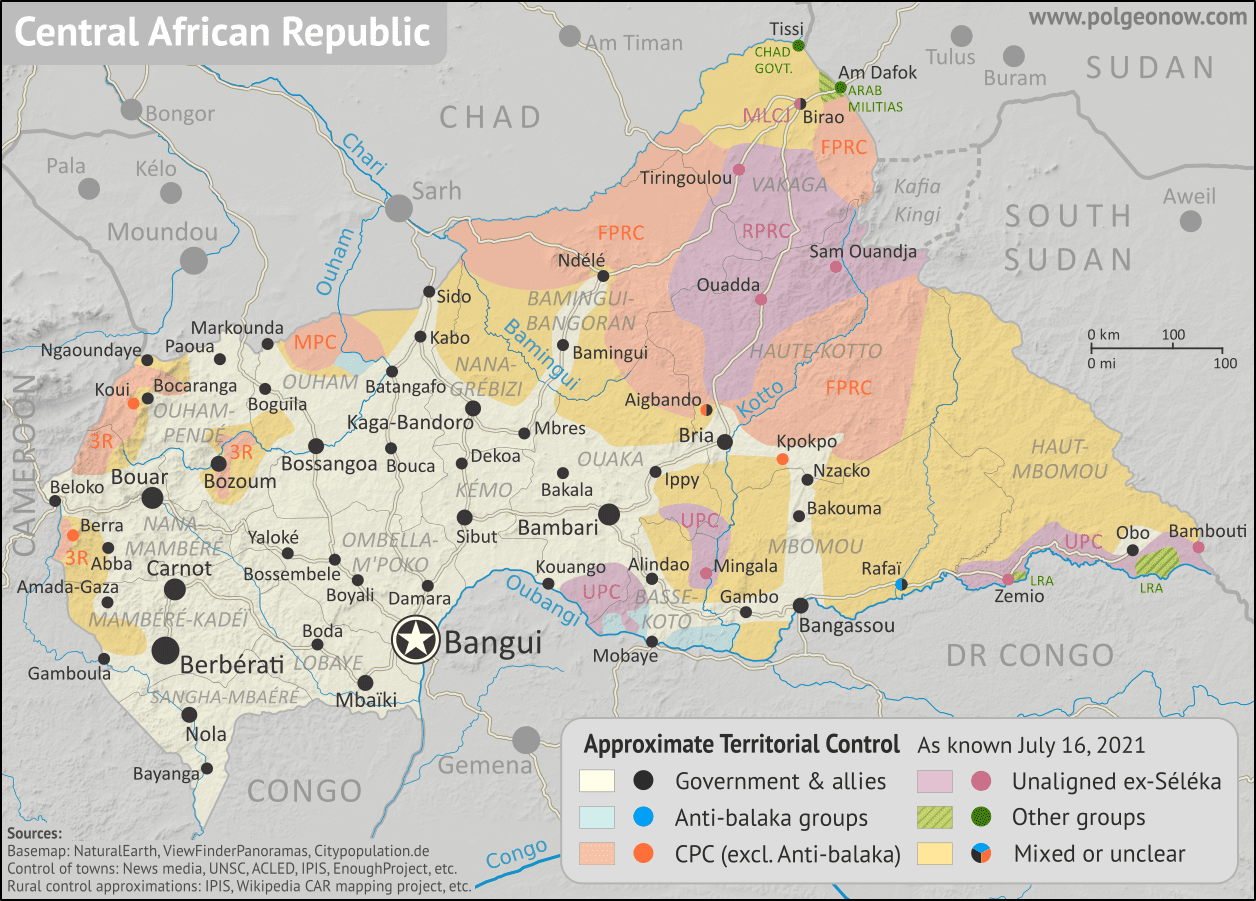
Pro-government forces led by the Russian Wagner Group have accelerated their campaigns in the eastern CAR, carving out new chains of government-held towns deep inside the once-rebel-dominated northeast. Meanwhile, the UPC, perhaps the country's most powerful rebel faction, has rejoined the larger anti-government coalition.

See all this and more on the latest update to PolGeoNow's concise, professional CAR control map, which includes a timeline of changes since our previous CAR map report of July 2021, with sources cited.


This map and report are premium content, available to paid subscribers of the PolGeoNow Conflict Mapping Service.

Want to see before you subscribe? Check out our most recent FREE SAMPLE Central African Republic control map!

Exclusive map report includes:

  • Up-to-date illustration of current territorial control in the Central African Republic, color-coded for the government and allies, the CPC rebel coalition, "Anti-balaka" militias, and other rebel groups, with areas of uncertainty indicated. Colorblind accessible.
  • Detailed indication of city-by-city control, including key towns and other locations important to current events
  • Locations of recent control changes and other important events, including Tiringoulou, Ouanda Djallé, Nzakoundou, Nzacko, Kaita, and more
  • Detailed timeline of important events and changes to territorial control since July 15, 2022, with links to sources.

SUBSCRIBERS CLICK HERE TO VIEW FULL ARTICLE AND MAP:
Old Portal (members.polgeonow.com) | New Portal (controlmaps.polgeonow.com)


Not signed up yet? Click here to learn more about our professional subscription service!

Can I purchase just this map?
This map and report are not available for automated purchase to non-subscribers. If you need access or republication rights for only this map report, contact service@polgeonow.com for options.

Tuesday, July 20, 2021

Central African Republic Control Map & Timeline - July 2021

There are newer versions of this map available. To see them, view all Central African Republic articles on PolGeoNow. 

We've revived and relaunched our coverage of territorial control in the Central African Republic, one of PolGeoNow's original areas of reporting from back in 2013. The timeline in this article covers the entire period from then up to now, and going forward, our newly-redesigned map will be updated as needed. To ensure your access to future updates, sign up for our conflict mapping service.

Central African Republic conflict: 2021 map of rebel and government control. Updated to July 16, 2021, showing territorial control by the CAR government, CPC rebel coalition (FPRC, MPC, 3R),  other ex-Séléka rebels (UPC, RPRC, MLCJ), Anti-balaka militias, and other armed groups such as Joseph Kony's Lord's Resistance Army (LRA). Colorblind accessible.
Map by Evan Centanni and Djordje Djukic. Terrain data sourced from ViewFinderPanoramas.
Contact us for permission to use this map.

(Subscribers click here to view this article in the member area)

Timeline by Djordje Djukic and Evan Centanni

Who controls the Central African Republic in 2021?

Since PolGeoNow's last coverage of rebel control in the Central African Republic back in 2013, the country's civil war has continued all the way until today, but with some major reconfigurations. The Séléka rebel coalition, officially disbanded after it took over the country's government in 2013, has undergone a long series of fragmentations and reconstitutions since stepping down from full control of the country in 2014. Perhaps more surprisingly, many of the ex-Séléka groups have teamed up with their once-bitter enemies - militias of the Anti-balaka movement - to form a unified front against the country's internationally-backed government, which sees both of them as unwelcome rogue elements.

Thursday, February 2, 2017

Morocco Joins African Union; CAR Un-suspended (Map)

African Union: Map of Africa showing which countries are in the African Union, including active and suspended member countries, updated for the January 2017 admission of Morocco as a member, as well as the April 2016 lifting of the Central African Republic's (CAR) suspension (colorblind accessible).
Map by Evan Centanni, from this blank map by Eric Gaba. License: CC BY-SA
(Subscribers click here to view this article in the members area.)

Article by Evan Centanni

Morocco Rejoins AU after Long Absence

The North African country of Morocco became the 55th member of the African Union (AU) this week, after member countries voted to let it back into the organization after 33 years on its own. Morocco withdrew from the Organisation for African Unity (OAU), an earlier version of the AU, in 1984. The AU now includes every independent country in Africa, not counting the unrecognized breakaway state of Somaliland. The last country to join was South Sudan, which became a member three weeks after declaring independence in July 2011.

Friday, October 9, 2015

African Union Suspends Burkina Faso, Then Reinstates it Again (Map)

Map of the African Union, including active and suspended member countries, updated for the September 2015 suspension and reinstatement of Burkina Faso (colorblind accessible).
Map by Evan Centanni, from this blank map by Eric Gaba. License: CC BY-SA
Premium members click here to view this article in the ad-free members area. Not a member yet? Subscribe now!

Article by Evan Centanni

Coup Crisis
On September 18, Burkina Faso was suspended from the African Union (AU) by the organization's Peace and Security Council. The action was in response to a government takeover by soldiers loyal to the country's former president Blaise Compaore, who was pushed out in a popular uprising a year ago.

Friday, September 27, 2013

Central African Republic: Towns Retaken by Government-allied Forces (September 2013)

There are newer maps of this conflict available. To see them, view all Central African Republic articles on PolGeoNow. 

Map of control in the Central African Republic's anti-Seleka counter-rebellion, including towns of Bouca and Bossangoa
Counter-rebels briefly captured at least one Central African Republic town in September (click for full map and article). Map by Evan Centanni from this map by Wikimedia user Keitsist. License: CC BY-SA
Territory Nominally Reunited
Two weeks ago, Political Geography Now reported on rebel control in the Central African Republic's new counter-rebellion. Since then, the towns of Bouca and Bossangoa have reportedly both been recaptured by forces belonging to Séléka, the former rebel coalition whose leader is now the president of the Central African Republic.

However, as outrage grows over vicious violence against civilians which has continued since Séléka's campaign to take over the Central African Republic earlier this year, the new President Michel Djotodia has little actual control over the country.

One another analyst says that "law and order stops outside the presidential palace" in Bangui, and the AFP reported earlier this month that "A large number of [Séléka] fighters answer only to their direct leaders, who have carved out personal fiefdoms in the wake of the rebellion". This raises serious questions regarding President Djotodia's claims that he is now dissolving and outlawing the Séléka organization.

More information: Rebel Control Map: Central African Republic's Counter-Rebellion

To see Séléka's rise to power illustrated in rebel-control maps, view all Central African Republic articles.

Wednesday, September 11, 2013

Rebel Control Map: Central African Republic's Counter-Rebellion (September 2013)

Map of 2013 counter-rebellion in the Central African Republic, showing current control by anti-Séléka (possibly pro-Bozizé) rebels as known on September 11, 2013.
Little sooner than Séléka rebel leader was sworn in as president, a new counter-rebellion has sprung up in the Central African Republic. Map by Evan Centanni from this map by Wikimedia user Keitsist. License: CC BY-SA
Previously: Séléka Coalition Takes Control of Central African Republic (Map of Rebel Advance)

Rebellion and Counter-Rebellion
Starting last December, a rebel coalition called Séléka swept across the Central African Republic from the north, capturing much of the country by January (see our first map of rebel control in the CAR). After a short-lived attempt at peace, Séléka renewed its campaign, capturing the capital and forcing President François Bozizé to flee the country. Rebel leader Michel Djotodia declared himself president, and Séléka has remained the major power in the country despite outbreaks of violence and general chaos.

Friday, March 22, 2013

Central African Republic: Map of Rebel Advance to Capital (March 2013)

Last January, rebels in the Central African Republic agreed to a ceasefire with the government, after taking over much of the country. Now, despite the formation of a unity government, the ceasefire has broken down and the rebels are once again advancing on the capital and other towns. Read on for a summary of events. Update (March 24, 2013): The Séléka rebel coalition has now taken the national capital, Bangui.
Map of 2012-2013 rebellion in the Central African Republic, showing current rebel control as of March 24, 2013, from the breakdown of the ceasefire up to the capture of the national capital city, Bangui
Advance of Séléka rebels in the Central African Republic, highlighting attacks occurring since the Jan. 11 ceasefire. Map fact-checked and expanded by Evan Centanni from this map by Wikimedia user Keitsist. License: CC BY-SA
Original Article: Central African Republic - Map of Rebel Control

Ceasefire Violations
After reaching a ceasefire with the government on January 11th, the Central African Republic's Séléka rebel coalition began integration into a new unity government, with several rebel leaders receiving prominent positions in President François Bozizé's cabinet. However, the violence did not end completely.

Thursday, February 7, 2013

Central African Republic Rebels Join Government (February 2013)

Map of rebel control in the Central African Republic, updated for the reported occupation of Dimbi and Kembe towns after the January 2013 ceasefire
Updated Central African Republic rebel control map. Fact-checked and modified by Evan Centanni from this map by Wikimedia user Keitsist. License: CC BY-SA
Unity Government Announced
After taking control of much of the country in December and January, rebels in the Central African Republic have been given a place in a new unity government that was announced last Sunday. The formation of this government will officially end the country's period of division between the old administration and the "Séléka" rebel coalition.

However, it remains to be seen whether the Central African Republic will truly be reunited in terms of the facts on the ground. Insecurity and chaos has continued at reduced levels since the ceasefire of January 11, with one band of rebels even attacking two more towns during the interim (see updated map at right).

For the full story of Séléka's lighting-fast campaign to control the country, see our previous article Central African Republic: Map of Rebel Control.

Updated Map: Central African Republic - Map of Rebel Control (March 2013)

Thursday, January 10, 2013

Central African Republic: Map of Rebel Control (January 2013)

Last month, rebels in the Central African Republic launched a sudden military campaign against the government, rapidly taking over city after city in their advance towards the capital. Fighting has now come to a temporary halt, with much of the country under rebel control. Read on for a summary of the conflict so far. 

Map of 2012-2013 rebellion in the Central African Republic, showing current rebel control as of January 11, 2013
Advance of Séléka rebels in the Central African Republic during December 2012 and January 2013. Map fact-checked and modified by Evan Centanni from this map by Wikimedia user Keitsist. License: CC BY-SA
Updated Map: Central African Republic - Map of Rebel Control (March 2013)

Rebellion in the Central African Republic
In 2007, a three-year civil war came to an end in the Central African Republic (CAR) when the government reached a peace agreement with several rebel groups. Yet six years later, some of the rebels feel that the government has still not honored its side of that agreement, and last month violence broke out once again.

The new fighting was initiated by a coalition of rebel groups calling itself "Séléka", which means "alliance" in Sango, the national language of the CAR. The rebels have threatened to depose President François Bozizé, who took power in a 2003 coup but has since won two controversial elections.