Showing posts with label uk. Show all posts

Friday, September 9, 2022

King Charles's 15 Countries: The Commonwealth Realms

Did you know the new King Charles III isn't just the King of England and the larger UK, but of 14 other independent countries? If that statement just raises more questions for you, read on for all the answers...
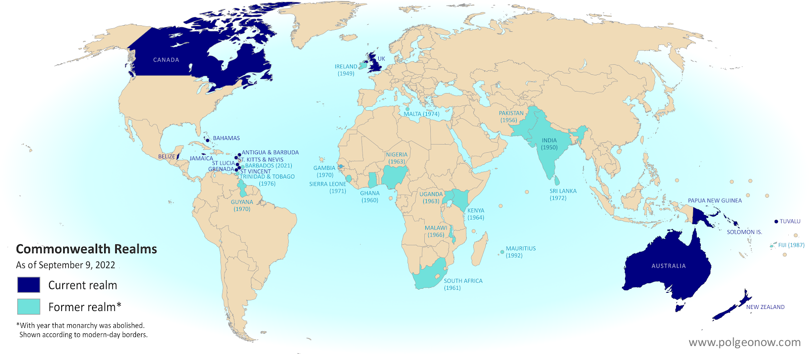
Map of countries with King Charles III as head of state, which are known as the Commonwealth realms. Includes the UK, Canada, Australia, and a number of small countries in Oceania and the Caribbean. Also shows former Commonwealth realms, including large parts of Africa and South Asia. Colorblind accessible.
Map of the Commonwealth realms (independent countries that share the monarchy with Britain). Click to enlarge. Contact us for permission to use this map.


This article, originally written during the reign of Queen Elizabeth II, has been revised and updated to for the passing of the throne to her son, King Charles III.

Which countries does King Charles reign over?

You might be surprised to learn that King Charles III is the official king of 15 different independent countries. Those countries are together known as the "Commonwealth realms" - a smaller subset of the Commonwealth of Nations, which also includes many kingless republics. Every one of the 15 Commonwealth realms is considered a fully-fledged independent country and a member of the UN, despite sharing the same monarch. 

Saturday, December 4, 2021

Queen Elizabeth's 15 Countries: The Commonwealth Realms

Did you know Elizabeth II isn't just the Queen of England and the larger UK, but of 14 other independent countries? If that statement just raises more questions for you, read on for all the answers...

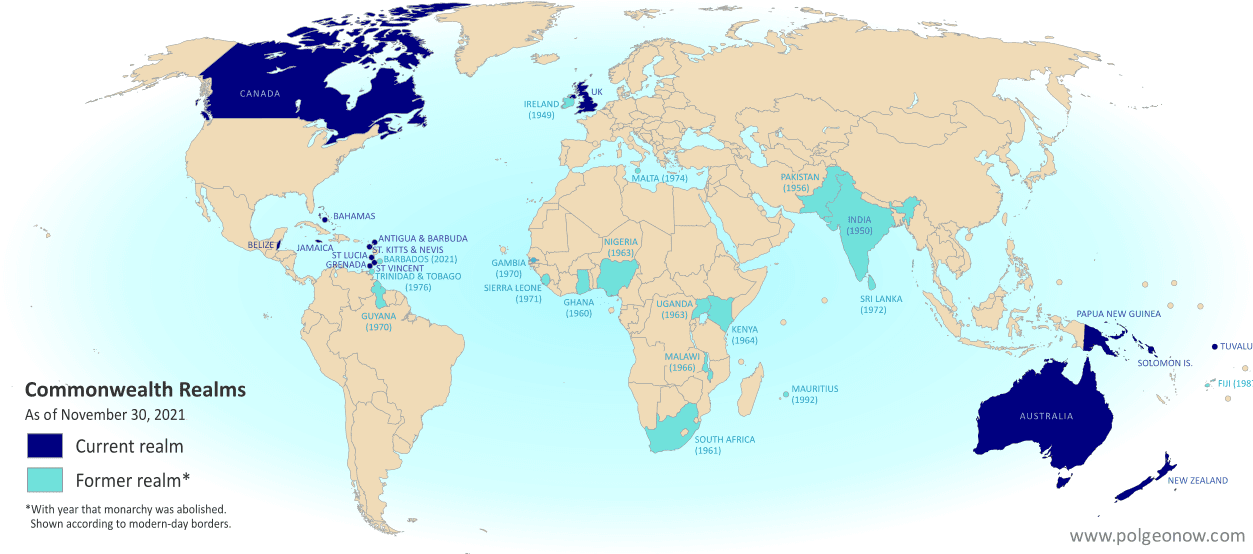
Map countries with Queen Elizabeth II as head of state, which are known as the Commonwealth realms. Includes the UK, Canada, Australia, and a number of small countries in Oceania and the Caribbean. Also shows former Commonwealth realms, including large parts of Africa and South Asia. Colorblind accessible.
Map of the Commonwealth realms (independent countries that share the monarchy with Britain). Click to enlarge. Contact us for permission to use this map.


This article, originally from 2012, has been revised and updated for the abolition of Barbados's monarchy in November 2021, which reduced the number of countries Queen Elizabeth II reigns over from 16 to 15.

Which countries does Queen Elizabeth reign over?

You might be surprised to learn that Queen Elizabeth II is the official queen of 15 different independent countries. Those countries are together known as the "Commonwealth realms" - a smaller subset of the Commonwealth of Nations, which also includes many queenless republics. Every one of the 15 Commonwealth realms is considered a fully-fledged independent country and a member of the UN, despite sharing the same monarch. 
Saturday, February 8, 2020

Brexit: UK Leaves European Union (Plus: What Actually Changed?)

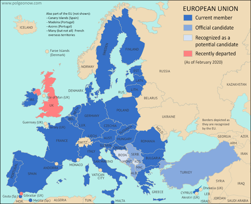
Map of the European Union, including all member countries, official candidate countries, and potential candidate countries, as of February 2020, updated for Brexit - the departure of the UK and Gibraltar (colorblind accessible). Also file under: Map of European Union Member Countries.

Map by Evan Centanni, from blank map by Ssolbergj. License: CC BY-SA

Britain Finally Exits EU

Last week, the United Kingdom of Great Britain and Northern Ireland - "UK" or "Britain" for short - became the first country ever to formally leave the European Union (EU).

This marks the turning point, but not the end, of the years-long saga nicknamed "Brexit" (short for "British exit"), which started with a 2016 referendum.

The long-delayed official exit finally arrived in the first second of February 1, 2020 at the EU headquarters in Belgium. Because of a time zone difference, this was 11:00 pm of January 31 in the UK. But because of a negotiated "transition period", most practical changes won't go into effect until at least the end of this year (read on for more about that).

The British territory of Gibraltar, located along the southern coast of Spain, was also pulled out of the EU alongside the UK.

How it Happened: A Concise Timeline of Brexit

Map of the European Union, including all member countries, official candidate countries, and potential candidate countries, as of February 2020, updated for Brexit - the departure of the UK and Gibraltar (colorblind accessible). Also file under: Map of European Union Member Countries.

Map by Evan Centanni, from blank map by Ssolbergj. License: CC BY-SA

UK Leaves EU: What Were They Doing All That Time?

Last week, the UK actually left the European Union, in a long-anticipated move called for by a referendum vote in 2016. This British exit, or "Brexit" was never meant to happen in less than two years - by how did it stretch out to almost four?

We've put together a clear and concise timeline summarizing the process, without any of the confusing technical lingo or agonizing political details. Enjoy!


Friday, June 23, 2017

Why Brexit Matters: 5 Things That Might Change When Britain Leaves the EU

By Bryn Jansson

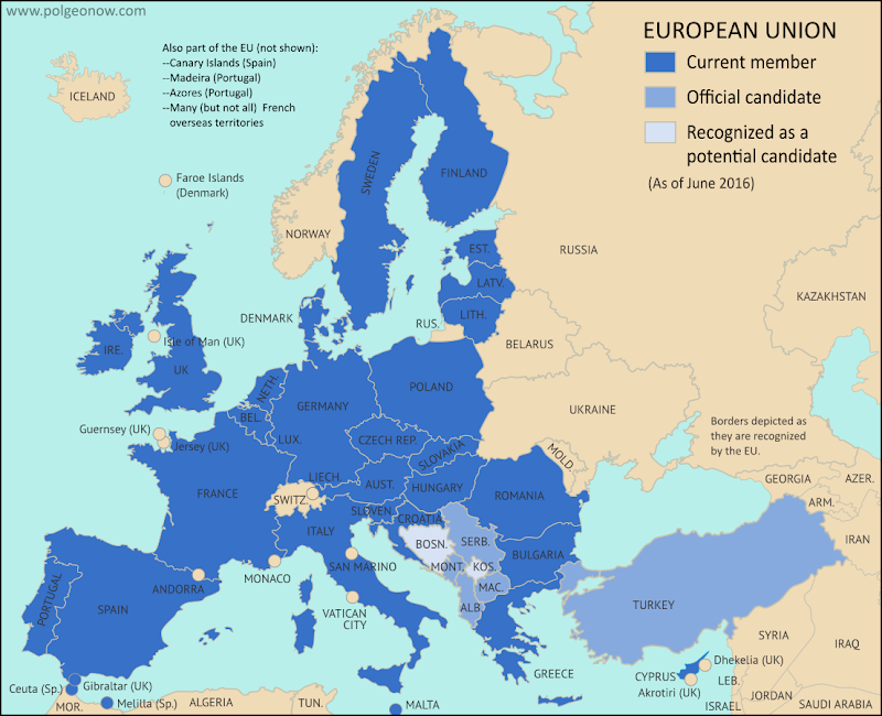
Map of the European Union, including all member countries, official candidate countries, and potential candidate countries, as 2017 (colorblind accessible).
Map of current and future EU member countries

Brexit Process Finally Begins

The United Kingdom (UK) and the European Union (EU) began formal divorce negotiations in Brussels last Monday, June 19, starting a 21-month sprint to the March 2019 Brexit deadline. ("Brexit" is short for "British Exit" from the EU, since "Britain" is another name for the UK.)

UK voters’ surprise choice to leave the EU happened exactly a year ago, on June 23, 2016 - but it didn’t automatically trigger the two-year countdown clock on exit negotiations necessary for departure under Article 50 of the EU’s Lisbon Treaty.


Friday, June 24, 2016

UK Votes to Quit EU: Map of How Britain Voted in the Brexit Referendum


By Evan Centanni

UK Brexit vote map: Map of election results in Britain's June 2016 referendum on leaving the European Union (EU). Continuous red-to-blue color scheme gives a more honest depiction of the similarities between different election districts. Colorblind accessible.
Map of election results in the UK's "Brexit" referendum. Modified by Evan Centanni from Wikimedia map by Mirrorme22, Nilfanion, TUBS, and Sting (CC BY-SA).

Brexit by Constituency

The results are in for yesterday's referendum on UK membership in the European Union, and the winner is "Leave". Brits voted by a margin of 52% to 48% in favor of exiting the European Union, making a "Brexit" (British exit from the EU) more or less guaranteed in the coming years. Britain will become the first member country ever to leave the EU, and the British overseas territory of Gibraltar is expected to get pulled out with it.

Learn More: Brexit: 9 Geography Facts You Should Know About the Referendum and Britain's EU Membership

Who Voted to Stay

Voter tendencies varied a lot from place to place. Support for the "Remain" side was strong across Scotland, culturally Irish parts of Northern Ireland, the London area, and a handful of other cities in England (led by Cambridge, Oxford, and Brighton).

By far the greatest show of support for Remain was a win by 96% in Gibraltar - which isn't even in the UK proper, but got to vote because of its unique status as a British external territory that's in the EU.

Thursday, June 23, 2016

Brexit: 9 Geography Facts You Should Know About the Referendum and Britain's EU Membership

(Subscribers click here to view this article in the members area.)

By Evan Centanni 

The European Union. Click for full map and list of members.
Today the UK is voting on whether to leave the European Union. If you've been paying attention to the news, you've probably heard about the intense debate over whether Brits should vote "Leave" or "Remain". But if you're like me and mainly in this for the geography trivia, here are some fun facts you might not know about the so-called "Brexit":

Tuesday, June 21, 2016

On the Ground: Gibraltar and the "Brexit" Referendum

This is the first installment of PolGeoNow's On the Ground, a new series of exclusive photo essays on what political geography looks like in the real world. Whether it's borders, nationalism, or other geopolitical phenomena, we'll bring the on-the-ground situations to your screen in vivid detail.

Update 2016-06-24: Gibraltar on Thursday voted in favor of the UK staying in the European Union, by an incredible margin of  96% to 4%. However, the UK as a whole voted to leave the EU, meaning that Gibraltar can expect to get pulled out with it, against the wishes of the Gibraltarians.
 
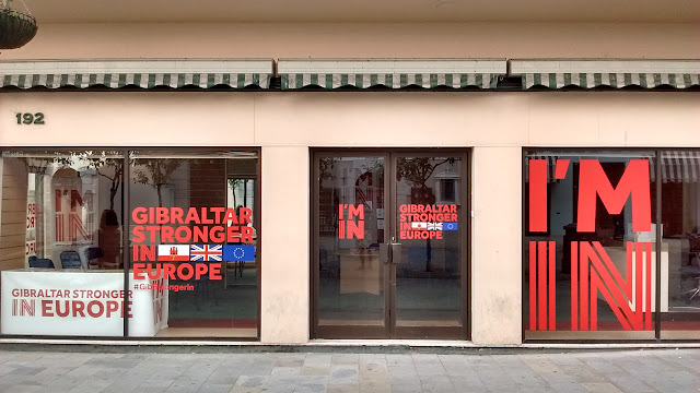
Photo of the Gibraltar Stronger in Europe campaign office on the British territory's main street. Gibraltar's population is overwhelmingly against a so-called Brexit, or departure of the UK from the European Union.
Subscribers click here to view this article in the ad-free members area. Not a member yet? Learn about PolGeoNow subscriptions!

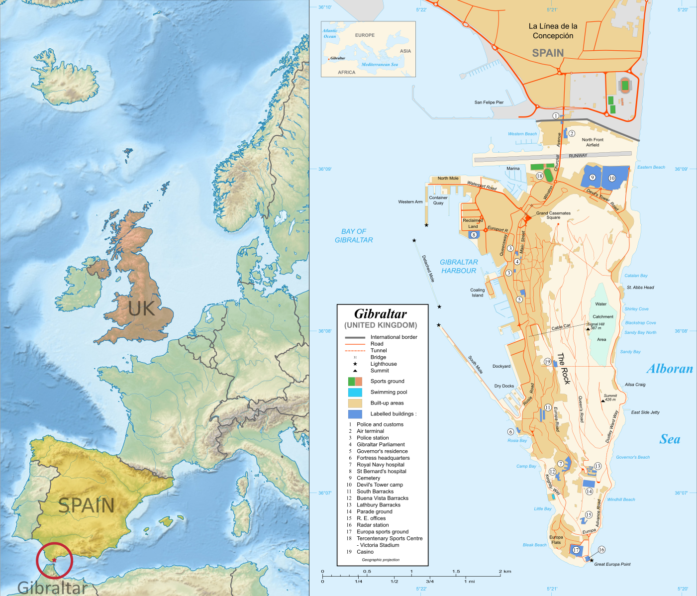
Map of Gibraltar and its location in Europe relative to the UK and Spain
Right: Map of Gibraltar by Eric Gaba (source; CC BY-SA)
Left: Gibraltar's location in Europe (based on this Wikimedia Commons map by TUBS; CC BY-SA)
Gibraltar prepares to vote on whether UK should leave European Union
Last month, PolGeoNow's Evan Centanni and Meihsing Kuo visited the small British territory of Gibraltar (pronounced "jih-BRALL-ter"), one month ahead of the UK's referendum on whether to leave or remain in the European Union (EU).

Gibraltar, a tiny peninsula connected to Spain - and claimed by the Spanish government - is the only British overseas territory that's part of the EU. It's also the only external territory whose residents are eligible to vote in the so-called "Brexit" referendum without living in the UK proper. ("Brexit" is an abbreviation for "British exit" from the EU.)

Friday, September 19, 2014

Maps of How Scotland's Regions Really Voted

Good geographers know that maps can lie to you. Every map emphasizes some aspects of a place at the expense of others, giving it a lot of power to lead careless readers astray. Maps of Scotland's recent independence referendum are misleading us about the reality, even if not intentionally.

Premium members click here to view this article in the ad-free members area. Not a member yet? Subscribe now!
 
Map of results in Scotland's September 18, 2014 independence referendum. Voters were polled on whether or not to separate from the UK. Map shows relative proportion of yes and no votes for each of Scotland's council areas, using a gradient rather than contrasting colors for small differences.
Map by Evan Centanni, based on blank map by TUBS and NordNordWest (CC BY-SA)
By Evan Centanni

Misleading Maps
By now you've probably heard the results of Scotland's independence referendum: voters chose "no" by a solid margin of 55% to 45%. Check out our previous article to learn more about what would have happened if Scotland had voted "yes".

Maps like this one from the BBC and this one from Wikipedia have popped up since the results came out, showing how each of Scotland's council areas voted. Most of the country is in red for "no", with a few "yes" areas in green.

But if one area went 51% for "yes", and another 51% for "no", those two areas actually voted almost identically - yet contrasting red/green maps make us feel like they're polar opposites (not to mention that one-in-thirty readers has trouble seeing the difference between red and green).

How the Councils Really Voted
Whether each area's people voted just over or just under 50% in favor isn't actually that important. What matters is how far the balance was tipped in each region. This is not the U.S. presidential election, where the final vote is actually made by delegates obligated to go by the majority in each state. All the votes across Scotland were pooled together to determine the result, so which side of the 50-yard line each area came out on has no effect .

Tuesday, September 16, 2014

Scottish Independence Poll: What is Scotland, and What Will Happen if it Votes to Leave the UK?

Premium members click here to view this article in the ad-free members area. Not a member yet? Subscribe now!
 
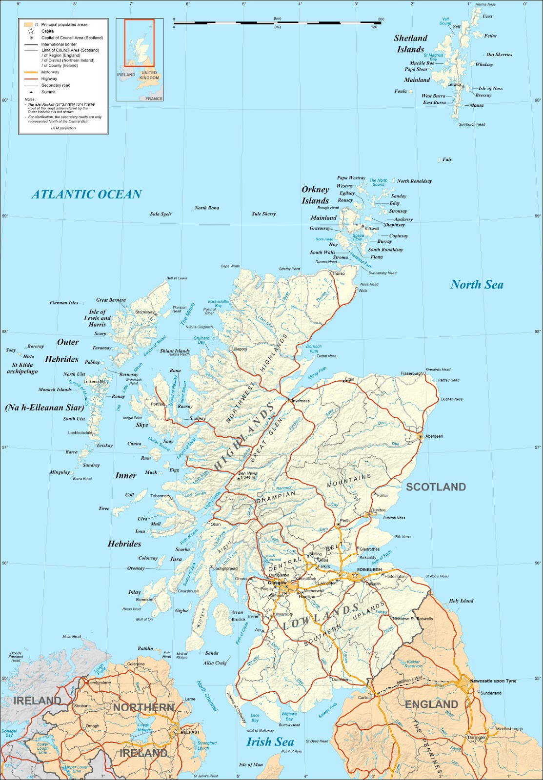
Map of Scotland. On September 18, 2014, Scotland will vote on whether to leave the UK and become an independent country.
Map of Scotland by Eric Gaba (source). License: CC BY-SA
By Evan Centanni

Scotland's Independence Vote

On Thursday (September 18), residents of Scotland will vote in a referendum on whether to leave the United Kingdom (UK). But is Scotland a country already? What will happen if voters choose "yes" in the referendum? And what other changes would this bring to Scotland and the UK's political geography? Read on for the answers to these questions and more!

Crash Course: History of Scotland

Scotland is the name of the northern third of Great Britain, the main island of the UK, which is shared with England to the south and Wales to the southwest. It originated as the Kingdom of Alba, an independent Celtic country that was unified around the year 900.

It remained an independent kingdom throughout the Middle Ages, gradually absorbing Anglo-Saxon culture from the south until it came to be ruled by English-speaking monarchs, who called it "Scots" or "Scotland" after the Latin name for the Gaels, the predominant Celtic people of the region.

Tuesday, March 12, 2013

Map: The Falkland Islands' Disputed Seas

The Falkland Islands, a South Atlantic territory disputed between the U.K. and Argentina, held a status referendum this week in which 99.8% of voters defied Argentina by choosing to remain British. But it's not just about the islands - also at stake are legal rights to the sea for hundreds of miles around.
Map of maritime jurisdiction in the seas surrounding the Falkland Islands (Islas Malvinas), including territorial sea, internal waters, and exclusive economic zone (EEZ)
Zones of maritime jurisdiction around the Falkland Islands, highlighting area disputed between the U.K and Argentina. Map by Evan Centanni (country coastlines from the Natural Earth dataset). All rights reserved.
The Disputed Seas of the Falkland Islands
The Falkland Islands are administered by the U.K. as an overseas territory, but are also claimed based on historical arguments by Argentina, which calls them "las Islas Malvinas". Both countries have signed and ratified the United Nations Convention on the Law of the Sea (UNCLOS), which defines ownership and legal rights for the waters surrounding coastal countries. According to the UNCLOS, each country is entitled to three basic zones of control in its surrounding seas: